Wednesday, December 23, 2009

Nightmare Storm for Christmas brings visions of Halloween '91?

8-14" in the Cities, 16-24" in STC, Willmar, Brainerd likely – Winter Storm Warning begins at 9 PM tonight – And what about Santa?


NWS Chanhassen Weather Story

Watch live streaming video from weathrlver at livestream.com

As we await our snowstorm to develop, there are new details that put some of the heaviest snow totals in areas from Worthington to Windom to Willmar to STC to Brainerd and up towards Duluth. It looks likely that this area, along with areas west of here, will remain within the snow bands and have no turn over to some sleet and ice; therefore we could see the potential of up to 2 feet of snow by the time all is said and done on Saturday. If I had to narrow it down for STC, I would say about 18-22" at this time. Meanwhile, in the metro area, the totals will vary from 8" in the southeast (Cottage Grove area) to 14" in the northwest (Maple Grove area).

But why so much snow? Snow will just about be continuous across the area for three days – considerably longer than the 12 hours or so typical of a normal Minnesota snowstorm. Plus, a chunk of the snow will fall as the storm begins to develop over Iowa as the storm takes its slow time to move. Snowstorms that last a longer period of time often are the ones that top the record snowfall records – and that is true in the comparison that National Weather Service offices are making:

From NWS Twin Cities: THIS STORM SYSTEM IS REMINISCENT OF THE INFAMOUS HALLOWEEN BLIZZARD OF 1991...OVER 27 INCHES OF SNOW (28 inches fell in the Twin Cities and 37 inches in Duluth)

From NWS Sioux Falls, SD: REMINISCENT OF A STORM WHICH PRODUCED 30+ INCHES AT WILLMAR, MN SEVERAL YEARS BACK.

Winter Storm Warnings are out across most of the upper Midwest, including the entire state of Minnesota -- but a Blizzard Warning has recently been issued for the Duluth area.
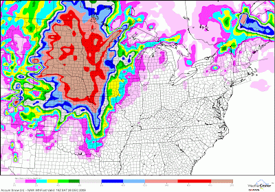

One computer model estimated snowfall

Snow Timeline

The first wave of snow should begin later tonight, probably about midnight or so, and will be heavy from that period onward through tomorrow afternoon. A low pressure center is in the Iowa area and will likely stall out for the next couple days before losing steam. During the day tomorrow, sleet and freezing rain will mix in from the Twin Cities south and east, but should remain all wet, heavy snow elsewhere in the state. There will be a lot of trouble getting out of the area as early as tomorrow morning, as 2-4" are likely overnight in the St. Cloud area, with totals between 8-12" (if not more) by tomorrow evening.

A quick lull could occur from about mid afternoon Thursday until about midnight Thursday Night, but another surge of precipitation (second wave) should reach the central Minnesota area Friday morning due to a new low that forms in Texas later tonight and moves into Iowa on Friday. Another 4-8"+ is possible from Thursday Night through Friday afternoon and evening. It's these types of snows that should allow many areas such as Worthington, Windom, Willmar, STC, Brainerd, and Duluth see 16-24" of snow by the storm is mainly over Friday evening. The low will then drift off into Wisconsin and Canada over the weekend, and we could see another couple inches Friday Night into Saturday, but it will not be like the steady, heavy snow we see happening over the next couple days.

A few things could still affect this forecast. First, any westward jog of this system could affect the areas of heaviest snow and that get into the icy mix. Second, if the warm air mixes in farther north and west, creating a bigger icy mix and knocking accumulations down. And third, thundersnow. I mentioned this possibility yesterday, where aloft thunderstorms could concentrate heavier snowfall in areas. This is looking possible given the moisture and power this storm is likely going to have. This would reduce heavier snowfall elsewhere.

There is one big change in this forecast: Development is slower than was originally expected. Therefore it needs to be stressed to TRAVEL NOW! Travel should remain somewhat okay in most of MN, WI, ND, and SD today, but you may encounter some patchy ice in IA and southern MN, especially as we go later into the afternoon. Now is definitely the time to travel before the snow begins here (or the main icy component in Iowa). More than likely enough ice is possible to down power lines from Omaha through much of Iowa, so be prepared to be without power if you are heading to Grandma's in that direction. But, again, it must be stressed that if you do not want many travel problems, TRAVEL TODAY! LEAVE NOW! JUST STOP READING AND GO! (OK, don't stop reading. Please?) Also, get your shopping done today, as this storm will already be causing troubles for short distance traveling by tomorrow morning.

Heavy snow will of course have impact on travel, but areas such as Iowa and southeast Minnesota could accumulate up to an inch of freezing rain or sleet, enough to down tree branches and power lines. As you head toward the metro, there will be less accumulating ice, but snow will fall on top of the ice creating very slick conditions. Plane, train, and automobile traffic will be affected.

You can check up on the latest road conditions through the following links:

You will also need a car emergency kit, regardless of where you're going. While it won't be that cold, and the roads could be passable but snow-covered, you can never expect what may happen. Please see the Winter Storms: The Deceptive Killers document from the NWS. Meanwhile, if you're in the area where significant freezing rain or sleet is expected, be prepared to lose power, so check the same document for home supplies suggested for power outages.

Check up on the current location of the precipitation through radar:

Check on air travel conditions from the FAA web site.

Actual ground reports:

And, local weather service offices with more on the current watches, warnings, and snowfall reports, along with record snowfall information:

Be prepared for this storm – that must be said a few times. This is not a paralyzing storm for most in the area – we have been through worse, and are hardy Minnesotans. We will get through this. The main concerns are the icy mix, along with the fact that the storm is coming at a busy travel time for many. I have it on good authority, though, that Santa will be able to make it to all the houses on Christmas Eve Night.

So there's your afternoon update. Future updates from me probably won't be as detailed (more like updating snow totals and rehash of this post) but stay tuned to these four sites for updates:

Get ready for the snow – and remember: Enjoy the season! Plus, five-fingered waves, please! And of course, any questions that you have please post and I will do my best to answer!

Tuesday, December 22, 2009

"Snowpocalypse" to dump 12"+ over the area

WINTER STORM WARNING IN EFFECT MIDNIGHT WEDNESDAY NIGHT THROUGH 6 AM SATURDAY... 12-16" STC, 10-14" MSP...


Watch live streaming video from weathrlver at livestream.com


The storm is getting closer, and it is looking more and more likely that places out towards the St. Cloud area could see a foot or more of snow by the time all is said and done on Saturday.

It must be stressed that the picture basically remains the same from yesterday. Snow, ice, poor travel and windy conditions will affect most of the Upper Midwest starting Wednesday and lasting through Saturday. And, of course, the storm is coming from the south and west, so the storm will start sooner in places such as Iowa and Nebraska and make travel tricky as soon as even later tonight.

The later model runs have a more westward motion, bringing the lows track, of course, west. The models have the initial low dying out sometime during the day on Christmas Eve over western Iowa and reforming south and east before tracking through central Iowa on Christmas and into Saturday before making its way through Wisconsin throughout the day Saturday into Sunday.

It appears snowfall will spread north from Iowa Wednesday morning, and the first waves of snow may be approaching the area late Wednesday afternoon into early evening.

There are many question marks remaining with this storm, not only revolving around the track but the initial surge of warm air Wednesday into Thursday. This surge could make it into the Twin Cities metro area and create a period of sleet or even freezing rain, mainly during the day Thursday, before it changes back to all snow. More ice is expected as you head south and east from the Cities, making travel even more difficult. The only silver lining?: Less snow for the Cities.

It is likely to stay all snow, though, here in the St. Cloud area unless we get the low to track even more west than it is already. Either way, I do expect a heavy snowfall from the west Metro and westward. The heaviest of the snowfall will come Christmas Eve and Christmas Day before the system starts to push out on Saturday.

Snow, but on the lighter side, will linger throughout the rest of the weekend, but travel will likely remain difficult due to snow totals, any ice accumulations that occur, and some blowing and drifting that will occur from Wednesday Night onward.

Now, the snow totals. We look for consistency between models, and that is surprisingly what we are getting! (It's honestly a miracle that the computer models are staying so consistent with each other on the path and totals!) Even then, though, there remains a few questions about total amounts, not only in the Twin Cities but here in St. Cloud too.

The problem isn't moisture, though. We will have very humid Gulf air being pumped into the storm -- its what all that moisture could cause. We could have strong thunderstorms develop south of us. That moisture will get pushed into the cold sector eventually, but it could shut off moisture early in the storm -- it's very possible, but we should still get some early snow. Another thing I'm concerned about is thundersnow that could ring the atmosphere out of moisutre (and create higher snow totals in places!)

For now, though, I'm going to say 10-14" for the Twin Cities area (a lot of it will depend on the duration of any ice).

For the St. Cloud area, I am squarely putting us in the 12-18" range. Yes, I am putting St. Cloud on the edge of some of the heaviest snow possible from the storm. But we will not be in the heaviest. I'm thinking up to 20" could fall in places like Willmar southward towards Worthington and the Sioux Falls area. Here's one of the models showing this type of possibility. Expect 1-2' amounts over a good chunk of southern and western Minnesota.

If you want me to break this down for the St. Cloud area -- lets say 1-3" possible Wednesday Night, 3-6" Thursday, another 3-6" Thursday Night, 2-4" Christmas through Christmas Night, lingering snow (maybe an inch) through the rest of the weekend.

Winds are another factor, as by Thursday winds will pick up from the northerly directions at 20-30 mph, causing blowing and drifting and making travel even worse.

Some kind travel advise: Do not expect to get anywhere fast after the storm starts Wednesday Night until the storm ends Saturday or Sunday. If you must travel -- GO SLOW! Roads will deteriorate fast on Thursday and stay that way through Saturday. I know, its Christmas, you want to travel to relatives or whatnot. It might be best to stay home if you can -- but again, take it slow if you must.

Some things are still uncertain, but it is looking more and more likely the area will get dumped on by this storm. Make sure you stay ahead of the storm and don't get caught in it -- if you must travel make sure you have your car ready if you get stuck somewhere. Otherwise, get ready to shovel your butts off!

Depending on if I see anything important tonight, the next update for this forecast will likely be Wednesday before the storm starts hitting.

Monday, December 21, 2009

The Upcoming Christmas Snowpocalypse?

Winter Storm Watch in effect from Wednesday Evening through Friday


First, this is not meant to scare you or anything, just to let you know about the possibilities of an large upcoming storm that could wreck havoc over the Christmas period for travel.

Within the past day or so, the computer models have started coming together and placing a possible snowstorm over southern Minnesota and the St. Cloud area from Wednesday Evening through Christmas. The models have the low of the storm passing somewhere between Chicago and southeast Minnesota, and bring a sizable amount of snow to the area. Right now the models are outputting as much as 20" over the Twin Cities (12z GFS Cobb, picture). The best estimate, though, is a good 6-12" of snow with even more possible.

A few factors are in favor for a large snow total. First, a favorable track has some of the heaviest snow over the area. Already, they are warning in the Sioux City area of 10-20" of snow from the storm. It would be that type of snow that lifts northward into our area. Also, the Gulf of Mexico will be open for moisture, allowing a wet snow to accumulate with a) snow-to-liquid ratios between 10-15:1, and b) liquid amounts possibly over 1".

I still have some worries about the storm though. First, the track is still very uncertain. We are still a number of days away from the storm, and the track could change by then. Also, the first surge of snow on Wednesday Night will have a warm factor to it, which could mean there is a mixture of sleet. It looks like, though, that that portion may only make it to the Rochester area, so that we will still see an entire snow event.

Right now, the system will come in three parts. First will be Wednesday into Wednesday Night. Next part will be later Thursday through Christmas Morning, and the third while the storm is departing late Friday into Saturday Morning. Also, especially from Thursday onward, winds will pick up from the north at 20-30 mph, creating some blowing and drifting.

Again, the best estimate could only be up to a foot of snow, but it will be redefined as we get closer to the storm date. Stay tuned as this storm will likely wreck havoc on many travel plans starting Wednesday.

URGENT - WINTER WEATHER MESSAGE
NATIONAL WEATHER SERVICE TWIN CITIES/CHANHASSEN MN
351 PM CST MON DEC 21 2009

...FAST MOVING STORM SYSTEM BRINGING LIGHT SNOW TO SOUTHERN
MINNESOTA OVERNIGHT...

...WINTER STORM WATCH FOR CENTRAL AND SOUTHERN MINNESOTA...AND
PORTIONS OF WEST CENTRAL WISCONSIN STARTING WEDNESDAY AFTERNOON...

.A FAST MOVING...BUT POTENT WINTER WEATHER SYSTEM WILL BRING A
PERIOD OF LIGHT TO MODERATE SNOWFALL OVERNIGHT ACROSS PORTIONS OF
SOUTHERN MINNESOTA...WITH THE HEAVIEST ACCUMULATIONS ALONG THE
IOWA BORDER.

A MORE SIGNIFICANT STORM SYSTEM IS EXPECTED TO IMPACT THE UPPER
MIDWEST STARTING WEDNESDAY AFTERNOON...AND LASTING THROUGH FRIDAY.
DUE TO THE STRENGTH OF THIS SYSTEM AND THE PROLONGED PERIOD FOR
WHICH THE SNOWFALL IS EXPECTED...THERE WILL BE MAJOR IMPACTS TO
TRAVELERS...ESPECIALLY DUE TO THE UPCOMING HOLIDAY.

ALTHOUGH THERE REMAINS SOME MINOR TIMING ISSUES AND THE EXACT
STORM TRACK IS STILL UNCLEAR...THE LARGE NATURE OF THIS
SYSTEM...AND EXPECTED HIGH ENERGY AND MOISTURE CONTENT...WILL
LEAD TO A BROAD AREA OF HEAVY SNOW...SLEET AND FREEZING RAIN
ACROSS THE UPPER MIDWEST. THIS STORM SYSTEM IS SO COMPLEX THAT
WILL BE THREE BOUTS OF PRECIPITATION WITH THIS EVENT. THE FIRST IS
EXPECTED TO DEVELOP WEDNESDAY AFTERNOON AND SPREAD NORTHWARD
ACROSS THE UPPER MIDWEST. THIS WAVE HAS ABUNDANT WARM AIR
ASSOCIATED WITH IT...SO THERE WILL BE A MIXTURE OF SLEET AND
FREEZING RAIN AS FAR NORTH AS THE IOWA BORDER. THE NEXT WAVE IS
EXPECTED TO IMPACT THE AREA THURSDAY AFTERNOON THROUGH EARLY
FRIDAY MORNING WITH WIND SPEEDS INCREASING FROM THE NORTH. THE
LAST WAVE WILL LIKELY BE THE WRAP AROUND MOISTURE WHICH WILL OCCUR
FRIDAY AFTERNOON AS THE STORM SYSTEM BEGINS TO DEPART THE REGION.

AS THE STORM SYSTEM APPROACHES...SNOWFALL AMOUNTS WILL BE FURTHER
REFINED...BUT TOTAL ACCUMULATIONS COULD EXCEED A FOOT OVER PARTS
MINNESOTA AND WISCONSIN. GIVEN THE TIMING OF THIS SYSTEM...HOLIDAY
ROAD AND AIR TRAVEL WILL BE SIGNIFICANTLY IMPACTED.

MNZ041>045-047>063-065>070-076>078-WIZ014>016-023>028-220600-
/O.NEW.KMPX.WS.A.0008.091224T0000Z-091226T0000Z/
DOUGLAS-TODD-MORRISON-MILLE LACS-KANABEC-STEVENS-POPE-STEARNS-
BENTON-SHERBURNE-ISANTI-CHISAGO-LAC QUI PARLE-SWIFT-CHIPPEWA-
KANDIYOHI-MEEKER-WRIGHT-HENNEPIN-ANOKA-RAMSEY-WASHINGTON-RENVILLE-
MCLEOD-SIBLEY-CARVER-SCOTT-DAKOTA-LE SUEUR-RICE-GOODHUE-POLK-
BARRON-RUSK-ST. CROIX-PIERCE-DUNN-PEPIN-EAU CLAIRE-
INCLUDING THE CITIES OF...ALEXANDRIA...LONG PRAIRIE...
LITTLE FALLS...PRINCETON...MORA...MORRIS...GLENWOOD...ST. CLOUD...
FOLEY...ELK RIVER...CAMBRIDGE...CENTER CITY...MADISON...BENSON...
MONTEVIDEO...WILLMAR...LITCHFIELD...MONTICELLO...MINNEAPOLIS...
BLAINE...ST. PAUL...STILLWATER...OLIVIA...HUTCHINSON...GAYLORD...
CHASKA...SHAKOPEE...BURNSVILLE...LE SUEUR...FARIBAULT...
RED WING...AMERY...BALSAM LAKE...RICE LAKE...BARRON...LADYSMITH...
HUDSON...NEW RICHMOND...RIVER FALLS...PRESCOTT...MENOMONIE...
BOYCEVILLE...DURAND...PEPIN...CHIPPEWA FALLS...BLOOMER...
EAU CLAIRE...ALTOONA
351 PM CST MON DEC 21 2009

...WINTER STORM WATCH IN EFFECT FROM WEDNESDAY EVENING THROUGH
FRIDAY AFTERNOON...

THE NATIONAL WEATHER SERVICE IN TWIN CITIES/CHANHASSEN HAS ISSUED
A WINTER STORM WATCH...WHICH IS IN EFFECT FROM WEDNESDAY EVENING
THROUGH FRIDAY AFTERNOON.

* TIMING...SEVERAL PERIODS OF SNOW ARE EXPECTED FROM WEDNESDAY
EVENING THROUGH FRIDAY AFTERNOON.

* ACCUMULATIONS...SIGNIFICANT AMOUNTS OF SNOW WILL OCCUR OVER THE
WATCH AREA...WITH PERIODS OF HEAVY SNOW POSSIBLE AS THE STORM
INTENSIFIES THURSDAY AND FRIDAY.

* SURFACE VISIBILITY WILL BE SIGNIFICANTLY REDUCED AS WIND
INCREASE TO 20 TO 30 MPH FROM THE EAST ON WEDNESDAY...BECOMING
MORE NORTHEAST...THEN NORTH ON FRIDAY.

PRECAUTIONARY/PREPAREDNESS ACTIONS...

A WINTER STORM WATCH MEANS THERE IS A POTENTIAL FOR SIGNIFICANT
SNOW...SLEET...OR ICE ACCUMULATIONS THAT MAY IMPACT TRAVEL.
CONTINUE TO MONITOR THE LATEST FORECASTS.

&&

$$

JLT/JPR

Wednesday, September 2, 2009

Eleven Tornadoes Touched Down August 19

This is from the NWS. For more information, visit http://www.crh.noaa.gov/news/display_cmsstory.php?wfo=mpx&storyid=30471&source=0

Minneapolis, MN EF-0 Tornado

A damage assessment team from the National Weather Service in Chanhassen surveyed storm damage in Minneapolis. They confirmed that a tornado touched down in south Minneapolis, initially near East 53rd Street and Park Avenue around 150 PM CDT. The tornado then moved north from that location toward downtown, and eventually lifted near the Convention Center around 200 PM CDT. Damage was most intense and concentrated from East 45th Street north to East 38th Street, generally along Park, Oakland, Portland, and 5th Avenues. The track shifted slightly west of due north with time. The most intense damage was consistent with EF-0 intensity, with wind speeds between 75 and 85 MPH. Numerous trees were downed in the area, with damage to a number of homes and structures as well. Much of the structural damage was due to falling trees. The tornado track was approximately 4.5 miles in length, although it may have lifted for a brief time between East 29th Street and the Convention Center area. Maximum track width was approximately 500 yards, although the most intense damage occurred along a path approximately 250 yards wide.

Minneapolis Tornado Track Map
Minneapolis Tornado Path Map

Cottage Grove, MN EF-1 Tornado

A National Weather Service assessment team also surveyed storm damage from the southern end of Cottage Grove, Minnesota. They confirmed that a tornado touched down near 122nd Street just west of Highway 61 in southern Washington County around 240 PM CDT on the afternoon of August 19th, where it initially produced EF-0 damage to a roof, playground equipment, and a garage door. The tornado then tracked northwest across Lofton and Lockridge Avenues just west of Highway 61 in Cottage Grove, where it produced low end EF-1 damage. The tornado either uprooted or sheared off a swath of large trees, many that were 2 to 3 feet in diameter. The approximate path length of this tornado was 1200 yards, and the maximum width was 75 yards. Estimated maximum winds with this tornado were 90 to 100 MPH.

Washington County Tornado Path Map

Hudson, WI Area EF-0 Tornado

Damage from another tornado was found by the National Weather Service damage assessment team near County Road UU and Larson Lane near Hudson, Wisconsin. This tornado produced EF-0 damage, and touched down shortly after 3 PM CDT. The tornado moved north-northeast and either downed or uprooted several 1 to 2 foot diameter trees, and also caused minor roof damage to multiple houses. The approximate path width was 25 yards, and the length was about 600 yards. Estimated maximum winds with this tornado were 80 to 85 MPH.

Hudson, WI Tornado Track Map
Hudson, WI Tornado Path Map

Marine on St Croix, MN EF-0 Tornado

A damage survey determined that this tornado touched down in the southwest corner of Marine on St Croix at 325 pm and moved toward the northwest, knocking down a couple dozen trees and large limbs. It dissipated just northwest of town after being on the ground for 0.7 mile. Winds were estimated at 65 to 70 mph. Its maximum width was 40 yards.

New Trier, MN EF-1 Tornado

A damage survey was also performed on the area four miles north of Cannon Falls, MN, or just southeast of New Trier. A tornado touched down and almost immediately hit a farmstead. A roof was completely removed from a farm house, windows were blown out, and several sheds and other outbuildings were severely damaged. The tornado was initially about 50 yards wide, then narrowed to about 20 yards as it traveled through some corn fields and struck two other residences. Like several other tornadoes this day, it moved toward the north-northwest, ending one mile southeast of New Trier. Maximum wind speeds were likely around 90 or 95 mph, and path length was 1.6 miles. Touchdown was at approximately 216 pm.

North Branch, MN EF-0 Tornado

The assessment team also confirmed that a tornado touched down in North Branch, just southeast of the middle school. It tracked north-northwest through fields into a neighborhood near 2nd and 3rd Avenues and Cedar Street, then lifted near Rivercrest and Riverview Courts. The track was approximately 1 mile in length with a maximum width of approximately 200 yards. Damage was consistent with EF-0 intensity, with winds between 70 and 80 MPH. Touchdown was at approximately 400 pm.

Ham Lake, MN EF-0 Tornado

A storm chaser witnessed and photographed a brief tornado in a sparsely populated section of Ham Lake at 307 pm. No damage was reported.

Rural Ellsworth, WI EF-0 Tornado

A damage survey revealed a brief tornado touched down 5 miles southeast of Ellsworth and tore through a couple fields of corn. The width was rather narrow, only 20 yards at most. It was on the ground for only 0.2 mile, just north of the intersection of County Road V and DD. Touchdown time was about 257 pm, and wind speeds were about 65 to 70 mph.

Emerald, WI EF-0 Tornado

A storm spotter followed and photographed a tornado that briefly touched down several times as it moved northward, tracking from 3 miles southwest of Emerald to 1.4 miles west of Emerald. Tree limbs and other vegatation were occasionally tossed in the air. This occurred from 358 pm to 402 pm. Path length was 1.4 miles and the maximum width was 25 yards. Wind speeds were about 65 to 70 mph.

Forest, WI EF-0 Tornado

A storm spotter followed and photographed a tornado that briefly touched down several times as it moved northeast, from just west of Forest to 1 mile north of Forest. Tree limbs and other vegetation were occasionally tossed in the air. Time of this tornado was from 411 pm to 415 pm. Path length was 1.7 miles and maximum width was 25 yards. Wind speeds were about 65 to 70 mph.

Springfield, MN EF-0 Tornado

Skywarn spotters witnessed and photographed a tornado briefly touching down in Brown County, three miles east of Springfield, at 628 pm. Only minor crop damage was found in open areas. Wind speeds were approximately 65 to 70 mph.

Thursday, August 27, 2009

Good Fair Weather Today... Not so much in next few days... And more on TS Danny

Ah, its the start of the Great-Minnesota Get Together. The sign that summer is coming to an end for a lot of people (for some, its already ended) and typically hot and humid. Well, in 2009 the first part is still true, but at least for this first weekend that second part will be far from the truth. Because the State Fair is this weekend, we nominate this for the Weekend Getaway, a new feature for the blog where we will try to highlight an event that occurring or a certain place that you, the reader, are wondering about and give you the weekend forecast for the area. It may not happen every weekend, then again it might not happen after this weekend. A lot of this though comes upon you: We will take suggestions of events or locations you want the Weekend Getaway to be. To do this, leave me a comment at either my Facebook page or at the official blog at http://weathrlver.blogspot.com . Bring your suggestions, and if its an event, make sure you include the dates of it -- the best way to do events though is to submit them early in the week of the occurrence. That way it'll still be fresh in my mind before the weekend comes. And this weekends is easy -- it may be a degree or two warmer in St. Paul this weekend, but it will be just about the same weather we get here in St. Cloud.

We'll start off with the good news: One more day of summer-like weather today! Sunshine should regin for most of the day and we will approach a high of 80.

Tonight the cold front will start to push into the area, bringing with it mostly cloudy skies and a 20% chance of some showers and storms my morning, not likely to drop much if any rainfall overnight. Low 56.

Friday some showers and storms will continue over the area as the cold front moves though... should be scattered and we won't get much rain. Rain should clear out by afternoon, but it will remain cloudy with a high of 70.

Friday Night we'll see skies start to clear out as another cold front moves through, but some mighty fine cold air will be moving over the area with a low of 47. Wind chills possible.

Saturday has the chance of an isolated shower, otherwise we'll see a mix of clouds and sun with the coldest air so far this "warm" season with a temperature more typical of late September with a high of 65. (Record cold high: 59 in 1965)

Saturday Night the core of the cold air will move over us, and with clear skies and calming winds we will see lows reaching an incredible 42 for this time of year. (Record cold low: 38 in 1974)

Sunday should be a little warmer with sunnier skies, but highs will only top out around 69.

Looking ahead we should see highs start moderating back upward, and could see highs in the lower 80s for the last weekend of the State Fair.

The Tropics

Tropical Storm Danny is attempting to get a little bit more organized in the area of the Bahamas, but there is still much uncertain about this storm. Latest forecasts have this storm just skirting the Outer Banks and the Cape Cod area, but with Danny moving more westward in the latest forecast the model tracks could move more leftward in the next few hours, posing more of a threat to the coast. Either way, Danny is expected to become a hurricane sometime tomorrow night, but only remain a minimal hurricane with winds 75-80 mph. Whether this storm just misses the coast, or actually makes a landfall in New England, the east coast is expected to see some heavy rainfall and increasing wave height over the weekend, along with some gusty winds.

Meanwhile, we are watching a wave out by Africa that has about a 30% chance of becoming a system within the next 48 hours. Current models picking up on this wave have this becoming out next TS, and even Hurricane, within the next 5-7 days by the name of Erika.

Wednesday, August 26, 2009

Watching for a MUCH cooler weekend -- Keep the pitchforks away! -- And TS Danny

I can say that summer will continue through tomorrow. After that... be prepared for some fall-like weather moving in for the weekend (right in time for the Great Minnesota Get-Together)!

*Audience starts getting out their pitchforks and torches*

Wait, wait! Let me do the good news first! Today will see a mix of clouds and sun and we should be able to get up to around 77 for a high.

Tonight we'll see clear skies and 48.

More sun will reign Thursday with a high of 80.

The regime change starts Thursday Night with a cool front moving through, bringing a chance of showers and thunderstorms and lows getting to 57.

Friday rain should continue for at least the first half of the day, otherwise a mix of clouds and sun with a high of 71.

Saturday we will continue to see a mix of clouds and sun, but the ability of some showers and thunderstorms will be alive in the afternoon and evening due to an extreme difference between temps in the upper atmosphere and at ground level. Sunday should be a bit more sunny though. The big problem should be the temperatures, which is why you would want to use a pitchfork to me. I'm guessing that on both Saturday and Sunday highs will BARELY make it to the middle 60s, if even that!!! And to top that off... lows Saturday and Sunday Nights may plummet all the way down to the lower 40s and lower 30s (with a likely wind chill too)!!! And up north, especially Sunday Night, northern MN may drop low enough where frost/freeze advisories may need to be issued!

We should begin a slow warm up though at the beginning of next week. At least that's what I'm hoping. The cool summer continues... and the long fall season looks likely to begin. Oh, and to top it off, it looks like we could have a warmer than normal winter. Yeah.

Meanwhile in the Tropics, we had the formation of Tropical Storm Danny earlier today. Current forecasts have this storm forming into a Cat 1 Hurricane in the next few days and really affecting the coastline on the eastern seaboard by this weekend -- they have the storm skirting the Outer Banks of NC late Friday/early Saturday and possibly making a landfall in the Long Island/Cape Cod areas late on Saturday. Forecasts for tropical systems though are typically not that accurate, especially early on in a systems formation and even 3-5 days from now they are the most accurate. But Tropical Storm Danny is definitely a storm to watch for the east coast and right now poses more of a threat than Hurricane Bill did.

Tuesday, August 25, 2009

Sunny for now... Even cooler weekend?

Don't have to say much over the next few days...

Tonight mainly clear with some patchy fog. Low 52.

Wednesday mainly sunny. High 77.

Wednesday Night continued clear. Low 51.

Thursday (the opening of the Minnesota State Fair) continued sunny. High 79.

Friday then starts a pattern of even cooler weather that'll last throughout the weekend, with highs barely making it to around 70 on Friday with some rain/storms, and then likely not making it out of the 60s during the weekend (barely making it out of the 50s on Saturday). Not great weather for the State Fair... lets hope it gets better!

Monday, August 24, 2009

Rain Possible Later Tonight

Currently in STC we have sunny skies, but as the day rolls on we will start to see the sky cloud up ahead of a cold front moving into the area. High of 83. It will also be breezy with winds out of the south between 25-30 mph.

After sunset tonight rolls in the chance of some showers and thunderstorms, a chance that we will put at about 50-60% at this time. Otherwise it will be mainly cloudy with a low around 63. Rainfall around a half an inch.

Tuesday could see some lingering showers and storms in the morning, but will eventually be clearing back out. High of 78.

Tuesday night will see mainly clear skies with some fog likely, in areas likely dense. Low 55.

Wednesday more sunny skies and 78.

Rest of the week should stay dry, but a even greater cool down could be in store for the weekend... stay tuned...

Friday, August 21, 2009

Weekend looks nice, but rain returns by Monday Night

Ah, its the weekend before some kids go back to school around here (I'm talking about us college kids) and back into the workings of homework and studying hard for tests. After a mainly wet week and even some freak tornadoes, we are putting together a very nice weekend full of sunshine... even if it might be on the "cool" side of things. But then again, when haven't we really been on the cool side this summer -- it has just been one of those years.

After some fog tonight, I expect mainly sunny skies to reign the weekend, with highs in the lower 70s Saturday and approaching 80 by Sunday -- nice moving in weather for those moving into the dorms on campus.

For the first day of classes on Monday, that is when we'll actually warm into the lower 80s, though with increasing clouds in the afternoon leading to a chance of some showers and thunderstorms Monday Night into Tuesday.

After that, sun will rule the rest of the week with highs mainly in the 70s.

Tonight: Fog likely, otherwise mainly clear. Low 47.

Saturday: Brilliant sunshine. High 73.

Sunday: Continued brilliant sunshine and a little warmer. High 79.

Monday: Sun will give way to increasing clouds with late day showers/storms possible. High 81.

Thursday, August 20, 2009

Freak EF0 Tornado in Minneapolis... But weather will get better

Well, that was sure an interesting Wednesday as almost out of nowhere a EF0 tornado pops down in south Minneapolis and tracks northward along 35W before dissipating as it reached downtown. There was basically no warning of a tornado happening. Heres what happened: An upper-level disturbance (in other words: a counterclockwise-rotating swirl of unusually cold air 4-8 miles aloft with was associated with a low pressure center) sparked a widespread deluge of rain, almost resembling an MCS (meso-convective system) which typically form at night. Even though it was cool ( it was only in the upper 60s) there was just enough instability, wind shear, and pure spin in the atmosphere thanks to the low pressure center to whip up brief, strong, rotating thunderstorms capable of hail and tornadoes, that were capable of dropping small, mainly weak tornadoes that didn't last long. There was little instability, but just enough spin in the lower atmosphere to allow this to happen. It wasn't expected to be a severe weather day, which is the main reason why this came almost out of no where.


This is an image from the SRV (Storm Relative Velocity) radar from the Chanhassen Weather Office. In this image, it shows air moving toward the radar site in green, and air moving away from the radar in red. As you can see, we do have a small ball of red in the sea of green, indicating strong rotation. The images at the beginning are as the tornado touched down around 2 pm, and as we move along a Tornado Warning is finally issued (box in red) soon after the ball dissipates as it reaches downtown, which is likely when the tornado dissipated itself. It appears that the circulation possibly passed over WCCO TV... brings up eerie thoughts if the tornado was still on the ground at that time what it would have done to the downtown area.

Check out this video posted up to Youtube from a security camera located at East Lake and 4th Street. You can literally see the pond at the center of the screen temporarily drain and a tree in the upper right land on a van. You even see the EF0 tornado pass right in front.

But this was definitely an moment where you would go "SHIT!" as the tornado formed without warning 1 mile from the MSP International Airport and 1-2 miles from downtown Minneapolis. Sure it was a weak tornado, but a tornado no matter what is a big deal, especially when it is in a popluated area, especially a downtown area. There is always the rumor that a tornado can't hit a metro area. This tornado definitely eliminates this theory, besides the fact that we had a tornado in Atlanta last year, and in 1999 had tornadoes hit Salt Lake City and Oklahoma City -- besides the fact that a tornado hit south Minneapolis at least 3 other times in history, the last being in 1981.

A study that was issued a few years ago took a fine focus on the Chicago area and what might happen if a major, F3-F5 tornado struck during rush hour. The projections were something you might otherwise see if you watched a horror movie: 3,000 to 5,000 people dead, 20,000-50,000 injured, damage in the BILLIONS of dollars.

Meanwhile, a couple hours later a weak EF1 tornado struck the town of Cottage Grove, an EF0 hit Hudson, WI, and an EF0 hit . Read more on all the tornadoes from the National Weather Service's statement below the forecast.

There is one thing that we need to take out of yesterdays Minneapolis tornado: We are quickly reminded that weather is not an exact science. Nor is our radar systems. Not every small tornado will be picked up by radar as it happens. Not all real threats can be captured by humans or technology as it happens. The human being is responsible for their own safety, not the National Weather Service nor your local meteorologist. My theory is that if there was a tornado elsewhere BEFORE this Minneapolis tornado, the meteorologists would have been on the ball and probably would have caught the circulation on radar of the Minneapolis tornado. Maybe not. But you never know.

But there is something else you can take away from this: Mark it on the calendar, the Storm Prediction Center was wrong again this season. Honestly, they were pretty good last year with predicting stuff, but this year they just seem to be wrong very often. They had a Slight Risk out at 8 AM, but revoked it from the area at 11:30 AM, and only put it back in a 3 PM AFTER the tornado had struck... and then it was almost 5 PM before they ever put out a Tornado Watch!!! Good grief!!!

D.J.'s Weird Theory of the Day: Ok, I came up with this at around 1 AM, so its a little out there. But is this Mother Natures way of getting back at us for such a late start of the severe weather season? Remember, we got to June before we had our first tornadic storm and for the first warning in general to be issued for the 7 county metro area. I know, its out there... but you never know I guess...

Upcoming forecast: Things are starting to clear out right now, but more showers are quite likely later tonight into Friday. The system should finally let its grip go on the area by tomorrow night and skies will clear out and sunshine will be back and with us for the weekend! Some rain might be possible by late Monday, the start of school at SCSU.

Tonight: Mix of clouds and stars early, showers likely moving back in by morning. Low 54.

Friday: Mostly cloudy and rain likely, with the best chance occurring around midday. High 67.

Saturday: Sunny, dry. High 74.

Sunday: Continued sunshine -- almost perfect day to be outside! High 80.

Monday: Increasing clouds, especially in the afternoon. Shower possible late. High 82.

Tornadoes

Minneapolis, MN Area EF-0 Tornado

A damage assessment team from the National Weather Service in Chanhassen surveyed storm damage in the Minneapolis area. They confirmed that a tornado touched down in south Minneapolis, initially near East 53rd Street and Park Avenue around 150 PM CDT. The tornado then moved north from that location toward downtown, and eventually lifted near the Convention Center around 200 PM CDT. Damage was most intense and concentrated from East 45th Street north to East 38th Street, generally along Park, Oakland, Portland, and 5th Avenues. The track shifted slightly west of due north with time. The most intense damage was consistent with EF0 intensity, with wind speeds between 75 and 85 MPH. Numerous trees were downed in the area, with damage to a number of homes and structures as well. Much of the structural damage was due to falling trees. The tornado track was approximately 4.5 miles in length, although it may have lifted for a brief time between East 29th Street and the Convention Center area. Maximum track width was approximately 500 yards, although the most intense damage occurred along a path approximately 250 yards wide.

Cottage Grove, MN Area EF-1 Tornado

A National Weather Service assessment team also surveyed storm damage from the Cottage Grove, Minnesota and Hudson, Wisconsin areas today. They confirmed that a tornado touched down near 122nd Street just west of Highway 61 in southern Washington county around 240 PM CDT on the afternoon of August 19th, where it initially produced EF0 damage to a roof, playground equipment, and a garage door. The tornado then tracked northwest across Lofton and Lockridge Avenues just west of Highway 61 in Cottage Grove, where it produced low end EF1 damage. The tornado either uprooted or sheared off a swath of large trees, many that were 2 to 3 feet in diameter. The approximate path length of this tornado was 1200 yards, and the maximum width was 75 yards. Estimated maximum winds with this tornado were 90 to 100 MPH.

Hudson, WI Area EF-0 Tornado

Damage from another tornado was found near County Road UU and Larson Lane near Hudson, Wisconsin. This tornado produced EF0 damage, and touched down shortly after 3 PM CDT. The tornado moved north-northeast and either downed or uprooted several 1 to 2 foot diameter trees, and also caused minor roof damage to multiple houses. The approximate path width was 25 yards, and the length was about 600 yards. Estimated maximum winds with this tornado were 80 to 85 MPH.

North Branch, MN EF-0 Tornado

The assessment team also confirmed that a tornado touched down in North Branch just southeast of the middle school. It tracked north-northwest through fields into a neighborhood near 2nd and 3rd Avenues and Cedar Street, then lifted near Rivercrest and Riverview Courts. The track was approximately 1 mile in length with a maximum width of approximately 200 yards. Damage was consistent with EF0 intensity, with winds between 70 and 80 MPH.

Southwest and South Central, MN

Skywarn spotters witnessed tornadoes briefly touch down in rural portions of Brown and Blue Earth counties on Wednesday, but only minor crop damage was found in open areas.

Wednesday, August 19, 2009

Deluge of Rain Upon the Area (From Wednesday, Interrupted by Tornados)

Through 1 PM, the St. Cloud Airport has picked up 0.69" since the rain began around 2:30 this morning, and through posting time the D.J. Weather Center has picked up 0.53". More rain will continue throughout the day as more showers and thunderstorms pop up in Iowa and Minnesota then eventually get wrapped around and brought back into the St. Cloud area. Temps are currently in the middle 60s and that is likely where they will stay for the rest of the day. A Flood Advisory is out for Sherburne County as well as part of the Twin Cities -- you can find the statement after the forecast.

More widely scattered showers are possible tonight, Thursday, and even into Friday before things start to clear out. This should lead us to have a nice weekend with some sunshine and highs getting to around 80.

Ragweed season has started, for those of you affected by allergies. Luckily though they should be held down the next few days due to the rain. More than likely though levels will start to increase once again this weekend.
_________

At this point, the forecast was interrupted by sirens and a tornado report in Minneapolis. Stay tuned later today for a rundown of the tornadoes that did occur, and the latest forecast for the weekend!

Tuesday, August 18, 2009

Favre comes on a nice day... not so nice the next few

On a day that has been covered with Brett Farve/Vikings coverage, we can not forget about the wonderful weather that he had to fly up to Eden Prairie in! Farve has just signed a contract with the Minnesota Vikings, a reported 2 year deal worth $25 million. Let's hope this means it is going to be a good season for the Vikings. But now on to weather after this:


Farve gets his #4 jersey via @robolsonfox9

Again, Farve had a brilliant day weatherwise to come up to Minnesota and becoming a Viking. With highs topping out in the mid to upper 70s with mainly sunny skies, a picture perfect summer day, at least in my opinion. Sure, it could be a little warmer for summer, but you got to enjoy the weather, enjoy the season!

Starting as soon as overnight tonight, a chance of showers and storms moves in with a slow moving system, better odds of rain come with it Wednesday afternoon and night. The severe weather chance we had been talking about has shifted more southward into Iowa and Missouri, but there is a chance of an isolated strong/severe storm with large hail and damaging winds as the front moves through.

More showers and storms possible Thursday in the cold air (highs won't make it out of the 60s), and it will be very blustery out.

Some leftovers may be still here on Friday, and we hope we can push everything out and end up with a fairly nice weekend with highs around 80 and mainly sunny skies.

Got an event, or want a specific forecast for somewhere on a certain date (within a few days) leave me a comment and I'll be happy to include it in the forecast!

Tonight: Becoming cloudy with the chance of a shower or storm (20-30% chance). Low 57.

Wednesday: Cloudy. Cool. Showers and storms, especially as we get later in the day (50-60% chance). High 71.

Thursday: Mostly cloudy, continued coolness with continued showers likely (30-40% chance). High 65.

Friday: Clouds should start to clear throughout the day. High 72.

Saturday: Brilliant sunshine returns. High 78.

Sunday: Continued sunshine. High 80.

Monday, August 17, 2009

Cool Weather with Chance of Storms

We're talking storm chances, so we might as well start with the one later today. A "cool" front will pass through the area later today, not doing much temperature-wise over the next few days, but will allow for the chance of some widely scattered showers and maybe even a thunderstorm throughout the afternoon into the evening. With drier air finally here after the sweltering weekend, this rain chance will ring out little if any rain.

Tomorrow looks like a nice, sunny, dry day without any chances of rain in the forecast. Get out and enjoy it if you can before the summer is up!

Wednesday through Thursday comes in our next best chance of rain over the next few days. A strong cold front will push in from the north, bringing with it the chance of showers and thunderstorms, especially Wednesday Night into Thursday. Moisture from the south will likely surge into the system, bringing back the chances of heavy downpours and a chance of severe weather. The area is under a Slight Risk for Severe Storms for Wednesday, bringing with it large hail and damaging winds, even a few tornadoes early on in storm formation. As the day gets closer, we'll know more about the threat, but the main threat right now looks to be over Iowa.


Wednesday's Slight Risk of Severe Storms

This is going to be a slow moving system, so depending on how fast it decides to move will determine how much cloudiness will remain over the region for the weekend. Weekend highs should be in the upper 70s.

Today: Mix of clouds and sun. Chance of a shower or thunderstorm. High 76.

Tonight: Mix of clouds and stars, eventually becoming clear though. Low 55.

Tuesday: Bright sunshine. High 76.

Sunday, August 16, 2009

Heavy Rain Overnight

A heavy does of rain fell overnight in the region, as one line decided to sit over the area for a little over an hour, slowly moving northeast around midnight, then another batch came racing through about 5 am. Overall in the area, Paynesville came out the "winner" so far with a storm total of 3.95", with 1.32 inches between 1 and 2 AM (.79 inch in 19 minutes between 1:12 and 1:31 AM) and another 1.70 inches between 4 and 5 AM (1.54 inches in just 19 minutes between 4:12 and 4:31 AM).


Estimated rainfall overnight

Other notable reports from the area include Cold Spring with 3.43 inches, SCSU 2.24 inches, Alexandria 2.17 inches, Carlos 1.72 inches, Brainerd 1.29 inch, Little Falls 1.25 inch, Rice 1.12 inch, St. Paul-Holman Field 1.01 inch, Buffalo .92 inch, Milaca .90 inch, Mora .85 inch, Kimball and St. Cloud Regional Airport .83 inch, Redwood Falls .82 inch (only .17 inch at Redwood Falls Airport), and Long Prairie .79 inch.

Meanwhile, we have news from the PGA tournament out at Hazeltine from Tiger Woods. According to a tweet from KFAN's Dan Barreiro "Confirmed: Tiger prefers our rain showers to showers that have fallen on any other major ever. "Really wonderful rain here," rumored to say." http://twitter.com/DanBarreiroKFAN/status/3344871198

Some pop up showers and storms are possible throughout the afternoon until a cold front finally comes through and starts taking the moisture out of the air. Some cooler air will also move in with the cold front, keeping highs in the 70s for most of the week.

Another good dose of rain looks likely Wednesday into Thursday, as a system will move in and currently is forecasted to slow down/stall out over the area.

Today: Slight chance of a thunderstorm, otherwise mostly cloudy. High 75.

Tonight: Clearing out. Low 56.

Monday: Partly cloudy. Less humid. High 78.

Friday, August 7, 2009

Severe Chances: Friday, Saturday for sure, Sunday? Includes website announcement

A busy weekend is setting up weather-wise over the upper Midwest as there are severe chances over the next three days, especially Saturday. Here is the latest on how each day is stacking up and what you might have to brace yourself for over this weekend, along with ways you can follow the action this weekend. (Click the pictures for bigger views)

FRIDAY

A Slight Risk of Severe Weather has lined itself up over much of Mi, but it looks like most of the action will occur over southwestern MN, where some sun might be breaking out over the next few hours. It will start out as some discrete supercell thunderstorms, capable of some very large hail and a few tornadoes before forming into a line and moving through southern MN/northern IA overnight, with the main threats then being large hail and damaging winds. Otherwise, some storms are possible in the overnight period across the rest of MN, with the main risk from them being some large hail.

Here is the tornado risk for today. There are actually two areas of a 5% chance, the one noted on the picture and one out in the western Dakotas/eastern Montana. Were mainly watching this are because it is likely that sun will break out in this area along with some convergence strengthening which will help rotating supercells to form.

This is the hail risk. A hatched area is over potions of southwest and western MN for large hail over 2" in diameter. As you may notice, this is in almost the same area as the tornado risk, the area that severe weather is likely to break out. Some hail though is possible over our area in storms overnight.

Damaging wind threat, mainly over southern MN but some storms in the area overnight could contain some winds over 60 mph.

SATURDAY

This is the day we are watching for your best shot at some destructive weather in the area. It is currently a Slight Risk of Severe Storms, but THE SPC HAS SAID IT IS POSSIBLE THIS WILL BE UPGRADED TO A MODERATE RISK TOMORROW. Storms are expected to start developing over the area by late afternoon. Instability due to fronts in the area and very warm temperatures either here or just south of here (90 degrees) along with increasing shear in the atmosphere will support the likely strong rotating supercell thunderstorms that would be capable of destructive tornadoes, very large hail, and damaging winds. The only thing that might limit this development is today's cloudiness and overall development of storms later today and tonight in the region, which is why the SPC has not upgraded the area into a Moderate Risk as of yet.

This is the overall likelihood of severe weather tomorrow. As you can see we are in a 30% hatched area, the hatched meaning there is at least a 10% chance of SIGNIFICANT severe weather. Tomorrow afternoon and evening is a day you NEED to be aware of the weather conditions as of this time.

SUNDAY

Not going to show you the map, but there is a Slight Risk over most of WI and parts of southeast MN. Here in the STC area there will be some lingering showers, and maybe a thunderstorm, scattered throughout the day, but otherwise it mainly dry. Well, the ground might not be but there won't be much falling from the sky. It will also be very humid still.

KEEP TUNED IN

Over the next few days it would be advisable to keep tuned to local media and NOAA Weather Radio for the latest on the possible severe weather outbreak. Also, there are a number of sites online that you can turn to so that you stay ahead of the storms.

My NEW weather page at http://weathrlver.bravehost.com – During severe weather the radar on the site will be live until bandwidth is used up. Also you can find a link to my Livestream, but I don't expect to use that much this weekend.
My Facebook page
My twitter at http://www.twitter.com/weathrlver
MN Weatherden at http://weatherden.110mb.com/ -- Another live radar for when mine goes down along with other weather resources
Paul Douglas St. Cloud Weather Blog at http://pauldouglassaintcloud.blogspot.com/
Fox 9 Weather Chat and Live Radar at http://www.myfoxtwincities.com/generic/weather/Weather_Chat
Chanhassen National Weather Service at http://www.crh.noaa.gov/hazards/mpx
IEMBot at http://mesonet.agron.iastate.edu/iembot/ -- Then click dropdown menu to find Twin Cities/Chanhassen
Storm Prediction Center at http://www.spc.noaa.gov/

Thursday, June 18, 2009

Severe Weather Blog for June 18

Severe Thunderstorm Watch includes Stearns until 9 PM


The Storm Prediction Center has issued Severe Thunderstorm Watch 465 until 9 PM. The watch does include Stearns County, but Stearns is on the far-most eastern side of the watch, and it is entirely possible portions of the watch could be replaced by another one later today. We will look in this watch box for large hail up to 2.5" in diameter and damaging winds to 70 mph, though remember that severe storms do have the capability of producing tornadoes. Stay tuned for more updates throughout the afternoon and evening. It is still very likely that it's going to be a very severe weather day statewide. Already a couple storms in the Alexandria area as I type this are severe, and the storm forming west of St Cloud could turn severe soon.

URGENT - IMMEDIATE BROADCAST REQUESTED
SEVERE THUNDERSTORM WATCH NUMBER 465
NWS STORM PREDICTION CENTER NORMAN OK
150 PM CDT THU JUN 18 2009

THE NWS STORM PREDICTION CENTER HAS ISSUED A
SEVERE THUNDERSTORM WATCH FOR PORTIONS OF

PARTS OF CENTRAL AND WESTERN MINNESOTA
PARTS OF SOUTHERN NORTH DAKOTA
PARTS OF NORTHERN AND EASTERN SOUTH DAKOTA

EFFECTIVE THIS THURSDAY AFTERNOON AND EVENING FROM 150 PM UNTIL
900 PM CDT.

HAIL TO 2.5 INCHES IN DIAMETER...THUNDERSTORM WIND GUSTS TO 70
MPH...AND DANGEROUS LIGHTNING ARE POSSIBLE IN THESE AREAS.

THE SEVERE THUNDERSTORM WATCH AREA IS APPROXIMATELY ALONG AND 70
STATUTE MILES NORTH AND SOUTH OF A LINE FROM 10 MILES EAST OF
BRAINERD MINNESOTA TO 45 MILES WEST SOUTHWEST OF MOBRIDGE SOUTH
DAKOTA. FOR A COMPLETE DEPICTION OF THE WATCH SEE THE ASSOCIATED
WATCH OUTLINE UPDATE (WOUS64 KWNS WOU5).

REMEMBER...A SEVERE THUNDERSTORM WATCH MEANS CONDITIONS ARE
FAVORABLE FOR SEVERE THUNDERSTORMS IN AND CLOSE TO THE WATCH
AREA. PERSONS IN THESE AREAS SHOULD BE ON THE LOOKOUT FOR
THREATENING WEATHER CONDITIONS AND LISTEN FOR LATER STATEMENTS
AND POSSIBLE WARNINGS. SEVERE THUNDERSTORMS CAN AND OCCASIONALLY
DO PRODUCE TORNADOES.

OTHER WATCH INFORMATION...CONTINUE...WW 461...WW 462...WW
463...WW 464...

DISCUSSION...AS AIR MASS CONTINUES TO DESTABILIZE THUNDERSTORMS WILL
INCREASE IN NUMBER AND INTENSITY ACROSS THE WATCH AREA THRU THE
AFTERNOON. WITH MLCAPES AOA 2500...STEEP LAPSE RATES AND FAVORABLE
SHEAR ENVIRONMENT...SUPERCELLS ARE LIKELY. LARGE HAIL AND DAMAGING
WINDS WILL BE ASSOCIATED WITH ANY SUPERCELL ALONG WITH POSSIBLE
BRIEF TORNADOES.

AVIATION...A FEW SEVERE THUNDERSTORMS WITH HAIL SURFACE AND ALOFT
TO 2.5 INCHES. EXTREME TURBULENCE AND SURFACE WIND GUSTS TO 60
KNOTS. A FEW CUMULONIMBI WITH MAXIMUM TOPS TO 550. MEAN STORM
MOTION VECTOR 23025.


...HALES

Current Warnings

Moderate Severe Weather Risk: Tornado Threat

The Set-Up

The STC area is under a slight risk of severe weather today, but just miles south of the St. Cloud area and stretching far into Iowa is under a moderate risk of severe weather – the moderate risk is as close as the Annandale area.

Right now we have a cap on the atmosphere due to storms that moved through earlier today. It's already hot and muggy out and we are starting to see the one thing we didn't need to see – the sun. It's only going to make things worse. We also have high dew points, an unstable atmosphere, strong "wind shear" aloft (we have winds from the south at the surface and winds from the west in the upper atmosphere, giving enhanced shear and a spin to the atmosphere for later) and we also still have some boundaries left over from last night's storms. All of these criteria make conditions ripe for more potentially violent, dangerous weather later today and tonight.

Storms could start sparking at any time, especially once we get to the 3 PM hour, and last through most of the evening and long into the overnight. Statistically, there is a 5-10% probability of a tornado within 25 miles of any town as you go from St. Cloud southward through the late evening hours, and even as you get into southern MN there is a 15% probability of it. Tornado touchdowns are probable, especially in the dinner and rush hour timeframe, but it is yet unclear the extent of the best touchdown area at this time. Outside activities will likely be cancelled at some point once these storms start.

The Risks

This is the tornado outlook from 1130 this morning from the Storm Prediction Center. The circles entail the probability of a tornado touchdown within 25 miles of any point. As stated earlier, there is a 5-10% risk for much of southern and central Minnesota, even a 15% risk in far southern MN into IA. Many ingredients for isolated tornado-producing supercell thunderstorms are present. Watches and warnings, especially tornadic ones, across parts of central and southern Minnesota are likely. The blue lined "hatched" area indicated a 10% or greater probability of an EF-2 to EF-5 tornado within 25 miles of a point.


This is today's hail outlook as of 1130. It shows the probability of 3/4" of larger hail within 25 miles of a point, while the blue lined "hatched" area is a 10% or greater probability of hail 2" or larger within 25 miles of a point. The area is under a 30% risk of large hail, but the hatched area and the 45% risk area is both less than 60 miles south of the area. Remember, the hail criterion is now up to 1" for severe hail in the Midwest, including Minnesota.

Here is the damaging wind threat. It showers the probability of damaging winds of 50 knots or higher with 25 miles, and the blue lined "hatched" area of 65 knots or greater. We are also under a 30% risk of these damaging winds, but the main risk will be south into Illinois later tonight as the storms form into a line and bow out, creating even stronger winds.

Tornado Protection

This is taken directly from Paul Douglas's blog, which you can find a link to below

"In a tornado the safest place to ride out the storm:

* Basement, under the stairs. Statistically this is the safest place to be, under a desk or heavy piece of furniture if possible.

* Small, windowless room on the ground floor, like a closet or bathroom. People have survived F-5 tornadoes by hiding in their bathtubs, a mattress or blanket (or pillows) on top of them.

* Avoid outer walls/windows. Most tornado injuries are the result of flying debris and head trauma. That's why it's preferable to get below grade, underground if at all possible.

* In a school or office seek shelter near the interior of the floor, a concrete-reinforced stairwell or bathroom usually provides the best protection.

* Avoid mobile homes (which can become airborne at wind speeds as low as 80 mph). Avoid large rooms, gymnasiums, auditoriums - these are the first to collapse when a tornado hits.

* In a vehicle you can usually drive away from the storm. If that's impossible get out of your vehicle and seek shelter in a nearby building - OR - a ditch. Do NOT ride out the storm inside a car or truck or underneath a vehicle. Do NOT seek shelter under a bridge overpass (a wind-tunnel effect can increase the threat of flying debris hitting you there).
"

Today, especially from 3 PM to midnight, looks like it could be very dangerous weatherwise. Keep ahead of the weather especially if you have any outdoor events. Stay with local media sources, NOAA weather radio, and these websites for the very latest:
My blog at http://kidweather.blogspot.com/
My Facebook page
My twitter at http://www.twitter.com/weathrlver

And a few other places—
Paul Douglas St. Cloud Weather Blog at http://pauldouglassaintcloud.blogspot.com/
Fox 9 Weather Chat at http://www.myfoxtwincities.com/generic/weather/Weather_Chat
National Weather Service Chanhassen at http://www.crh.noaa.gov/news/display_cmsstory.php?wfo=mpx&storyid=28783&source=0
Storm Prediction Center http://www.spc.noaa.gov/

Wednesday, June 17, 2009

June 17 Severe Weather Blog

Tornado Watch has been issued south of the Twin Cities metro area until 1 AM.

WW0449 Radar

URGENT - IMMEDIATE BROADCAST REQUESTED
TORNADO WATCH NUMBER 449
NWS STORM PREDICTION CENTER NORMAN OK
700 PM CDT WED JUN 17 2009

THE NWS STORM PREDICTION CENTER HAS ISSUED A
TORNADO WATCH FOR PORTIONS OF

NORTH CENTRAL AND NORTHEAST IOWA
SOUTH CENTRAL AND SOUTHEAST MINNESOTA

EFFECTIVE THIS WEDNESDAY NIGHT AND THURSDAY MORNING FROM 700 PM
UNTIL 100 AM CDT.

TORNADOES...HAIL TO 2.5 INCHES IN DIAMETER...THUNDERSTORM WIND
GUSTS TO 70 MPH...AND DANGEROUS LIGHTNING ARE POSSIBLE IN THESE
AREAS.

THE TORNADO WATCH AREA IS APPROXIMATELY ALONG AND 60 STATUTE
MILES NORTH AND SOUTH OF A LINE FROM 15 MILES WEST SOUTHWEST OF
FAIRMONT MINNESOTA TO 25 MILES SOUTH OF LA CROSSE WISCONSIN. FOR
A COMPLETE DEPICTION OF THE WATCH SEE THE ASSOCIATED WATCH
OUTLINE UPDATE (WOUS64 KWNS WOU9).

REMEMBER...A TORNADO WATCH MEANS CONDITIONS ARE FAVORABLE FOR
TORNADOES AND SEVERE THUNDERSTORMS IN AND CLOSE TO THE WATCH
AREA. PERSONS IN THESE AREAS SHOULD BE ON THE LOOKOUT FOR
THREATENING WEATHER CONDITIONS AND LISTEN FOR LATER STATEMENTS
AND POSSIBLE WARNINGS.

OTHER WATCH INFORMATION...CONTINUE...WW 439...WW 440...WW
441
...WW 442...WW 443...WW 445...WW 444...WW 446...WW 447...WW
448
...

DISCUSSION...A VERY UNSTABLE ENVIRONMENT IS PRESENT ACROSS S/SE MN
INTO NRN IA...ALONG AND S OF A SURFACE WARM FRONT AND WEAK SURFACE
WAVE IN SRN MN. BOUNDARY LAYER DEWPOINTS IN THE 70S AND
TEMPERATURES IN THE 80S ARE CONTRIBUTING TO MLCAPE VALUES OF
3000-4000 J/KG...AND EFFECTIVE BULK SHEAR OVER THIS AREA IS AOA 50
KTS. THE ENVIRONMENT STRONGLY FAVORS DISCRETE SUPERCELL
DEVELOPMENT...WHILE THE RICH LOW-LEVEL MOISTURE AND 0-1 KM SRH AOA
200 M2/S2 WILL FAVOR TORNADIC SUPERCELLS. GIVEN THESE ENVIRONMENTAL
CONDITIONS...AN ISOLATED STRONG TORNADO MAY OCCUR. OTHERWISE...VERY
LARGE HAIL AND ISOLATED DAMAGING WINDS WILL BE POSSIBLE.

AVIATION...TORNADOES AND A FEW SEVERE THUNDERSTORMS WITH HAIL
SURFACE AND ALOFT TO 2.5 INCHES. EXTREME TURBULENCE AND SURFACE
WIND GUSTS TO 60 KNOTS. A FEW CUMULONIMBI WITH MAXIMUM TOPS TO
550. MEAN STORM MOTION VECTOR 29025.

...THOMPSON

WW0449 Warnings

Saturday, May 30, 2009

Severe Weather Threat on Sunday

We are looking at the possibility of some severe weather developing around the area during the afternoon and evening hours on Sunday. The slight risk area currently encompasses an area along and south of a line from Wahpeton to Menahga to Pequot Lakes to Aitkin to Moose Lake to Hayward all the way down through a good portion of Iowa. The outlook also shows there is a 30% circle (in other words, a greater chance) of the severe weather stretching from Ortonville to Glenwood to STC to the Twin Cities and southward.

Storms will form along an approaching cold front during the afternoon hours on Sunday. Within the first few hours of storm initiation there should be enough energy to develop some discrete supercell thunderstorms. These will be capable of large hail, damaging winds, and the possibility of a couple stray tornadoes in the mix, though it is looking the greatest risk of any tornadoes may be in SD and NE.

Approaching the evening, the storms will likely become more linear and move southeastward. During this phase the threat will mainly be large hail and damaging winds.

According to the NWS in Chanhassen, the greatest threat will be from noon to 7 PM, especially from the northern portion of the area (including STC, Alex, and Willmar).

Overall, tomorrow could turn out to be interesting. Tomorrow could still turn out to be a bust for the area. Stay tuned and we will update as needed.


Thursday, May 28, 2009

Nice Start to Weekend, But Turning Stormy?

First, we'll start with your Friday weather. Friday looks pretty nice, there is the chance of a scattered shower or storm, otherwise a mix of clouds and sun with a high around 74.

Saturday definitely looks like the better of the two days this weekend. Even though we will only reach a high of 74, it will be mainly sunny out.

Sunday we will reach 80 but a strong cold front comes in from the north, bringing with it clouds, showers, and storms. Some of these storms from St. Cloud southward could be strong to severe with large hail and damaging winds, but the best severe weather chances will be south and east of the area (we're talking into southern MN/IA and over into the Great Lakes area.) Tornadoes don't look as likely at the moment, but could be on Monday as the system pushes south into MI, NE, and KS -- definitely far clear of the MN area.

Friday, May 15, 2009

Today's Severe Weather Threat as of 335 PM

Update 335 PM: More stronger storms are pushing into the area associated with the same line. According to the National Weather Service:

AT 322 PM CDT...WEATHER SERVICE RADAR WAS TRACKING STRONG THUNDERSTORMS 11 MILES EAST OF PAYNESVILLE AND EXTENDING TO COLD SPRING. THESE STORMS WERE MOVING NORTHEAST AT 40 MPH.

PEA TO ONE HALF INCH DIAMETER HAIL AND WINDS UP TO 50 MPH ARE EXPECTED WITH THIS STORM THROUGH 430 PM CDT.

* LOCATIONS IN OR NEAR THE PATH OF THIS STORM INCLUDE... ST NICHOLAS. COLD SPRING. ROCKVILLE. LUXEMBURG. ST AUGUSTA. ST CLOUD.

Watch out if you are heading out soon for some downpours, small hail, and lightning.

Update 235 PM: Stronger storms moving through the St. Cloud area right now. Will be capable of 1/2" hail and wind gusts of 40 mph. Once the line passes through I think that will be the main batch of rain for the night in the area unless a line around the Fargo area gets its act together and forms southward.

Original Post: We are watching an increasing threat of severe storms later this afternoon and evening over a good portion of Minnesota. A Slight Risk of Severe Storms has been places in portions of northern, central, and eastern Minnesota, mainly for the threat of large hail and some damaging winds. The Storm Prediction Center has issued Mesoscale Discussion 832 talking about the threat, and saying that a Severe Thunderstorm Watch could be issued within the next few hours (with storm development underway right now). Storm can currently be seen in eastern Stearns as of 2 PM and moving towards the STC area. Will update later today with more information, plus is there is any watches issued.

A few links to keep you entertained until I can update
SPC Mesoscale Discussion 832
Fox 9 My Live Weather Chatroom

Friday, May 1, 2009

The Weekend Forecast: Anyone say sun?

Yay, its the first day of May! We should have more moderation in temperature over the next few weeks as we start leaving college for the summer and heading towards Memorial Day. This is going to be typical, reasonable, very nice spring weekend -- maybe a weekend for you to take your studying for finals outside instead of the stuffy indoors!

For the rest of Friday, we could see a spare shower, mainly to our north though, with a high around 57.

Saturday has clearing skies and 61.

Sunday has mainly sunny skies and 63.

Temps will stick in the middle to upper 60s, even approaching 70 next week, but next week also looks a bit more stormy. Not sure there will be enough ingredients to put together for severe weather, but that will be coming soon enough as we get deeper into the summer ahead of us.

We are helping spread the word of the Vortex2 project occurring in the next couple months: Weather Channel: Vortex2 Project

Friday, April 24, 2009

Severe Weather Threat Diminishes and Your Weekend Forecast

Ha, who could have saw this one coming? The severe threat for today has moved south and east of the Twin Cities, so I don't expect much severe weather to occur at all in Minnesota later today according to the current maps, and there isn't a chance for severe weather the rest of the weekend. We will still see scattered showers and storms today around the area (temps around 60, but falling), that will become more numerous overnight. Showers continue into the morning Saturday, but will taper off and the afternoon, while it will be cooler (around 50), at least won't be rainy. More rain and thunderstorms will move back into the picture Saturday Night and last into Sunday, but will be even cooler (around 45). Get yourselves ready for a wet weekend!

SWAW, Day 5: Heat Waves

It's Severe Weather Awareness Week in MN and WI, which means its time to start going over what everything is again and what precautions to take when severe weather strikes. While no major heat is in the forecast, some severe weather might be, so now is as good as time as any to relearn what we do in summertime, like how we have to relearn the winter warnings (and how to drive) in the winter. Remember, throughout the summer we'll cover it the best we can on Facebook, Twitter, and now Blogger. Today's topic, brought to you by the National Weather Service, is Heat Waves -- I've also included what watches, warnings, and advisories there are for heat.

Heat Waves (can also find more from this NWS Publication on Heat Waves)

Watches...
Excessive Heat Watch: In Hennepin and Ramsey counties: Maximum heat index at Minneapolis/St. Paul International Airport is expected to reach 105 or greater for 1 day, or the maximum heat index is expected to reach 100 or greater and an overnight low temperature no cooler than 75 for 2 days in a row. In addition, the Heat Watch/Warning System must recommend a watch.
Excessive Heat Watch: Outside Hennepin and Ramsey counties: Maximum heat index reaches 105 or greater and a minimum heat index of 75 or greater for at least 48 hours.

Warnings...
Excessive Heat Warning: In Hennepin and Ramsey counties: Maximum heat index at Minneapolis/St. Paul International Airport reaches 105 or greater for 1 day, or the maximum heat index reaches 100 or greater and the overnight low temperature is no cooler than 75 for 2 days in a row. In addition, the Heat Watch/Warning System must recommend a warning. A warning may also be issued if advisory criteria are expected for 4 days in a row.
Excessive Heat Warning: Outside Hennepin and Ramsey counties: Maximum heat index reaches 105 or greater and a minimum heat index of 75 or greater for at least 48 hours. A warning may also be issued if advisory criteria are expected for 4 days in a row.

Advisories...
Heat Advisory:
In Hennepin and Ramsey counties: Maximum heat index at Minneapolis/St. Paul International Airport is expected to reach 105 or greater for 1 day, or the maximum heat index is expected to reach 100 or greater and an overnight low temperature no cooler than 75 for 2 days in a row.
Heat Advisory: Outside Hennepin and Ramsey counties: Maximum heat index reaches 100 and/or the maximum temperature reaches 95 or higher.

Minnesota's Deadliest Weather Factor Since 1990...
The second greatest number of weather fatalities in Minnesota since 1990 has been due to excessive heat. Fourteen people have died from high heat and humidity. Only flooding has killed more people in the last 18 years.

Wisconsin's Deadliest Weather Factor Since 1982...
The greatest number of weather fatalities in Wisconsin since 1982 has been due to excessive heat. 116 people have died from high heat and humidity. This total is more than tornadoes, flooding, blizzards or anything else. The 1995 summer heat waves hold the record as the number one weather-related killer in Wisconsin since it became a state in 1848. Most deaths occurred in the major urban areas in southeast Wisconsin, but there have been a number of fatalities in the rest of the state as well.

Fortunately, there were no deaths last year from excessive heat in either WIsconsin or Minnesota.

In the last 10 years, a national average of 219 people have died as a result of health problems directly related to excessive heat. Considering this death toll, the National Weather Service has stepped up its efforts to more effectively alert the general public to the hazards of heat waves.

Based on research findings, the National Weather Service devised the Heat Index (HI). It is an accurate measure of how hot it really feels when the relative humidity is added to the actual air temperature. It is important to note that since heat index values were devised for shady, light wind conditions, exposure to full sun can increase values by up to 15 degrees.

Heat disorders generally have to do with a reduction or collapse in the ability of the body to shed heat by circulatory changes and sweating. In other words, a chemical imbalance caused by too much sweating. When heat gain exceeds the level the body can remove, or when the body cannot compensate for fluids and salt lost through perspiration, the inner-core temperature of the body begins to rise and heat-related illnesses may develop. Ranging in severity, heat disorders share one common feature: the individual has over-exposed or over-excerised for his/her age and physical condition in the existing thermal environment.

Sunburn, with its ultraviolet radiation burns, can also significantly retard the ability of skin to shed excess heat.

Safety tips...
The National Weather Service will issue advisories or warnings when the heat index is expected to have a significant impact on public safety. The common guidelines for the issuance of excessive heat warnings is when the maximum daytime index is expected to reach 110 or 115, and the nighttime low temperature does not fall below 75 or 80 degrees.

Here are some tips to follow to ensure that heat-related problems do not impact you...

  • Slow down. Strenuous activities should be reduced, eliminated or rescheduled to the coolest time of the day. Individuals at risk should stay in the coolest available place, not necessarily indoors. Dress for summer. Lightweight, light-colored clothing reflects heat and sunlight and helps your body maintain normal temperatures.
  • Put less fuel on your inner fires. Foods such as proteins that increase metabolic heat production also increase water loss.
  • Drink plenty of water or other non-alcoholic fluids. Your body needs water to keep cool. Drink plenty of fluids, even if you don't feel thirsty. However, those who suffer from epilepsy, heart, kidney or liver disease, are on fluid restrictive diets, or have a problem with fluid retention should consult a physician before increasing their consumption of fluids.
  • Do not drink alcoholic beverages.
  • Spend more time in air-conditioned places. Air conditioning in homes and other buildings markedly reduces danger from the heat. If you cannot afford an air conditioner, spending time each day in an air-conditioned environment during hot weather affords some protection.
  • Be careful not to get too much sun. Sunburn makes the job of heat dissipation that much more difficult.