Tuesday, July 27, 2010
NOTICE: Blog has relocated
Please note that this blog has relocated to http://weathrlver.wordpress.com -- More weather information there!
Sunday, May 23, 2010
Severe Thunderstorm Watch until 10 PM includes Stearns, Benton and Sherburne

A Severe Thunderstorm Watch has just been issued for the St. Cloud area, including Stearns, Benton and Sherburne Counties. The watch goes until 10 PM, and also includes parts of the northern Twin Cities and the Duluth area. Storms are starting to initiate within the watch area, and could go severe shortly. Large hail up to 1.5 inches in diameter and damaging winds up to 70 MPH appear to be the main threats along with typical cloud-to-ground lightning associated with thunderstorms. I'm not too sure on the threat for the St. Cloud area (front might already be too close), but it does increase as you head east of the area.
What follows below is the watch area image and the statement from the Storm Prediction Center. We will have updated watch areas, warnings and statements as they are issued, mainly ones which impact the STC area.

URGENT - IMMEDIATE BROADCAST REQUESTED
SEVERE THUNDERSTORM WATCH NUMBER 206
NWS STORM PREDICTION CENTER NORMAN OK
305 PM CDT SUN MAY 23 2010
THE NWS STORM PREDICTION CENTER HAS ISSUED A
SEVERE THUNDERSTORM WATCH FOR PORTIONS OF
NORTHEAST AND PARTS OF EAST-CENTRAL MINNESOTA
NORTHWEST WISCONSIN
LAKE SUPERIOR
EFFECTIVE THIS SUNDAY AFTERNOON AND EVENING FROM 305 PM UNTIL
1000 PM CDT.
HAIL TO 1.5 INCHES IN DIAMETER...THUNDERSTORM WIND GUSTS TO 70
MPH...AND DANGEROUS LIGHTNING ARE POSSIBLE IN THESE AREAS.
THE SEVERE THUNDERSTORM WATCH AREA IS APPROXIMATELY ALONG AND 60
STATUTE MILES EAST AND WEST OF A LINE FROM 30 MILES EAST
NORTHEAST OF ELY MINNESOTA TO 20 MILES EAST SOUTHEAST OF SAINT
CLOUD MINNESOTA. FOR A COMPLETE DEPICTION OF THE WATCH SEE THE
ASSOCIATED WATCH OUTLINE UPDATE (WOUS64 KWNS WOU6).
REMEMBER...A SEVERE THUNDERSTORM WATCH MEANS CONDITIONS ARE
FAVORABLE FOR SEVERE THUNDERSTORMS IN AND CLOSE TO THE WATCH
AREA. PERSONS IN THESE AREAS SHOULD BE ON THE LOOKOUT FOR
THREATENING WEATHER CONDITIONS AND LISTEN FOR LATER STATEMENTS
AND POSSIBLE WARNINGS. SEVERE THUNDERSTORMS CAN AND OCCASIONALLY
DO PRODUCE TORNADOES.
DISCUSSION...TSTMS ARE EXPECTED TO GRADUALLY INTENSIFY THIS
AFTERNOON ALONG STALLING SURFACE FRONT WHERE INFLOW AIR MASS HAS
BECOME MODERATELY TO STRONGLY UNSTABLE WITH MLCAPE OF 1500-3000
J/KG. REGION WILL REMAIN ALONG THE ERN FRINGE OF STRONGER MID AND
HIGH-LEVEL WIND FIELD WITH 30-40 KT OF DEEP-LAYER SHEAR RESIDING
ALONG FRONTAL ZONE. AS SUCH...AMBIENT ENVIRONMENT WILL BE
SUPPORTIVE OF ORGANIZED STORMS...INCLUDING SUPERCELLS WITH THE
PRIMARY HAZARDS BEING DAMAGING WIND GUSTS AND LARGE HAIL.
AVIATION...A FEW SEVERE THUNDERSTORMS WITH HAIL SURFACE AND ALOFT
TO 1.5 INCHES. EXTREME TURBULENCE AND SURFACE WIND GUSTS TO 60
KNOTS. A FEW CUMULONIMBI WITH MAXIMUM TOPS TO 500. MEAN STORM
MOTION VECTOR 25030.
...MEAD
Saturday, May 22, 2010
Severe T-Storm Watch LIKELY North of STC Shortly
UPDATE: Watch was issued around 9 PM, includes areas north and west of Alexandria.
Saturday, May 8, 2010
Snow in May? You betcha!
Ah, Spring in Minnesota. Sure, we've been spoiled so far, especially with a snowless March and April. But snow all the way into May is not as rare as you may think it is.
Overall, the St. Cloud area averages 0.1" of snow during the month of May historically. Here are some other snow facts:
Otherwise, mainly cloudy Saturday with a high around 50, and a mix of clouds and sun Sunday with a high in the middle 50s. Looking into next week: It will stay "coolish" with highs mainly around 60 (except Tuesday with a high in the lower 50s) and a chance of showers Monday into Tuesday, and again late in the week.
Now, embrace the snow. Don't go running away from it. It won't last long. And it is not out of the norm.
Overall, the St. Cloud area averages 0.1" of snow during the month of May historically. Here are some other snow facts:
- The biggest May snow? 3.2 inches on May 19, 1971 -- also the date of the latest inch of snow during the month of May in St. Cloud.
- The latest measurable snowfall? May 23, 1925. BUT snowflakes have been seen up to May 27.
- St. Cloud's last measurable snowfall in May? 0.1 inch on May 1, 2005. If we get a measurable snowfall tonight, it will be the first since then
Otherwise, mainly cloudy Saturday with a high around 50, and a mix of clouds and sun Sunday with a high in the middle 50s. Looking into next week: It will stay "coolish" with highs mainly around 60 (except Tuesday with a high in the lower 50s) and a chance of showers Monday into Tuesday, and again late in the week.
Now, embrace the snow. Don't go running away from it. It won't last long. And it is not out of the norm.
Tuesday, May 4, 2010
Weather Watch Likely Soon For Eastern MN
A severe weather watch is likely soon over portions of MN, WI, and IA, including the Twin Cities and Rochester areas. Storms are likely to develop soon, and will at least approach severe limits. The main threats appear to be large hail and damaging winds, though an isolated tornado or two cannot be ruled out, mainly over western WI. Here is the following Mesoscale Discussion from the Storm Prediction Center -- We will follow up with any watches that are issued for the area.

MESOSCALE DISCUSSION 0479
NWS STORM PREDICTION CENTER NORMAN OK
0249 PM CDT TUE MAY 04 2010
AREAS AFFECTED...SERN MN/NRN IA/WRN WI
CONCERNING...SEVERE POTENTIAL...WATCH POSSIBLE
VALID 041949Z - 042045Z
SEVERE POTENTIAL CONTINUES TO INCREASE ACROSS THE DISCUSSION
AREA...WITH WW POSSIBLE IN THE NEXT HOUR OR SO.
STRONG HEATING CONTINUES ACROSS IA/SERN MN AND INTO WRN WI
ATTM...WITH VISIBLE IMAGERY REVEALING A GENERALLY CLEAR SKY E OF
DEVELOPING LINE OF CU FROM SERN MN WSWWD ACROSS N CENTRAL AND WRN IA
INTO ERN NEB. OBJECTIVE ANALYSES REVEAL A WEAKENING CAP ALONG THE
CU FIELD -- COINCIDENT WITH THE SURFACE COLD FRONT...BUT
DESTABILIZATION REMAINS SLOW/WEAK DUE TO ONLY MODEST BOUNDARY-LAYER
MOISTURE.
CONTINUED HEATING/DESTABILIZATION THIS AFTERNOON WILL ALLOW ONGOING
CONVECTIVE DEVELOPMENT TO DEEPEN/INCREASE...EVENTUALLY RESULTING IN
THUNDERSTORM INITIATION ALONG THE FRONT. WHILE HINDERED SOMEWHAT IN
INTENSITY BY THE THERMODYNAMIC LIMITATIONS...FAVORABLE SHEAR SHOULD
AT LEAST SOMEWHAT OFFSET THIS...POSSIBLY ALLOWING SCATTERED STORMS
TO INTENSIFY TO SEVERE LEVELS. WHILE A LOW-END TORNADO POTENTIAL IS
APPARENT -- MAINLY OVER A SMALL PORTION OF WRN WI NEAR THE WARM
FRONT...MAIN SEVERE THREATS WOULD REMAIN LOCALLY-DAMAGING WINDS AND
HAIL.
Wednesday, April 28, 2010
Slight Risk of Severe Storms Thursday

Storm Prediction Center's Slight Risk area for Thursday
We are carefully watching for the possibility of some strong to severe storms over southern Minnesota during the late afternoon and evening Thursday. Currently the Storm Prediction Center has a Slight Risk of Severe Storms over much of southern Minnesota for Thursday as a cold front and low pressure area approaches the area.
Some concerns over the formation of these storms though. It looks as though over a good portion of the Slight area, stretching down to Oklahoma, will be capped, which would limit formation of storms until the cap is broken (think of a shaken up bottle of pop. The energy can't be released until you unscrew (remove) the cap).
Also, at least up in our neck of the woods, we have a dry atmosphere, which will only help set off any storms that we do get.
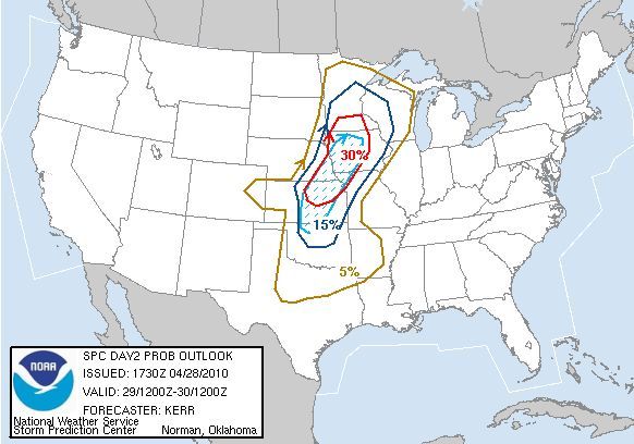
Percent probability of severe weather within 25 miles of a point -- Hatched (blue dashed area) is probability of significant severe weather within 25 miles of a point
The main threat that should occur with these storms in our area is large hail and some damaging winds. I won't rule out an isolated tornado or two, mainly in southern Minnesota (south of the cities), but the main tornado action (along with the main severe weather event) should be from Iowa down toward Kansas in the afternoon and evening.
I do not think that this will be a big outbreak in our area - more an isolated event. We could see a bigger outbreak, including tornadoes, as the system pushes eastward into Wisconsin, Iowa, Illinois, and south through Louisiana and Mississippi on Friday.
Tuesday, April 27, 2010
Nice for another day (but with a fire danger) then severe threat?
First, if you are planning on venturing out and about this evening, temps will be dropping through the 50s, eventually bottoming about around 37 for a low tonight with mainly clear skies.
We will continue to see very nice weather tomorrow, with temps higher than the 62 they were today... topping out around 66 with sunny skies. We could see some gustier winds out of the south though, to near 20 mph.
That, along with a low humidity reading, has caused the National Weather Service to put out a Fire Weather Watch for Douglas, Todd, and Morrison Counties from Noon Wednesday through 8 pm.
After tomorrow... well, it looks rainy. A chance of showers and thunderstorms is in the forecast every day and night from late Wednesday Night through the weekend (mainly showers though for the weekend, tapering off Saturday Night into Sunday).

The day that holds the most concern right now is Thursday. Right now a Slight Risk of Severe Storms is out for a sliver of the state, as you can see in the graphic, but I am cautious and would say that the southern half of the state should be on the lookout from the late afternoon through the evening. I would say the best threat would be large hail and some damaging winds. The Storm Prediction Center was not very clear AT ALL in their forecast this morning about the threat in Minnesota, but I think the main tornado threat will be more in southern Iowa through Kansas, Oklahoma and into Texas.
Highs will be around 70 Thursday, and in the lower 60s Friday through the weekend and into next week. More rain and possibly active weather as we get into the first half of next week.
We will continue to see very nice weather tomorrow, with temps higher than the 62 they were today... topping out around 66 with sunny skies. We could see some gustier winds out of the south though, to near 20 mph.
That, along with a low humidity reading, has caused the National Weather Service to put out a Fire Weather Watch for Douglas, Todd, and Morrison Counties from Noon Wednesday through 8 pm.
After tomorrow... well, it looks rainy. A chance of showers and thunderstorms is in the forecast every day and night from late Wednesday Night through the weekend (mainly showers though for the weekend, tapering off Saturday Night into Sunday).
The day that holds the most concern right now is Thursday. Right now a Slight Risk of Severe Storms is out for a sliver of the state, as you can see in the graphic, but I am cautious and would say that the southern half of the state should be on the lookout from the late afternoon through the evening. I would say the best threat would be large hail and some damaging winds. The Storm Prediction Center was not very clear AT ALL in their forecast this morning about the threat in Minnesota, but I think the main tornado threat will be more in southern Iowa through Kansas, Oklahoma and into Texas.
Highs will be around 70 Thursday, and in the lower 60s Friday through the weekend and into next week. More rain and possibly active weather as we get into the first half of next week.
Latest on The Yazoo City, MS, Tornado
Here is the latest information on the Yazoo City, MS, Tornado
Strength: EF4 with winds of 170 mph
Path Length: 149 miles
Maximum Width: 1.75 miles
Casualties: 10
What follows is the latest statement from the Jackson, MS, NWS office on the tornado.
PUBLIC INFORMATION STATEMENT
NATIONAL WEATHER SERVICE JACKSON MS
620 PM CDT MON APR 26 2010
..UPDATED INFORMATION ON LONG TRACK TORNADO PATH
NWS STORM SURVEY TEAMS FROM JACKSON AND MEMPHIS HAVE NOW
COMPLETED PRELIMINARY GROUND SURVEYS ALONG THE ENTIRE PATH
OF THE PRIMARY SUPERCELL THUNDERSTORM THAT TRACKED FROM
WEST OF TALLULAH, LOUISIANA...TO YAZOO CITY...TO NORTHEAST
OF WEST POINT...ON SATURDAY APRIL 26.
THE PRELMINARY CONCLUSION BASED ON THE GROUND SURVEYS IS
THAT A SINGLE...CONTINUOUS PATH OF TORNADIC DAMAGE WAS
PRODUCED FROM WEST OF TALLULAH TO THE EXTREME WESTERN PART
OF OKTIBBEHA COUNTY IN NORTHEAST MISSISSIPPI. THE TORNADO
APPEARED TO DISSIPATE AT THIS POINT...BUT THE STORM PRODUCED
TWO ADDITIONAL TORNADOES IN THE NWS JACKSON SERVICE AREA...
AN EF-1 IN NORTHERN OKTIBBEHA COUNTY...AND AN EF-2 IN
NORTHEAST CLAY COUNTY. INFORMATION REGARDING THESE TORNADOES
HAS BEEN PROVIDED IN EARLIER STATEMENTS.
THE MAIN LONG TRACK TORNADO WAS STRONG ALMOST FROM ITS INITIAL
STAGE OF DEVELOPMENT IN NORTHEAST LOUISIANA. EF-2 AND
EF-3 DAMAGE WAS COMMON ALL ALONG THE TORNADO'S PATH INTO
CENTRAL MISSISSIPPI...WITH TWO AREAS OF EF-4 DAMAGE IN YAZOO
AND HOLMES COUNTIES. AFTER CROSSING INTERSTATE 55...THE TORNADO
WEAKENED...WITH EF-1 AND OCCASIONAL EF-2 DAMAGE BEING COMMON
AS THE TORNADO MOVED ACROSS ATTALA COUNTY. THE TORNADO REINTENSIFIED
AS IT MOVED INTO CHOCTAW COUNTY...WITH AT LEAST HIGH END EF-3 DAMAGE
OCCURRING NORTHWEST OF THE WEIR COMMUNITY. THE TORNADO REMAINED
STRONG BEFORE RAPIDLY WEAKENING AND THEN DISSIPATING JUST AFTER
MOVING INTO OKTIBBEHA COUNTY.
HERE IS A PRELIMINARY SUMMARY OF THIS TORNADO:
BEGINNING POINT: 5 MILES W OF TALLULAH, LA 32.408N, 91.283W
AT 11:06 AM
ENDING POINT: 5.5 MILES N OF STURGIS, MS 33.430N, 89.054W
AT 1:52 PM
PATH LENGTH: 149 MILES
MAXIMUM WIDTH: 1.75 MILES
RATING: EF-4, WITH MAXIMUM WINDS OF 170 MPH
CASUALTIES: 10 TOTAL FATALITIES WITH DOZENS OF INJURIES
IT MUST BE STRESSED THAT ALL OF THIS INFORMATION IS PRELIMINARY
AND SUBJECT TO LATER ADJUSTMENT. A TORNADO OF THIS STRENGTH AND
MAGNITUDE REQUIRES A TREMENDOUS AMOUNT OF DAMAGE SURVEYS AND DATA
ANALYSIS. AN ANALYSIS OF AERIAL SURVEY INFORMATION COULD STILL
RESULT IN THE TORNADO BEING BROKEN UP INTO MORE THAN ONE PATH.
THE NWS WILL CONTINUE TO PROVIDE UPDATES AS ADDITIONAL
INFORMATION IS OBTAINED...AND IS PLANNING TO HOLD A MEDIA BRIEFING
LATER THIS WEEK TO PROVIDE A FULL ANALYSIS OF THE STORM AND THE
DAMAGE SURVEY RESULTS. ALSO...A WEBPAGE CONCERNING THIS WEATHER
EVENT...INCLUDING DAMAGE PICTURES AND MAPS...WILL BE UPDATED AT
WWW.SRH.NOAA.GOV/JAN.
THE NWS WOULD LIKE TO THANK ALL OF OUR PARTNERS IN LAW ENFORCEMENT
AND EMERGENCY MANAGEMENT FOR THEIR INVALUABLE ASSISTANCE IN
PERFORMING OUR DAMAGE SURVEYS.
Saturday, April 24, 2010
SWAW Day 5 Heat
Note: Meant to post this yesterday! Sorry!
Once again, it's Severe Weather Awareness Week here in Minnesota and Wisconsin, brought to you by the National Weather Service along with the Divisions of Homeland Security and Emergency Management. Each day a new topic of severe weather will once again be covered:
Monday: Thunderstorms, Hail, Wind and Lightning
Tuesday: Severe Weather Watches and Warnings, and How to Receive Severe Weather Information
Wednesday: Flash Floods
Thursday: Tornadoes (Including Two Tornado Drills)
Friday: Heat Waves
We will bring you this information every day from the National Weather Service, including a special post on Wednesday outlining procedures for Thursdays Tornado Drills. Today's subject is Heat Waves. We hope you find this information informative and helpful as we enter severe weather season and remember to stick with this blog for the very latest on severe weather throughout the season.
Heat wave brochure [PDF] - Courtesy of the National Weather Service - Chanhassen
Official Heat index chart [PDF] - Courtesy of the National Weather Service - Chanhassen Office
Heat Symptoms [PDF] - Courtesy of the Minnesota Department of Health
Keep Cool [PDF] - Courtesy of the Minnesota Department of Health
Hot Weather Kills [PDF] - Courtesy of the Minnesota Department of Health
More information from the National Weather Service
Minnesota's Deadliest Weather Factor Since 1990...
The second greatest number of weather fatalities in Minnesota since 1990 has been due to excessive heat. Fourteen people have died from high heat and humidity. Only flooding has killed more people in the last 18 years.
Wisconsin's Deadliest Weather Factor Since 1982...
The greatest number of weather fatalities in Wisconsin since 1982 has been due to excessive heat. 116 people have died from high heat and humidity. This total is more than tornadoes, flooding, blizzards or anything else. The 1995 summer heat waves hold the record as the number one weather-related killer in Wisconsin since it became a state in 1848. Most deaths occurred in the major urban areas in southeast Wisconsin, but there have been a number of fatalities in the rest of the state as well.
Fortunately, there were no deaths last year from excessive heat in either WIsconsin or Minnesota.
In the last 10 years, a national average of 219 people have died as a result of health problems directly related to excessive heat. Considering this death toll, the National Weather Service has stepped up its efforts to more effectively alert the general public to the hazards of heat waves.
Based on research findings, the National Weather Service devised the Heat Index (HI). It is an accurate measure of how hot it really feels when the relative humidity is added to the actual air temperature. It is important to note that since heat index values were devised for shady, light wind conditions, exposure to full sun can increase values by up to 15 degrees.
Heat disorders generally have to do with a reduction or collapse in the ability of the body to shed heat by circulatory changes and sweating. In other words, a chemical imbalance caused by too much sweating. When heat gain exceeds the level the body can remove, or when the body cannot compensate for fluids and salt lost through perspiration, the inner-core temperature of the body begins to rise and heat-related illnesses may develop. Ranging in severity, heat disorders share one common feature: the individual has over-exposed or over-excerised for his/her age and physical condition in the existing thermal environment.
Sunburn, with its ultraviolet radiation burns, can also significantly retard the ability of skin to shed excess heat.
Safety tips...
The National Weather Service will issue advisories or warnings when the heat index is expected to have a significant impact on public safety. The common guidelines for the issuance of excessive heat warnings is when the maximum daytime index is expected to reach 110 or 115, and the nighttime low temperature does not fall below 75 or 80 degrees.
Here are some tips to follow to ensure that heat-related problems do not impact you...
- Slow down. Strenuous activities should be reduced, eliminated or rescheduled to the coolest time of the day. Individuals at risk should stay in the coolest available place, not necessarily indoors. Dress for summer. Lightweight, light-colored clothing reflects heat and sunlight and helps your body maintain normal temperatures.
- Put less fuel on your inner fires. Foods such as proteins that increase metabolic heat production also increase water loss.
- Drink plenty of water or other non-alcoholic fluids. Your body needs water to keep cool. Drink plenty of fluids, even if you don't feel thirsty. However, those who suffer from epilepsy, heart, kidney or liver disease, are on fluid restrictive diets, or have a problem with fluid retention should consult a physician before increasing their consumption of fluids.
- Do not drink alcoholic beverages.
- Spend more time in air-conditioned places. Air conditioning in homes and other buildings markedly reduces danger from the heat. If you cannot afford an air conditioner, spending time each day in an air-conditioned environment during hot weather affords some protection.
- Be careful not to get too much sun. Sunburn makes the job of heat dissipation that much more difficult.
Thursday, April 22, 2010
SWAW Day 4 Tornado Safety
Once again, it's Severe Weather Awareness Week here in Minnesota and Wisconsin, brought to you by the National Weather Service along with the Divisions of Homeland Security and Emergency Management. Each day a new topic of severe weather will once again be covered:
Monday: Thunderstorms, Hail, Wind and Lightning
Tuesday: Severe Weather Watches and Warnings, and How to Receive Severe Weather Information
Wednesday: Flash Floods
Thursday: Tornadoes (Including Two Tornado Drills)
Friday: Heat Waves
We will bring you this information every day from the National Weather Service. Today's subject is Tornadoes. To go along with today's information, the National Weather Service will run two tornado drills in the area: one at 1:45 and the other at 6:55. It is asked that you at least figure out during these times what you would do in the event of an actual tornado warning. For more information on today's timeline of events, check out yesterday's post.
We hope you find this information informative and helpful as we enter severe weather season and remember to stick with this blog for the very latest on severe weather throughout the season.
From Stearns County "According to National Weather Service data, tornadoes have occurred in every Minnesota county at some time during the past 60 years. Stearns County has experienced 40 tornadoes since 1950." Click here for more from Stearns County Emergency Services
More tornado information from the NWS
Before the Tornado...
Tornado watches highlight the area where tornadoes are most likely to develop. Continue with your normal activites, but keep informed of the latest weather information and be ready to get to shelter in case tornadoes develop quickly.
In the Home...
Go to the basement if possible. Get under a table, work bench, or some other sturdy furniture to avoid falling debris. A stairwell is also a good place to hide during a tornado.
If You Cannot Get to a Basement...
Go to a small interior room on the lowest floor. Closets, bathrooms, and interior halls afford the best protection in most cases, or try to hide under a bed. Get under something sturdy or cover yourself with blankets. Stay away from windows.
In an Apartment, School or Office Building...
Move to the inner-most room on the lowest level or to a pre-designated shelter area. Stay away from windows. If in a hallway, crouch down and protect your head from flying debris. Avoid areas with glass and large roof expansions.
In a Mobile Home, Car, Truck or Other Vehicle...
Abandon these as quickly as possible. Seek a sturdy shelter or permanent structure. Remember that many deaths occur when people try to drive away in a vehicle, but get caught in the deadly winds. Avoid bridges since they act as wind tunnels.
Last year, Minnesota saw 24 tornadoes, fewer than the average since the early 90s. The strongest were two tornadoes rated EF-2, one that hit Austin on June 17, and another that hit Swift Falls on July 14. There were no deaths or injuries across the state.
Wisconsin had 16 tornadoes last year, and all were weak. Only five reached the EF-1 category, and the others were all EF-0. There were no deaths or injuries in Wisconsin last year due to tornadoes. St. Croix County had the most tornadoes in the state in 2009, with five.
SWAW Side Note: Siren Activation and Thursday's Tornado Drills
Once again, it's Severe Weather Awareness Week here in Minnesota and Wisconsin, brought to you by the National Weather Service along with the Divisions of Homeland Security and Emergency Management. Each day a new topic of severe weather is covered, but we thought that we would bring you additional information on siren activation and tomorrow's tornado drills. We hope you find this information informative and helpful as we enter severe weather season and remember to stick with this blog for the very latest on severe weather throughout the season.
Siren Activation Information
Counties and cities own the sirens, and therefore decide how and when to activate them. The National Weather Service does not sound them.
There are many different policies regarding siren activation that are used by the various cities and counties. Some will activate sirens across the entire county for tornado warnings only. Others will activate sirens countywide for tornado warnings and all severe thunderstorm warnings. Some will activate sirens across the entire county for tornado warnings and severe thunderstorms that have winds of at least 70 or 75 mph. Others will activate sirens only for portions of counties. Local officials may also sound the sirens anytime they believe severe weather is a threat, even if there is no warning from the National Weather Service.
Sirens normally sound for about three minutes, and then go silent. It is very rare to keep the sirens sounding for the entire warning, since that would cause the backup battery to run out, which would be critical in the event that power goes out. Furthermore, the siren motor will fail much more quickly if the siren sounds continuously. Some jurisdictions may repeat siren activation every few minutes.
There is no such thing as an "all-clear" for storms.
Please check with your local public safety officials for details on when warning sirens are sounded in your community.
Tornado Watch/Warning Drills
The National Weather Service, Wisconsin Emergency Management, the Minnesota Division of Homeland Security and Emergency Management, and other state, county and local agencies have come together to host Severe Weather Awareness Week activities. On Thursday, April 22nd, simulated tornado watches and warnings will be issued to test the statewide warning and communications systems. The schedule for April 22nd is as follows (all times CDT):
1:00 PM: The National Weather Service will issue a simulated tornado watch for Minnesota and Wisconsin.
1:40 PM: The National Weather Service will issue a simulated tornado warning for 9 counties of western Wisconsin (Barron, Chippewa, Dunn, Eau Claire, Pepin, Pierce, Polk, Rusk and St Croix). Note that most cities and counties will activate outdoor warning siren systems.
1:45 PM: The National Weather Service will issue a simulated tornado warning for Minnesota counties (except those in the northwestern part of the state). Note that most cities and counties will activate outdoor warning siren systems.
2:00 PM: The National Weather Service will issue an "End of Test" message using the Severe Weather Statement product. It should be stated that outdoor warning sirens will not be sounded again for this all clear, nor will there be any warning tone on NOAA Weather Radio.
6:55 PM: Another simulated tornado warning will be issued for 73 participating counties in Minnesota. Those counties not participating are: Aitkin, Carlton, Hubbard, Itasca, Kanabec, Kittson, Lincoln, Otter Tail, Pennington, Pipestone, Sibley, St. Louis, Watonwan and Wilkin. A graphic of the counties participating in the evening drill is available at http://www.severeweather.state.mn.us/Documents/Participating_Counties_Drill_Map_2010.pdf
The 6:55 PM warning will be issued by the six National Weather Service offices that serve Minnesota. It will be issued as a test of family preparedness in the home and for second shift workers.
Counties and cities own the sirens, and therefore decide how and when to activate them. The National Weather Service does not sound them.
There are many different policies regarding siren activation that are used by the various cities and counties. Some will activate sirens across the entire county for tornado warnings only. Others will activate sirens countywide for tornado warnings and all severe thunderstorm warnings. Some will activate sirens across the entire county for tornado warnings and severe thunderstorms that have winds of at least 70 or 75 mph. Others will activate sirens only for portions of counties. Local officials may also sound the sirens anytime they believe severe weather is a threat, even if there is no warning from the National Weather Service.
Sirens normally sound for about three minutes, and then go silent. It is very rare to keep the sirens sounding for the entire warning, since that would cause the backup battery to run out, which would be critical in the event that power goes out. Furthermore, the siren motor will fail much more quickly if the siren sounds continuously. Some jurisdictions may repeat siren activation every few minutes.
There is no such thing as an "all-clear" for storms.
Please check with your local public safety officials for details on when warning sirens are sounded in your community.
The National Weather Service, Wisconsin Emergency Management, the Minnesota Division of Homeland Security and Emergency Management, and other state, county and local agencies have come together to host Severe Weather Awareness Week activities. On Thursday, April 22nd, simulated tornado watches and warnings will be issued to test the statewide warning and communications systems. The schedule for April 22nd is as follows (all times CDT):
1:00 PM: The National Weather Service will issue a simulated tornado watch for Minnesota and Wisconsin.
1:40 PM: The National Weather Service will issue a simulated tornado warning for 9 counties of western Wisconsin (Barron, Chippewa, Dunn, Eau Claire, Pepin, Pierce, Polk, Rusk and St Croix). Note that most cities and counties will activate outdoor warning siren systems.
1:45 PM: The National Weather Service will issue a simulated tornado warning for Minnesota counties (except those in the northwestern part of the state). Note that most cities and counties will activate outdoor warning siren systems.
2:00 PM: The National Weather Service will issue an "End of Test" message using the Severe Weather Statement product. It should be stated that outdoor warning sirens will not be sounded again for this all clear, nor will there be any warning tone on NOAA Weather Radio.
6:55 PM: Another simulated tornado warning will be issued for 73 participating counties in Minnesota. Those counties not participating are: Aitkin, Carlton, Hubbard, Itasca, Kanabec, Kittson, Lincoln, Otter Tail, Pennington, Pipestone, Sibley, St. Louis, Watonwan and Wilkin. A graphic of the counties participating in the evening drill is available at http://www.severeweather.state.mn.us/Documents/Participating_Counties_Drill_Map_2010.pdf
The 6:55 PM warning will be issued by the six National Weather Service offices that serve Minnesota. It will be issued as a test of family preparedness in the home and for second shift workers.
Wednesday, April 21, 2010
SWAW Day 3 Flash Floods
Once again, it's Severe Weather Awareness Week here in Minnesota and Wisconsin, brought to you by the National Weather Service along with the Divisions of Homeland Security and Emergency Management. Each day a new topic of severe weather will once again be covered:
Monday: Thunderstorms, Hail, Wind and Lightning
Tuesday: Severe Weather Watches and Warnings, and How to Receive Severe Weather Information
Wednesday: Flash Floods
Thursday: Tornadoes (Including Two Tornado Drills)
Friday: Heat Waves
We will bring you this information every day from the National Weather Service, including a special post later today outlining procedures for Thursdays Tornado Drills. Today's subject is Flash Floods. We hope you find this information informative and helpful as we enter severe weather season and remember to stick with this blog for the very latest on severe weather throughout the season.
More on Flood Safety from the NWS
On a National Level...
Floods claim nearly 200 lives annually, force 300,000 persons from their homes, and result in property damage in excess of 2 billion dollars. Characteristically, 75 percent of flash flood deaths occur at night with half of the victims dying in their automobiles or other vehicles. It may be difficult to believe, but many deaths occur when persons knowingly drive around road barricades indicating the road is washed out ahead.
There were no flood-related fatalities or injuries in Minnesota or Wisconsin in 2009.
In 2008...
Wisconsin had one flood-related fatality in 2008, late on June 12th near Wales, when a man drove into a flooded area. Minnesota also had one flood-related fatality in 2008. This occurred on June 12th near Oakland when a man drove into a flooded area
In 2007...
Disastrous flooding struck southeast Minnesota and southwest Wisconsin on August 18th and 19th. Eight people died that weekeend... 7 in Minnesota and 1 in Wisconsin. Most deaths occurred in vehicles. A statewide record for 24-hour rainfall was set in Minnesota when 15.1 inches fell 1 mile south of Hokah.
Are You Prepared?
Assume a thunderstorm produces 6 inches of rain in less than 6 hours time near your community. Storms of this magnitude or greater occur several times each year in the U.S. Would you know what action to take to protect yourself and the people who depend on you for safety? After a major flood event, one of the most common quotes from the survivors of the flood is the expression they did not believe it could happen to them or in their community.
Before the Flooding...
There is nothing anyone can do to prevent the occurrence of flash flood producing rainfall. However, by striving for sound flood plain zoning, developing an emergency action plan in advance of the disaster, purchasing flood insurance at least 30 days before the flooding, and being aware of the dangers associated with extremely heavy rainfall and flooding, there is a chance of decreasing the death toll and property damage that results from flash flooding.
Tuesday, April 20, 2010
SWAW Day 2 Severe Weather Watches and Warnings and How to Receive Severe Weather Information
Once again, it's Severe Weather Awareness Week here in Minnesota and Wisconsin, brought to you by the National Weather Service along with the Divisions of Homeland Security and Emergency Management. Each day a new topic of severe weather will once again be covered:
Monday: Thunderstorms, Hail, Wind and Lightning
Tuesday: Severe Weather Watches and Warnings, and How to Receive Severe Weather Information
Wednesday: Flash Floods
Thursday: Tornadoes (Including Two Tornado Drills)
Friday: Heat Waves
We will bring you this information every day from the National Weather Service, including a special post on Wednesday outlining procedures for Thursdays Tornado Drills. Today's subject is Severe Weather Watches and Warnings, and How to Receive Severe Weather Information. We hope you find this information informative and helpful as we enter severe weather season and remember to stick with this blog for the very latest on severe weather throughout the season.
More information on dissemination services from the NWS
Watches...
Are issued when conditions are favorable for tornadoes, severe thunderstorms or flash floods. If you are in a watch area, continue with normal activities but also make plans to seek shelter if necessary.
Warnings...
Are issued when severe weather has been reported or is imminent. Seek shelter immediately if you are in or near the path of the storm. Warnings are issued by county and city names. Make sure you know the name of the county in which you live and the cities that surround you.
Advance Information...
The forecast and warning process begins one or more days ahead of time, when the threat area is determined. Hazardous weather outlooks are issued early every morning, and updated as conditions warrant.
If a Watch is Issued...
Local weather offices are staffed with extra personnel. State officials are notified and they pass the information to the county and local level. Counties and cities activate their spotter groups as the threat increases. TV and radio stations pass the word to the public.
If a Warning is Issued...
Warnings are disseminated swiftly in a multitude of ways, including TV, radio, and over the internet. Advances in technology have allowed people to receive warnings via cell phone, pager, and numerous other methods. Spotters provide important reports on the storm, and emergency officials carry out the plans that the emergency managers have developed. Updates are issued frequently until the immediate threat has ended.
Sirens...
Counties and cities own the sirens and therefore decide how and when to activate them. The National Weather Service does not sound them. There are many different policies by counties and cities. Some will activate them across the entire county for a tornado warning only. Others will activate sirens countywide for tornado warnings and all severe thunderstorm warnings. Some will activate sirens across the entire county for tornado warnings and severe thunderstorms that have winds of at least 70 or 75 mph. Others will activate sirens only for portions of counties. Also, local officials may sound the sirens anytime they believe severe weather is a threat, even if there is no warning from the National Weather Service.
Sirens normally sound about 3 minutes and then go silent. It is very rare to keep the sirens sounding for the entire warning, since that will cause the backup battery to run out, which would be critical in the event power goes out. Furthermore, the siren motor will fail much more quickly if the siren sounds continuously. Some jurisdictions may repeat siren activation every few minutes. There is no such thing as an "All Clear" for storms.
Media...
Media outlets receive the warning information and disseminate it to you, often by interrupting programming. Many television stations use a crawl and other visual means.
NOAA Weather Radio...
The tone alert feature of NOAA Weather Radio will activate specially built receivers, sounding an alarm to alert you to the danger. It sounds its alert anytime the National Weather Service issues a warning, even in the middle of the night. Make sure you have a NOAA Weather Radio, as you can not always depend on sirens, phone calls or seeing the warnings on television.
Monday, April 19, 2010
SWAW Day 1 Thunderstorms, Hail, Wind and Lightning
Once again, it's Severe Weather Awareness Week here in Minnesota and Wisconsin, brought to you by the National Weather Service along with the Divisions of Homeland Security and Emergency Management. Each day a new topic of severe weather will once again be covered:
Monday: Thunderstorms, Hail, Wind and Lightning
Tuesday: Severe Weather Watches and Warnings, and How to Receive Severe Weather Information
Wednesday: Flash Floods
Thursday: Tornadoes (Including Two Tornado Drills)
Friday: Heat Waves
We will bring you this information every day from the National Weather Service, including a special post on Wednesday outlining procedures for Thursdays Tornado Drills. Today's subject is Thunderstorms, Hail, Wind and Lightning. We hope you find this information informative and helpful as we enter severe weather season and remember to stick with this blog for the very latest on severe weather throughout the season.
Brochure from NWS with additional information
Thunderstorms...
Affect relatively small areas when compared with most other storms. The typical thunderstorm is 15 miles in diameter and lasts for 30 minutes. Despite this size, all thunderstorms are dangerous. Severe thunderstorms produce large hail or winds of at least 58 mph. Some wind gusts can exceed 100 mph and produce tornado-like damage. Many communities will sound their outdoor sirens for very damaging straight-line winds. When a severe thunderstorm threatens, stay inside a strong structure. Mobile home occupants should go to a more permanent structure.
Hail...
Is another product of thunderstorms that annually causes nearly one billion dollars in damage throughout the United States. Many of the losses are incurred by farmers. The most common diameter is pea size, but hail can be as large as golf balls and baseballs. In extreme cases, hail can reach grapefruit size. Large hail stones fall at speeds faster than 100 mph and have been known to kill people.
The largest hail stone in Minnesota last year was 3.25 inches on June 17 near Blooming Prairie.
Wisconsin's largest hailstone in 2010 was baseball size (2.75 inches), falling on June 18 across Dane County, and on July 24 in Lafayette County.
Thunderstorm Winds...
Thunderstorms can produce strong wind gusts. These straight-line winds have been known to exceed 100 mph. For this reason, you should treat severe thunderstorms just as you would tornadoes. Move to an appropriate shelter if you're in the path of the storm.
The strong outrush of wind from a thunderstorm is often called a downburst. One of the primary causes is rain-cooled air, which accelerates rapidly downward, producing a potentially damaging gust of wind.
Strong downbursts are often mistaken for tornadoes. They can produce extensive damage and are often accompanied by a roaring sound similar to that of a tornado. Downbursts can easily overturn mobile homes, tear roofs off of houses, and topple trees. People who are camping are especially vulnerable, due to trees toppling on their camp sites.
The highest thunderstorm wind gust last year in Wisconsin was 95 mph, near Garfield on August 28.
The highest thunderstorm wind gust in Minnesota last year was 100 mph, occurring on July 14th near Spicer.
Lightning...
Every thunderstorm produces lightning, which on a national basis kills more people than tornadoes in a given year.
Lightning kills around 100 Americans annually, with about 300 injuries. In Wisconsin and Minnesota, there have been many deaths and injuries over the years, most in areas such as camp grounds, although people have been injured indoors when talking on the phone.
The following are some lightning safety tips...
Myth: If it's not raining, there is no danger from lightning.
Fact: Lightning often strikes away from heavy rainfall, and may occur as far as 10 miles away from any rainfall.
Myth: Rubber soles of shoes or rubber tires on a car will protect you from being injured by lightning.
Fact: Rubber provides no protection from lightning. However, the steel frame of a hard-topped vehicle provides increased protection from lightning (if you are not touching metal in the car).
Myth: People struck by lightning carry an electrical charge and should not be touched.
Fact: Lightning-strike victims carry no electrical charge and should be attended to immediately.
Myth: Heat lightning occurs after very hot summer days and poses no threat.
Fact: What is referred to as "heat lightning" is actually lightning from a thunderstorm too far away for thunder to be heard. However, the storm may be moving in your direction.
Monday: Thunderstorms, Hail, Wind and Lightning
Tuesday: Severe Weather Watches and Warnings, and How to Receive Severe Weather Information
Wednesday: Flash Floods
Thursday: Tornadoes (Including Two Tornado Drills)
Friday: Heat Waves
We will bring you this information every day from the National Weather Service, including a special post on Wednesday outlining procedures for Thursdays Tornado Drills. Today's subject is Thunderstorms, Hail, Wind and Lightning. We hope you find this information informative and helpful as we enter severe weather season and remember to stick with this blog for the very latest on severe weather throughout the season.
Brochure from NWS with additional information
Thunderstorms...
Affect relatively small areas when compared with most other storms. The typical thunderstorm is 15 miles in diameter and lasts for 30 minutes. Despite this size, all thunderstorms are dangerous. Severe thunderstorms produce large hail or winds of at least 58 mph. Some wind gusts can exceed 100 mph and produce tornado-like damage. Many communities will sound their outdoor sirens for very damaging straight-line winds. When a severe thunderstorm threatens, stay inside a strong structure. Mobile home occupants should go to a more permanent structure.
Hail...
Is another product of thunderstorms that annually causes nearly one billion dollars in damage throughout the United States. Many of the losses are incurred by farmers. The most common diameter is pea size, but hail can be as large as golf balls and baseballs. In extreme cases, hail can reach grapefruit size. Large hail stones fall at speeds faster than 100 mph and have been known to kill people.
The largest hail stone in Minnesota last year was 3.25 inches on June 17 near Blooming Prairie.
Wisconsin's largest hailstone in 2010 was baseball size (2.75 inches), falling on June 18 across Dane County, and on July 24 in Lafayette County.
Thunderstorm Winds...
Thunderstorms can produce strong wind gusts. These straight-line winds have been known to exceed 100 mph. For this reason, you should treat severe thunderstorms just as you would tornadoes. Move to an appropriate shelter if you're in the path of the storm.
The strong outrush of wind from a thunderstorm is often called a downburst. One of the primary causes is rain-cooled air, which accelerates rapidly downward, producing a potentially damaging gust of wind.
Strong downbursts are often mistaken for tornadoes. They can produce extensive damage and are often accompanied by a roaring sound similar to that of a tornado. Downbursts can easily overturn mobile homes, tear roofs off of houses, and topple trees. People who are camping are especially vulnerable, due to trees toppling on their camp sites.
The highest thunderstorm wind gust last year in Wisconsin was 95 mph, near Garfield on August 28.
The highest thunderstorm wind gust in Minnesota last year was 100 mph, occurring on July 14th near Spicer.
Lightning...
Every thunderstorm produces lightning, which on a national basis kills more people than tornadoes in a given year.
Lightning kills around 100 Americans annually, with about 300 injuries. In Wisconsin and Minnesota, there have been many deaths and injuries over the years, most in areas such as camp grounds, although people have been injured indoors when talking on the phone.
The following are some lightning safety tips...
- All thunderstorms produce lightning. It is surprising that so many people are not aware of this.
- Get inside a building or enclosed vehicle. Many fatalities occur when the warning signs are ignored.
- If caught in an open area with lightning all around, crouch down immediately! Put your hands on your knees but do not lie down on the ground.
- Do not use a telephone or electrical appliance. A nearby lightning strike can travel through the phone or power lines right into the home.
- Avoid seeking shelter beneath lone trees.
Myth: If it's not raining, there is no danger from lightning.
Fact: Lightning often strikes away from heavy rainfall, and may occur as far as 10 miles away from any rainfall.
Myth: Rubber soles of shoes or rubber tires on a car will protect you from being injured by lightning.
Fact: Rubber provides no protection from lightning. However, the steel frame of a hard-topped vehicle provides increased protection from lightning (if you are not touching metal in the car).
Myth: People struck by lightning carry an electrical charge and should not be touched.
Fact: Lightning-strike victims carry no electrical charge and should be attended to immediately.
Myth: Heat lightning occurs after very hot summer days and poses no threat.
Fact: What is referred to as "heat lightning" is actually lightning from a thunderstorm too far away for thunder to be heard. However, the storm may be moving in your direction.
Monday, April 5, 2010
Tornado Potential Over Southern Iowa, Northern Missouri
We are watching a potentially dangerous situation for later today over southern Iowa and northern Missouri later today. The Stprm Prediction Center has that area in a 10% hatched tornado threat, meaning that storms later today have the potential of producing strong, large tornadoes along with very large hail and damaging winds, and with the latest update had seriously considered upgrading the area to a Moderate Risk of severe storms. It looks like it would be a perfect day for VORTEX 2 if they were already going for the year.
Follow me on Twitter @weathrlver
Follow me on Twitter @weathrlver
Thursday, March 25, 2010
Quickly warming back up... Spring Fever by middle next week
After a relatively cool day today (well, cool compared to what we have had lately) the weather will quickly warm back up, reaching a high of 54 on Friday with a mix of clouds and sun along with blustery southeast winds.
A chance of rain moves in Friday Night into Saturday, leaving highs around 52 on Saturday. Rain should push out by Sunday, leaving it sunny through at least the middle of next week. Highs will continue to increase, lower 50s on Sunday, middle 50s on Monday, around 60 on Tuesday, before leaping into (at least) the middle 60s for Wednesday and Thursday.
There is a chance that we could see highs around 70 by the end of the week, along with a chance of thunderstorms! Spring fever will definitely be in swing by this time next week, and we will be looking back at March as only the seventh time in St. Cloud history that we have gone without any snow falling, along with one of the top 10 warmest Marches ever.
Thursday, March 18, 2010
Photos of the Mississippi Ice Jam, Sauk River Flooding, and the Hennen's FAIL!
The girlfriend and I went on an adventure today to the site of the Mississippi Ice Jam along with a park where the Sauk River is flooding. Here are some of the pictures we captured (links will take you to the whole photo album):
Mississippi Ice Jam (in the Rice/Watab area) (MANY More at http://s938.photobucket.com/albums/ad224/weathrlver/Mississippi%20Ice%20Jam%202010/


The Sartell Dam

The Sauk River (more at http://s938.photobucket.com/albums/ad224/weathrlver/Sauk%20River%20Flooding%202010/)


The Hennen's Fail (taken at 3:07 while the temp was around 60... it said it was -48!)

Mississippi Ice Jam (in the Rice/Watab area) (MANY More at http://s938.photobucket.com/albums/ad224/weathrlver/Mississippi%20Ice%20Jam%202010/
The Sartell Dam
The Sauk River (more at http://s938.photobucket.com/albums/ad224/weathrlver/Sauk%20River%20Flooding%202010/)
The Hennen's Fail (taken at 3:07 while the temp was around 60... it said it was -48!)
URGENT: Flood Warning on Mississsippi due to Major Ice Jam near Watab
I've already been down there and checked out the ice dam. I am currently working on pictures and will have them up ASAP.
FLOOD WARNING
NATIONAL WEATHER SERVICE TWIN CITIES/CHANHASSEN MN
1048 AM CDT THU MAR 18 2010

MNC009-145-191530-
/O.NEW.KMPX.FA.W.0010.100318T1548Z-100319T1530Z/
/00000.0.IJ.000000T0000Z.000000T0000Z.000000T0000Z.OO/
STEARNS MN-BENTON MN-
1048 AM CDT THU MAR 18 2010

THE NATIONAL WEATHER SERVICE IN THE TWIN CITIES HAS ISSUED A

* FLOOD WARNING FOR ICE JAM FLOODING IN...
  EAST CENTRAL STEARNS COUNTY IN CENTRAL MINNESOTA...
  WESTERN BENTON COUNTY IN CENTRAL MINNESOTA...

* UNTIL 1030 AM CDT FRIDAY

* AT 1030 AM CDT...EMERGENCY MANAGEMENT AND LAW ENFORCEMENT REPORTED
  A SIGNIFICANT ICE JAM ALONG THE MISSISSIPPI RIVER FROM THE NORTH
  SIDE OF SARTELL NORTHWARD THROUGH PINE POINT. THIS IS CAUSING
  WATER TO BACK UP ALONG THE RIVER AND INTO LITTLE ROCK LAKE. LAW
  ENFORCEMENT HAS REPORTED SEVERAL HOMES ON PINE POINT ARE ALREADY
  CLOSE TO BEING IMPACTED. FLOODING IS LIKELY IN IMMEDIATE LOWLAND
  AREAS ALONG THE RIVER AND POSSIBLY ALONG HARRIS CHANNEL AND INTO
  LITTLE ROCK LAKE. IF THE ICE JAM WERE TO BREAK ABRUPTLY...FLOODING
  IS LIKELY TO OCCUR FURTHER DOWNSTREAM ALONG THE MISSISSIPPI
  CHANNEL THROUGH SARTELL AND POSSIBLY INTO THE NORTH SIDE OF ST
  CLOUD. CONSIDERING THE EXTENT OF THIS ICE JAM AND LITTLE ICE
  MOVEMENT HAVING BEEN NOTICED THUS FAR...THIS ICE JAM MAY BE A
  PROLONGED EVENT.

* SOME LOCATIONS THAT ARE LIKELY TO EXPERIENCE FLOODING
  INCLUDE...PINE POINT...LITTLE ROCK LAKE...WATAB...SARTELL AND SAUK
  RAPIDS.

PRECAUTIONARY/PREPAREDNESS ACTIONS...

RESIDENTS NEAR THE MISSISSIPPI RIVER FROM JUST SOUTH OF RICE TO
THE NORTH SIDE OF ST CLOUD SHOULD ACT NOW FOR POSSIBLE FLOODING
AS THE ICE MOVES THROUGH THE RIVER.
Latest on the Sauk... Warm through tomorrow before a change...
The Sauk River is currently quickly approaching 7', a foot above flood stage. It is expected to level off there sometime within the next 24-36 hours before slowly going back down. While the forecast has the waters slowly receding, there is always the possibility that a surge could send the river back up. Seven feet is a moderate flood for the Sauk.
Meanwhile, the Red River to the north is in moderate to major flood stage in the Fargo and Grand Forks area. It is expected to crest at 38' in Fargo by the end of the weekend (3' below last years record crest) and at 48' in Grand Forks (just over a foot below last years record crest).
Most of the snow has already melted off, and the last bits of it (besides the huge mounds) should be gone by the end of the week. We reached a high of 53 on Wednesday, but should approach 60 Thursday.
After that, temps (and somewhat the weather) take a downturn. We will see a system that comes in from the north, bringing temps back to the 30s and lower 40s on Friday. A snow chance that was in the forecast has been taken out, as it looks like the precipitation will stay mainly south of the Twin Cities and mostly affect areas like Iowa and Kansas. We'll get back into the 40s next week before a mix bag of precipitation (rain/snow/freezing rain/sleet) moves in Tuesday through Wednesday. After that, trends show a very slow warm up, with maybe a rain chance for the end of the month.
Tuesday, March 16, 2010
URGENT: Sauk River to spill over banks later today... Moderate Flooding Expected

River depth and expected flood forecast as of 10 AM Tuesday by the NWS
The Sauk River unexpectedly rose a foot overnight, leaving it precariously just below flood stage this morning. It is expected that the Sauk will rise over the banks later today before possibly cresting around 7.0' on Thursday. A depth of 7' is considered a "Moderate Flood" for the river, and a good foot above flood stage. A Flood Warning in now in effect until further notice for the Sauk River in St. Cloud.
BULLETIN - IMMEDIATE BROADCAST REQUESTED
FLOOD WARNING
NATIONAL WEATHER SERVICE TWIN CITIES/CHANHASSEN MN
1151 AM CDT TUE MAR 16 2010
...FORECAST FLOODING CHANGED FROM MINOR TO MODERATE SEVERITY FOR THE
FOLLOWING RIVERS IN MINNESOTA...
SAUK RIVER AT ST CLOUD AFFECTING STEARNS COUNTY
THE NATIONAL WEATHER SERVICE WILL MONITOR THIS DEVELOPING SITUATION AND ISSUE FOLLOWUP STATEMENTS AS CONDITIONS OR FORECASTS CHANGE.
PRECAUTIONARY/PREPAREDNESS ACTIONS...
DO NOT DRIVE CARS THROUGH FLOODED AREAS. TURN AROUND...DON'T DROWN.
STAY TUNED TO NOAA WEATHER RADIO OR YOUR LOCAL RADIO OR TV STATION
FOR THE LATEST INFORMATION CONCERNING THIS FLOOD EVENT.
&&
1151 AM CDT TUE MAR 16 2010
...FORECAST FLOODING INCREASED FROM MINOR TO MODERATE SEVERITY...
THE FLOOD WARNING CONTINUES FOR
THE SAUK RIVER AT ST CLOUD.
* UNTIL FURTHER NOTICE.
* AT 11:15 AM TUESDAY THE STAGE WAS 5.9 FEET.
* MODERATE FLOODING IS FORECAST.
* FLOOD STAGE IS 6.0 FEET.
* FORECAST...RISE ABOVE FLOOD STAGE BY THIS AFTERNOON AND CONTINUE TO
RISE TO NEAR 7.0 FEET BY THURSDAY MARCH 18TH EARLY AFTERNOON.
* IMPACT...AT 6.0 FEET...TWO HOMES ALONG THE RIVER MAY EXPERIENCE
FLOODING.
* FLOOD HISTORY...THIS CREST COMPARES TO A PREVIOUS CREST OF 7.2 FEET
ON APR 25 2001.
Monday, March 15, 2010
ALERT: Flood Warning for the Sauk River until further notice... Minor Flooding Expected

Current hydrograph for the Sauk River
FLOOD STATEMENT
NATIONAL WEATHER SERVICE TWIN CITIES/CHANHASSEN MN
224 PM CDT MON MAR 15 2010

...THE FLOOD WARNING CONTINUES FOR THE FOLLOWING RIVERS IN
MINNESOTA AND WISCONSIN...

 MINNESOTA RIVER AT MONTEVIDEO AFFECTING CHIPPEWA...LAC QUI PARLE...
 RENVILLE AND YELLOW MEDICINE COUNTIES
 MINNESOTA RIVER AT GRANITE FALLS AFFECTING CHIPPEWA...RENVILLE AND
 YELLOW MEDICINE COUNTIES
 MINNESOTA RIVER AT HENDERSON AFFECTING LE SUEUR...SCOTT AND SIBLEY
 COUNTIES
 MINNESOTA RIVER NEAR JORDAN AFFECTING CARVER AND SCOTT COUNTIES
 MINNESOTA RIVER AT SHAKOPEE AFFECTING CARVER...HENNEPIN AND SCOTT
 COUNTIES
 MINNESOTA RIVER AT SAVAGE AFFECTING DAKOTA...HENNEPIN AND SCOTT
 COUNTIES
 MISSISSIPPI RIVER AT ST PAUL AFFECTING DAKOTA...RAMSEY AND
 WASHINGTON COUNTIES
 MISSISSIPPI RIVER NEAR HASTINGS L/D 2 AFFECTING DAKOTA...WASHINGTON
 AND PIERCE COUNTIES
 CROW RIVER AT ROCKFORD MN AFFECTING HENNEPIN AND WRIGHT COUNTIES
 SOUTH FORK CROW RIVER BELOW MAYER AFFECTING CARVER COUNTY
 SOUTH FORK CROW RIVER AT DELANO MN AFFECTING WRIGHT COUNTY
 LONG PRAIRIE RIVER AT LONG PRAIRIE AFFECTING TODD COUNTY
 MIDDLE FORK ZUMBRO RIVER AT PINE ISLAND AFFECTING GOODHUE COUNTY
 MINNESOTA RIVER AT NEW ULM AFFECTING BLUE EARTH...BROWN AND
 NICOLLET COUNTIES
 COTTONWOOD RIVER AT NEW ULM AFFECTING BLUE EARTH...BROWN AND
 NICOLLET COUNTIES
 REDWOOD RIVER NEAR REDWOOD FALLS AFFECTING REDWOOD COUNTY
 SAUK RIVER AT ST CLOUD AFFECTING STEARNS COUNTY


.AN WEAK UPPER LEVEL SYSTEM WILL ROTATE ACROSS WESTERN MINNESOTA
TODAY. A SECOND UPPER LEVEL SYSTEM WILL DIVE SOUTH ACROSS THE REGION
ON TUESDAY. BOTH OF THESE SYSTEMS WILL CAUSE SCATTERED AREAS OF
LIGHT RAIN ACROSS MINNESOTA AND PORTIONS OF WEST CENTRAL
WISCONSIN. HOWEVER ONLY LIGHT ACCUMULATIONS OF LESS THAN A TENTH
OF AN INCH IS EXPECTED AT THIS TIME. HENCE THE PRECIPITATION WILL
HAVE LITTLE TO NO IMPACT TO THE RIVER FORECASTS.

FOR AREAS THAT DO STILL HAVE A SNOWPACK WHICH IS MAINLY THE
WESTERN HALF OF MINNESOTA...TEMPERATURES WILL CONTINUE TO PLAY
A ROLE IN THE MELT. HIGHS ON TUESDAY WILL RANGE IN THE LOWER
TO MID 40 ACROSS CENTRAL AND WESTERN MINNESOTA. TEMPERATURES ON
WEDNESDAY WILL BE WARMER WITH HIGHS AROUND 50.OVERNIGHT LOWS TONIGHT
WILL DROP INTO THE LOWER AND MID 30S WITH UPPER 20S EXPTED FOR
TUESDAY NIGHT. THE WARM TEMPERATURES DURING THE DAY TIME HOURS WILL
CONTINUE TO HELP MELT THE SNOWPACK.

ICE AND DEBRIS JAMS REMAIN A CONCERN AS THIS EVENT UNFOLDS.

PRECAUTIONARY/PREPAREDNESS ACTIONS...

IF YOU OBSERVE AN ICE OR DEBRIS JAM PLEASE REPORT THIS TO
YOUR LOCAL LAW ENFORCEMENT AND THE NATIONAL WEATHER
SERVICE IMMEDIATELY. YOU CAN EMAIL REPORTS DIRECTLY TO
THE NWS VIA MPX.SPOTTER@NOAA.GOV.

STAY TUNED TO NOAA WEATHER RADIO OR YOUR LOCAL RADIO OR TV STATION
FOR THE LATEST INFORMATION CONCERNING THIS FLOOD EVENT.

FOR MORE INFORMATION PLEASE REFERENCE THE SPRING FLOOD MONITOR AT
WWW.CRH.NOAA.GOV/MPX/?N=SPRINGFLOODING
ALL LOWER CASE

DO NOT DRIVE CARS THROUGH FLOODED AREAS.

&&

MNC145-170123-
/O.CON.KMPX.FL.W.0017.100320T0000Z-000000T0000Z/
/STCM5.1.SM.100320T0000Z.100322T0600Z.000000T0000Z.NO/
224 PM CDT MON MAR 15 2010

THE FLOOD WARNING CONTINUES FOR
 THE SAUK RIVER AT ST CLOUD.
* AT  1:15 PM MONDAY THE STAGE WAS 4.7 FEET.
* MINOR FLOODING IS FORECAST.
* FLOOD STAGE IS 6.0 FEET.
* FORECAST...RISE ABOVE FLOOD STAGE BY FRIDAY EVENING MARCH 19TH AND CONTINUE
 TO  RISE TO NEAR 6.3 FEET BY MONDAY MORNING MARCH 22ND. ADDITIONAL
 RISES ARE POSSIBLE THEREAFTER.
* IMPACT...AT 6.0 FEET...TWO HOMES ALONG THE RIVER MAY EXPERIENCE
 FLOODING.
* FLOOD HISTORY...THIS LEVEL COMPARES TO A PREVIOUS CREST OF 8.2 FEET
 ON MAR 27 2009.
Sunday, March 14, 2010
Continued chances of rain before sun comes back... Latest flooding information (including the Sauk, Mississippi, and Red Rivers)
Overnight tonight we will see a chance of light rain with areas of fog, lows reaching 36. Sunday will see fog early, cloudy through the day and high of 50. Rain chances again Monday and Tuesday with highs in the upper 40s around 50 before the sun breaks out for Wednesday/Thursday and highs get into the lower 50s. Rain comes back into the forecast Friday, with the chance of some s*n*o*w on Saturday.
Here is a list of all the Flood Advisories out for the Twin Cities watch area:
Flood Warnings (all until further notice unless otherwise noted):
An update on the Sauk River... I would expected a Watch/Warning to be issued within the next few days. According to NWS forecasts, the Sauk River near St. Cloud is expected to approach Minor Flood Stage by the end of next week. Meanwhile, the Mississippi at St. Cloud State will also be approaching Action Stage by the end of the week. As the week goes on I will attempt to bring pictures/video from the rivers as the Spring Flooding Season continues.
And for those up in the Red River Valley, the NWS Grand Forks has also set up a Flood Briefing Page. The Red River is expected to reach Major Flood Stage along its entire path, including Wahpeton, Fargo, and Grand Forks, and could approach the historic levels set just last year.
Here is a list of all the Flood Advisories out for the Twin Cities watch area:
Flood Warnings (all until further notice unless otherwise noted):
- SCOTT COUNTY UNTIL 230 PM CDT SUNDAY DUE TO ICE JAMS AND SNOW MELT
- MINNESOTA RIVER AT MONTEVIDEO AFFECTING CHIPPEWA...LAC QUI PARLE...RENVILLE AND YELLOW MEDICINE COUNTIES
- MINNESOTA RIVER AT HENDERSON AFFECTING LE SUEUR...SCOTT AND SIBLEY COUNTIES
- MINNESOTA RIVER NEAR JORDAN AFFECTING CARVER AND SCOTT COUNTIES
- MINNESOTA RIVER AT SHAKOPEE AFFECTING CARVER...HENNEPIN AND SCOTT COUNTIES
- MINNESOTA RIVER AT SAVAGE AFFECTING DAKOTA...HENNEPIN AND SCOTT COUNTIES
- COTTONWOOD RIVER AT NEW ULM AFFECTING BLUE EARTH...BROWN AND NICOLLET COUNTIES
- CROW RIVER AT ROCKFORD MN AFFECTING HENNEPIN AND WRIGHT COUNTIES
- SOUTH FORK CROW RIVER BELOW MAYER AFFECTING CARVER COUNTY
- SOUTH FORK CROW RIVER AT DELANO MN AFFECTING WRIGHT COUNTY
- MINNESOTA RIVER AT GRANITE FALLS AFFECTING CHIPPEWA...RENVILLE AND YELLOW MEDICINE COUNTIES
- MINNESOTA RIVER AT NEW ULM AFFECTING BLUE EARTH...BROWN AND NICOLLET COUNTIES
- MINNESOTA RIVER AT MANKATO AFFECTING BLUE EARTH AND NICOLLET COUNTIES
- MINNESOTA RIVER AT GRANITE FALLS AFFECTING CHIPPEWA...RENVILLE AND YELLOW MEDICINE COUNTIES
- MINNESOTA RIVER AT MANKATO AFFECTING BLUE EARTH AND NICOLLET COUNTIES
- MISSISSIPPI RIVER NEAR HASTINGS L/D 2 AFFECTING DAKOTA...WASHINGTON AND PIERCE COUNTIES
- LONG PRAIRIE RIVER AT LONG PRAIRIE AFFECTING TODD COUNTY
An update on the Sauk River... I would expected a Watch/Warning to be issued within the next few days. According to NWS forecasts, the Sauk River near St. Cloud is expected to approach Minor Flood Stage by the end of next week. Meanwhile, the Mississippi at St. Cloud State will also be approaching Action Stage by the end of the week. As the week goes on I will attempt to bring pictures/video from the rivers as the Spring Flooding Season continues.
And for those up in the Red River Valley, the NWS Grand Forks has also set up a Flood Briefing Page. The Red River is expected to reach Major Flood Stage along its entire path, including Wahpeton, Fargo, and Grand Forks, and could approach the historic levels set just last year.
Friday, March 12, 2010
Dense Fog Advisory through 9 AM -- More Rain through Weekend -- Latest Flood Watches/Warnings

Look! We have Lake Front Property for the next few weeks!
Once again, we have a Dense Fog Advisory out until 9 AM like we have had most days this past week. All the rain/melting snow along with temps staying above freezing (allowing more melting) is creating the endless dense fog-at-night situation for the moment. Complete advisory at the bottom of post.
I actually have some good news on the rain front! We should experience some more periods of drizzle and rain through the rest of the weekend, but then I think we will shed the rain and clouds and bring some SUNSHINE for next week! Woo! And with that will come warm(er) temps, with highs reaching the lower 50s by Tuesday. Temps over the weekend, though, should be in the middle 40s for highs.
Looking ahead (though I really don't want to), we see a possibility of some snow mixing back in next weekend. Take it with a grain of salt, as I don't want to put any trust in it at the moment.
Tonight Dense fog and drizzle, 35. Saturday Drizzle, early fog, 46. Sat Night Drizzle and fog likely, 36. Sunday Rain possible 47. Monday Mix of clouds and sun, 47.
Steams and rivers continue to rise, causing A LOT of Flood Watches and Warnings in the area. This is the list I could come up with (I may have accidentally left out locations -- there are just SO MANY at the moment!). Even though the Sauk is not listed, we need to watch it closely... and probably the Mississippi River shortly.
Flood Warning (all until further notice unless noted):
- NORTH CENTRAL SCOTT COUNTY IN EAST CENTRAL MINNESOTA UNTIL 700 AM CST SATURDAY DUE TO AN ICE JAM ON SAND CREEK (INTERESTS FROM JORDAN TO CARVER SHOULD BE AWARE OF RIVER RISES)
- MINNESOTA RIVER AT SAVAGE AFFECTING DAKOTA...HENNEPIN AND SCOTT COUNTIES
- CROW RIVER AT ROCKFORD MN AFFECTING HENNEPIN AND WRIGHT COUNTIES
- SOUTH FORK CROW RIVER BELOW MAYER AFFECTING CARVER COUNTY
- SOUTH FORK CROW RIVER AT DELANO MN AFFECTING WRIGHT COUNTY
- MINNESOTA RIVER AT MONTEVIDEO AFFECTING CHIPPEWA...LAC QUI PARLE...RENVILLE AND YELLOW MEDICINE COUNTIES
- MINNESOTA RIVER AT NEW ULM AFFECTING BLUE EARTH...BROWN AND NICOLLET COUNTIES
- MINNESOTA RIVER AT HENDERSON AFFECTING LE SUEUR...SCOTT AND SIBLEY COUNTIES
- MINNESOTA RIVER NEAR JORDAN AFFECTING CARVER AND SCOTT COUNTIES
- MINNESOTA RIVER AT SHAKOPEE AFFECTING CARVER...HENNEPIN AND SCOTT COUNTIES
- COTTONWOOD RIVER AT NEW ULM AFFECTING BLUE EARTH...BROWN AND NICOLLET COUNTIES
- MINNESOTA RIVER AT GRANITE FALLS AFFECTING CHIPPEWA...RENVILLE AND
YELLOW MEDICINE COUNTIES - MINNESOTA RIVER AT MANKATO AFFECTING BLUE EARTH AND NICOLLET COUNTIES
- MINNESOTA RIVER AT GRANITE FALLS AFFECTING CHIPPEWA...RENVILLE AND YELLOW MEDICINE COUNTIES
- MINNESOTA RIVER AT NEW ULM AFFECTING BLUE EARTH...BROWN AND NICOLLET COUNTIES
- MINNESOTA RIVER AT MANKATO AFFECTING BLUE EARTH AND NICOLLET COUNTIES
- MINNESOTA RIVER NEAR JORDAN AFFECTING CARVER AND SCOTT COUNTIES
- MINNESOTA RIVER AT SHAKOPEE AFFECTING CARVER...HENNEPIN AND SCOTT COUNTIES
URGENT - WEATHER MESSAGE
NATIONAL WEATHER SERVICE TWIN CITIES/CHANHASSEN MN
930 PM CST FRI MAR 12 2010

...ANOTHER ROUND OF DENSE FOG FOR MUCH OF SOUTHERN AND CENTRAL
MINNESOTA...

.LIGHT WINDS AND ABUNDANT MOISTURE DUE TO CONTINUED MILD
TEMPERATURES AND MELTING SNOW WILL PRODUCE ANOTHER FOGGY NIGHT
OVER MUCH OF THE AREA INTO SATURDAY MORNING. THE FOG WILL REDUCE
VISIBILITIES TO BELOW A QUARTER MILE IN MANY LOCATIONS...WITH
LOCAL VISIBILITIES NEAR ZERO.

MNZ041-042-047>049-054>059-064>068-073>075-082-083-091-092-131130-
/O.NEW.KMPX.FG.Y.0011.100313T0400Z-100313T1500Z/
DOUGLAS-TODD-STEVENS-POPE-STEARNS-LAC QUI PARLE-SWIFT-CHIPPEWA-
KANDIYOHI-MEEKER-WRIGHT-YELLOW MEDICINE-RENVILLE-MCLEOD-SIBLEY-
CARVER-REDWOOD-BROWN-NICOLLET-WATONWAN-BLUE EARTH-MARTIN-
FARIBAULT-
INCLUDING THE CITIES OF...ALEXANDRIA...LONG PRAIRIE...MORRIS...
GLENWOOD...ST. CLOUD...MADISON...BENSON...MONTEVIDEO...WILLMAR...
LITCHFIELD...MONTICELLO...GRANITE FALLS...OLIVIA...HUTCHINSON...
GAYLORD...CHASKA...REDWOOD FALLS...NEW ULM...ST. PETER...
ST. JAMES...MANKATO...FAIRMONT...BLUE EARTH
930 PM CST FRI MAR 12 2010

...DENSE FOG ADVISORY IN EFFECT UNTIL 9 AM CST SATURDAY...

THE NATIONAL WEATHER SERVICE IN TWIN CITIES/CHANHASSEN HAS ISSUED
A DENSE FOG ADVISORY...WHICH IS IN EFFECT UNTIL 9 AM CST
SATURDAY.

* VISIBILITY...WIDESPREAD VISIBILITY OF ONE QUARTER MILE OR LESS.

* IMPACTS...LOW VISIBILITY MAY MAKE DRIVING HAZARDOUS.

PRECAUTIONARY/PREPAREDNESS ACTIONS...

A DENSE FOG ADVISORY MEANS VISIBILITIES WILL FREQUENTLY BE
REDUCED TO LESS THAN ONE QUARTER MILE. IF DRIVING...SLOW DOWN...
USE YOUR HEADLIGHTS...AND LEAVE PLENTY OF DISTANCE AHEAD OF YOU.
Thursday, March 11, 2010
Flood Watches and Warnings
There will be more on this later tonight and in future days, but currently:
Flood Warning in effect for the Minnesota (at Montevideo, Henderson, Savage), Crow (at Rockford), and South Fork Crow (at Delano, below Mayer) Rivers
Flood Watch in effect for the Minnesota River at Granite Falls, New Ulm, Mankato, Jordan, and Shakopee
All watches and warnings are until further notice. More later.
Wednesday, March 10, 2010
Dense Fog Advisory through 9 AM Thursday... Rain through Saturday... Watch for Flooding

NWS Chanhassen Watches/Warnings as of 3 PM Wednesday... Gray is Dense Fog Advisory... Lime green is Flood Warning... Dark green is Flood Watch
A series of storms will be affecting the area throughout the beginning of the weekend, leading to many days with periods of rain over the whole area. By the end of the day on Saturday, a half an inch to an inch of rain is possible throughout most of the area from the systems.
These systems will keep the temps above freezing during both the day and night, with highs in the lower to middle 40s and lows in the middle to upper 30s. This will allow for continued rapid snow melt, and I would not be surprised if most snow (except for larger piles) will be melted away by the end of the weekend. One thing we will have to watch out for is rising rivers, especially along the Sauk locally. Meanwhile, a Flood Watch has already been issued for the South Fork Crow River below the town of Mayer affecting Carver County due to the rain and melting conditions.
A Dense Fog Advisory is in effect for parts of Minnesota, including Stearns County, until 9 AM Thursday. Check the statement below for the details.
Tonight Rain and Fog 35. Thursday Rain, especially after noon, and Fog 43. Thursday Night More Rain 36. Friday Continued Rainy 45.
URGENT - WEATHER MESSAGE...CORRECTED HEADLINE
NATIONAL WEATHER SERVICE TWIN CITIES/CHANHASSEN MN
210 PM CST WED MAR 10 2010

...DENSE FOG ADVISORY FOR MUCH OF WEST CENTRAL AND SOUTH CENTRAL
MINNESOTA THROUGH TONIGHT...

.A DENSE FOG ADVISORY REMAINS IN EFFECT THROUGH TONIGHT FOR MUCH
OF WEST CENTRAL AND SOUTH CENTRAL MINNESOTA...GENERALLY WEST OF A
LINE FROM SAUK CENTRE...TO HUTCHINSON...TO NORTHFIELD TO RED WING.
VISIBILITIES OF A QUARTER OF A MILE OR LESS WILL PERSIST ACROSS
MUCH OF THE AREA TONIGHT. POCKETS OF NEAR ZERO VISIBILITY ARE
POSSIBLE... ESPECIALLY NEAR THE IOWA BORDER AND THE INTERSTATE 90
CORRIDOR.

MNZ047>049-054>058-064>067-073>075-082>085-091>093-110415-
/O.EXT.KMPX.FG.Y.0009.000000T0000Z-100311T1500Z/
STEVENS-POPE-STEARNS-LAC QUI PARLE-SWIFT-CHIPPEWA-KANDIYOHI-
MEEKER-YELLOW MEDICINE-RENVILLE-MCLEOD-SIBLEY-REDWOOD-BROWN-
NICOLLET-WATONWAN-BLUE EARTH-WASECA-STEELE-MARTIN-FARIBAULT-
FREEBORN-
INCLUDING THE CITIES OF...MORRIS...GLENWOOD...ST. CLOUD...
MADISON...BENSON...MONTEVIDEO...WILLMAR...LITCHFIELD...
GRANITE FALLS...OLIVIA...HUTCHINSON...GAYLORD...REDWOOD FALLS...
NEW ULM...ST. PETER...ST. JAMES...MANKATO...WASECA...OWATONNA...
FAIRMONT...BLUE EARTH...ALBERT LEA
210 PM CST WED MAR 10 2010

...DENSE FOG ADVISORY NOW IN EFFECT UNTIL 9 AM CST THURSDAY...

THE DENSE FOG ADVISORY IS NOW IN EFFECT UNTIL 9 AM CST THURSDAY.

* VISIBILITY...WIDESPREAD ONE QUARTER OF A MILE OR LESS THROUGH
 THIS AFTERNOON.

* IMPACTS...VISIBILITIES WILL BE NEAR ZERO IN SPOTS.

PRECAUTIONARY/PREPAREDNESS ACTIONS...

A DENSE FOG ADVISORY MEANS VISIBILITIES WILL FREQUENTLY BE
REDUCED TO LESS THAN ONE QUARTER MILE. IF DRIVING...SLOW DOWN...
USE YOUR HEADLIGHTS...AND LEAVE PLENTY OF DISTANCE AHEAD OF YOU.
Friday, March 5, 2010
Forecast Hiatus: School and Medical
Yes, we are only a few days into this, but already a break is needed. The past few days there hasn't been a forecast due to more important school tests. The next few days there won't be one either -- I am going in for a medical procedure on Tuesday and am going to take the weekend and (at least) first half of the week off of forecasting to concentrate on the more important things. Should hopefully return to forecasting sometime later next week.
Tuesday, March 2, 2010
Melting Continues Throughout Next Few Days... Watching the Air Quality
Nice warm, sunny, hazy weather will continue over the next few days as we stay stuck under a high pressure system. The main concern because of that, though, will be the air quality. We will continue to have light winds, therefore not that much mixing, which will allow higher pollution levels as we get into the second half of the week. Air quality is currently hovering around the low moderate range, but could approach the high end of that scale after the rush hour tonight and into the next few days. Be prepared for air quality alert days by the end of the week. Highs through the weekend will be in the upper 30s around 40.
We will see a system move in Friday Night into Saturday -- it will be lacking moisture though. There is a good chance that most of what falls will be a mixture of rain/snow or freezing rain, and that it won't be much.
Steering currents want to put more systems back over our area as we get into next week. I'm on a wait-and-see approach right now about it. I'm still not confident about our "storm" next Monday and Tuesday -- count on probably seeing some moisture, but I'm not sure it will swing up far enough to get most of Minnesota in a good storm that we haven't seen in a while. (I wouldn't mind continuing to see the southland and northeast hit by the storms... I'm ready for no more snow!).
Tonight: Clear with some fog, low around 15. Wednesday: Fog in morning, turning sunny, high around 40. Thursday: Fog in morning, turning sunny, high around 40.
Monday, March 1, 2010
Beautiful start to spring... But melting leads to flooding...
We are going to try and revive my blogging! Woo! For those of you who have followed my blogs for years, you know that I would offer a detailed nightly forecast. Since then I had turned to mainly event-blogging (mainly Winter and Severe Storms). Well I am going to try and mix the old with the new... bring back daily weather thoughts (maybe not complete forecasts or very detailed, but enough to get you through the next day or so) with more detailed writings for the big weather events. We can build this blog together!
Ah, a beautiful day for the start of Spring! Birds chirping, bright blue sky with a bright yellow ball in the middle of it, temperatures in the middle 30s... Yes, a day where t-shirts are actually out in full force. We should enjoy this weather continuing through the rest of the week with highs approaching 40 especially towards the end of the week. We will continue to melt the snow pack that we do have, but just remember that anything that ponds up during the day and doesn't run off will freeze overnight, so take it safe on the roads in the mornings. We have a chance of a little rain/snow on Saturday, but I'm definitely not expecting much.
We are watching a potential system for the beginning of next week; latest model runs have that sagging southward at the moment. It is still something to keep an eye on, though.
Of course, melting is occurring at the moment -- we are down to approximately 11" of snow on the ground in STC, but there continues to be a deep snow pack to our south and west, ranging over 2' in areas. Updates within the past week (click on the links for more information) show that there is a good chance of flooding at Montevideo and also the Mississippi River below the junction with the Minnesota River (St. Paul and Hastings); the Crow River at Delano has a large chance of flooding; the Mississippi River above the Minnesota River (i.e. our area) has a 20-40% chance of flooding. Meanwhile, the chance of major flooding along the Red River has increased to 80% in the Fargo-Moorhead area and 60% in the Grand Forks area. While the conditions of the past few days have been ideal melting conditions to minimize the threat, any addition of moisture or rapid increase in temperature will likely increase all these flooding percentages. Also, temperatures in SW Minnesota haven't been able to get as high as we have the past few days, therefore they haven't been able to melt as we have been, leading to a lot more increased melting for them as the weeks go on.
Already today, sandbagging is occurring in Fargo and Grand Forks in anticipation of the upcoming flooding which has the potential to come close to last years historic flooding of the Red River. Stay tuned in upcoming weeks for the latest.
Forecast: 10-15 tonight with clear skies. Around 35 Tuesday and continued sunshine.
Sunday, February 7, 2010
Winter Storm Warning: Sticking with 5-10" (for now)

WINTER STORM WARNING THROUGH 6 AM TUESDAY -- STICKING WITH 5-10" POSSIBLE
Feeling a little better today so far, we'll see how long it lasts...
While the DC area deals with digging out form a history making snowstorm, not to mention one of the snowiest winters on record for the area (for example, Dulles Airport has had 60.0 inches of snow this winter (normal 13.6 inches) and Philadelphia has had 56.5 inches of snow (normal 10.7 inches)), we have only had 25.4" of snow this year, a chunk of which came in December with our Christmas Blizzard. But finally, another system is taking a look at hitting the upper Midwest... before heading out and dumping rain on top of all the snow in DC.
This storm is going to be long-duration BUT somewhat slow-accumulating storm. Even though the NWS, and many others, have upped their snow totals, I Between Sunday and Tuesday morning we are only going to receive about 5-10" of snow, with some isolated totals up to 12" mainly along the 94 corridor, something that could be considered almost skimpy for a two day storm -- mainly because even though the storm looks powerful, the storm holds little moisture with it. It's only due to the slow-movement of this storm that will allow for the high snow totals, otherwise we'd only be looking at a few inches (and probably a Winter Weather Advisory).
Snow totals look this way: 1-3" during the day Sunday, 2-4" Sunday Night, 2-4" Monday, 1-2" Monday Night, and 1-2" Tuesday if the storm sticks around long enough. While those numbers don't add up to my totals here, I do not believe at this time that I can push my final snow totals up from 5-10" across the area, with some isolated higher amounts.
What can you take for this? If you don't let it pile up, it won't be back breaking. Heck, this won't even be a storm where you need to go out every couple hours to shovel! It will pile up, though, if you don't regularly shovel it so make sure you keep on top of it! The main things I'm worried about though are a) The Monday Morning White-Knuckle Driving/Crashing that Minnesota is famous for, and b) the blowing/drifting situation that will develop as we go later on Monday and into Tuesday.
Other than those, this is not going to be that big of a deal in my opinion. Even though its going to be long duration, we are not going to remotely see what they saw in the DC/Baltimore area. Just stay on top of shoveling and don't hold it off until later on Monday or Tuesday and you'll be fine. Oh, and of course take it slower on those roads until MNDOT can get out and plow them a few days after the storm.
URGENT - WINTER WEATHER MESSAGE
NATIONAL WEATHER SERVICE TWIN CITIES/CHANHASSEN MN
1258 PM CST SUN FEB 7 2010
...LONG LASTING ACCUMULATING SNOWFALL EXPECTED THIS AFTERNOON
THROUGH TUESDAY MORNING...
.A TWO TO TWO AND A HALF DAY SNOWFALL EVENT...WITH SOME
COMMUNITIES EXPERIENCING SIGNIFICANT TOTAL ACCUMULATIONS...WILL
IMPACT THE AREA THIS AFTERNOON THROUGH TUESDAY MORNING. DUE TO
THE LENGTHY DURATION OF THE SNOW...THIS WEATHER SYSTEM HAS THE
INCREASING LIKELIHOOD TO PRODUCE A BROAD SWATH OF SNOWFALL TOTALS
OF 6 TO 14 INCHES OVER A TWO DAY PERIOD. THESE LARGE SNOWFALL
TOTALS ARE MOST CONFIDENT TO OCCUR FROM NEAR ALEXANDRIA AND
LITTLE FALLS SOUTHWARD TO LITCHFIELD AND WILLMAR. LIKELIHOOD IS
INCREASING FOR THESE HIGH SNOWFALL AMOUNTS TO ALSO BE EXPERIENCED
ACROSS THE WEST SIDE OF THE TWIN CITIES METRO AREA AND INTO SOUTH
CENTRAL MINNESOTA. THE REMAINDER OF THE AREA WILL SEE
ACCUMULATING SNOW OF AT LEAST SEVERAL INCHES. SOME OF THE HIGHER
ACCUMULATIONS WITH THIS EVENT ARE LIKELY OVERNIGHT THROUGH MONDAY
EVENING.
ACCUMULATING SNOW WAS DEVELOPING...OR OCCURRING OVER PORTIONS OF
WEST CENTRAL AND NORTHWEST MINNESOTA THIS AFTERNOON AND WILL
SPREAD INTO CENTRAL MINNESOTA AS WELL. EXPECT THE SNOW TO INCREASE
OVER SOUTH CENTRAL MINNESOTA TONIGHT. A STRONG UPPER LEVEL
DISTURBANCE MOVES SOUTH INTO THE DAKOTAS BY EARLY MONDAY... BEFORE
SWINGING SLOWLY SOUTHEAST ACROSS IOWA AND INTO ILLINOIS ON
TUESDAY. THIS SLOW MOVEMENT IS THE PRIME REASON OF THE LONG
DURATION SNOWFALL AND THE HEAVIER TOTAL AMOUNTS.
NORTH WINDS OF 15 TO 20 MPH WILL DEVELOP ACROSS PARTS OF FAR WEST
CENTRAL MINNESOTA TONIGHT AND MONDAY...AND THEN SPREAD SOUTHEAST
ACROSS THE MINNESOTA RIVER VALLEY ON TUESDAY. THE WINDS WILL
LIKELY LEAD TO AREAS OF BLOWING AND DRIFTING SNOW...WHICH WOULD
CAUSE TRAVEL CONDITIONS TO FURTHER DETERIORATE.
THE WINTER STORM WARNING REMAINS IN EFFECT FOR A LARGE PORTION OF
WEST CENTRAL MINNESOTA FROM THIS AFTERNOON THROUGH MONDAY NIGHT.
THIS INCLUDES ALEXANDRIA...LITCHFIELD...LITTLE FALLS...WILLMAR...
AND THE INTERSTATE 94 CORRIDOR NORTHWEST OF ST CLOUD.
A WINTER STORM WATCH IS IN EFFECT FOR AREAS TO THE SOUTH AND EAST
OF THE WATCH...FROM TONIGHT THROUGH EARLY TUESDAY. THIS INCLUDES
MUCH OF THE TWIN CITIES METROPOLITAN AREA...AS WELL AS ALBERT
LEA...CAMBRIDGE...HUTCHINSON...FAIRMONT...MANKATO...REDWOOD
FALLS...RED WING...AND THE INTERSTATE 35 AND 90 CORRIDORS.
WHILE CONFIDENCE OF SIGNIFICANT SNOWFALL FOR THE AREA CONTINUES
TO INCREASE...UNCERTAINTY REMAINS ON EXACTLY HOW THIS WEATHER
SYSTEM WILL INTERACT WITH ANOTHER WINTER STORM ACROSS THE CENTRAL
PLAINS STATES ON MONDAY. IT DOES APPEAR THAT AN UPGRADE TO
WARNINGS WILL BE NEEDED FOR MORE OF CENTRAL INTO SOUTH CENTRAL
MINNESOTA FOR TONIGHT INTO TUESDAY. STAY TUNED FOR LATER
FORECASTS AND LIKELY EXPANSION OF WARNINGS ON THIS POTENTIALLY
SIGNIFICANT WINTER STORM.
MNZ041>043-047>050-055>058-080300-
/O.CON.KMPX.WS.W.0003.000000T0000Z-100209T1200Z/
DOUGLAS-TODD-MORRISON-STEVENS-POPE-STEARNS-BENTON-SWIFT-CHIPPEWA-
KANDIYOHI-MEEKER-
INCLUDING THE CITIES OF...ALEXANDRIA...LONG PRAIRIE...
LITTLE FALLS...MORRIS...GLENWOOD...ST. CLOUD...FOLEY...BENSON...
MONTEVIDEO...WILLMAR...LITCHFIELD
1258 PM CST SUN FEB 7 2010
...WINTER STORM WARNING REMAINS IN EFFECT UNTIL 6 AM CST
TUESDAY...
A WINTER STORM WARNING REMAINS IN EFFECT UNTIL 6 AM CST TUESDAY.
* TIMING...SNOW WILL INCREASING IN INTENSITY THIS AFTERNOON. THE
HEAVIEST SNOW IS EXPECTED FROM TONIGHT INTO MONDAY AFTERNOON.
* MAIN IMPACT...TWO DAY SNOWFALL TOTALS BETWEEN 10 AND 14 INCHES.
* OTHER IMPACTS...GUSTY NORTH WINDS WILL DEVELOP FOR PARTS OF FAR
WEST CENTRAL MINNESOTA LATE TONIGHT AND MONDAY AND POSSIBLY
PERSIST INTO TUESDAY...RESULTING IN AREAS OF BLOWING AND
DRIFTING SNOW WITH SIGNIFICANTLY REDUCED VISIBILITIES.
PRECAUTIONARY/PREPAREDNESS ACTIONS...
A WINTER STORM WARNING FOR HEAVY SNOW MEANS SEVERE WINTER WEATHER
CONDITIONS ARE EXPECTED OR OCCURRING. SIGNIFICANT AMOUNTS OF
SNOW ARE FORECAST THAT WILL MAKE TRAVEL DANGEROUS. ONLY TRAVEL IN
AN EMERGENCY. IF YOU MUST TRAVEL...KEEP AN EXTRA FLASHLIGHT...
FOOD... AND WATER IN YOUR VEHICLE IN CASE OF AN EMERGENCY.
Winter Storm: A Long-Duration Storm To Bring 5-10"
WINTER STORM WARNING FROM NOON SUNDAY THROUGH 6 AM TUESDAY -- 5-10" POSSIBLE
Sorry, but this is going to be a quick blog on the upcoming storm -- I've spent most of the day (including now) dealing with a migraine.
While the DC area deals with a history making snowstorm, not to mention one of the snowiest winters on record (for example, Dulles Airport has had 74.6 inches of snow this winter (normal 13.6 inches) and Philadelphia has had 54.5 inches of snow (normal 10.7 inches)), we have only had 25.4" of snow this year, most of which came in December around Christmas. But it might be our turn again with this storm.
The big note about this storm is that it is going to be a long-duration BUT somewhat slow-accumulating storm. Between Sunday and Tuesday morning we are only going to receive about 5-10" of snow, with some isolated totals up to 12" mainly along the 94 corridor, something that could be considered almost skimpy for a long duration storm, mainly because even though the storm looks powerful, the storm holds little moisture with it. It's only due to the slow-movement of this storm that will allow for the high snow totals.
Snow totals look this way: 1-2" during the day Sunday, 2-4" Sunday Night, 2-4" Monday, 1-2" Monday Night, and maybe up to an inch early Tuesday if the storm sticks around long enough. This should leave totals of 5-10" in the area, again with some isolated higher amounts.
What can you take for this? If you don't let it pile up, it won't be back breaking. Heck, this won't even be a storm where you need to go out every couple hours to shovel! It will pile up, though, if you don't regularly shovel it so make sure you keep on top of it! The main things I'm worried about though are a) The Monday Morning White-Knuckle Driving/Crashing that Minnesota is famous for, and b) the blowing/drifting situation that will develop as we go later on Monday and into Tuesday.
Other than those, this is not going to be that big of a deal in my opinion. Even though its going to be long duration, we are not going to remotely see what they saw in the DC/Baltimore area. Just stay on top of shoveling and don't hold it off until later on Monday or Tuesday and you'll be fine. Oh, and of course take it slower on those roads until MNDOT can get out and plow them a few days after the storm.
URGENT - WINTER WEATHER MESSAGE
NATIONAL WEATHER SERVICE TWIN CITIES/CHANHASSEN MN
1028 PM CST SAT FEB 6 2010
...SIGNIFICANT SNOWFALL LIES AHEAD SUNDAY AFTERNOON THROUGH
TUESDAY MORNING...
.A LENGTHY PERIOD OF LIGHT TO MODERATE SNOW WILL IMPACT THE AREA
FROM SUNDAY AFTERNOON THROUGH TUESDAY MORNING. DUE TO THE LONG
DURATION OF SNOW...THIS WEATHER SYSTEM HAS THE POTENTIAL TO
PRODUCE SNOWFALL TOTALS IN EXCESS OF 10 INCHES OVER A TWO DAY
PERIOD. THESE LARGE SNOWFALL TOTALS ARE EXPECTED TO OCCUR FROM
NEAR ALEXANDRIA AND LITTLE FALLS SOUTHEAST THROUGH THE WEST SIDE
OF THE TWIN CITIES METRO AREA AND INTO SOUTH CENTRAL MINNESOTA.
THE REMAINDER OF THE AREA WILL LIKELY SEE TOTAL ACCUMULATIONS IN
EXCESS OF 5 INCHES.
THE SNOW WILL BE PRODUCED BY A STRONG UPPER LEVEL DISTURBANCE
WHICH IS EXPECTED TO DIVE SOUTH THROUGH THE EASTERN DAKOTAS SUNDAY
NIGHT INTO MONDAY...BEFORE SWINGING SOUTHEAST ACROSS IOWA AND INTO
ILLINOIS ON TUESDAY. THIS UPPER LEVEL DISTURBANCE WILL HELP TO
INTENSIFY A SURFACE TROUGH WHICH WILL BE LOCATED ACROSS THE
AREA...AND THESE FEATURES WILL WORK IN CONCERT TO PRODUCE THE
EXTENDED PERIOD OF SNOW. STRONG WINDS WILL DEVELOP ACROSS WEST
CENTRAL MINNESOTA ON MONDAY NIGHT...THEN SPREAD EAST ACROSS THE
REMAINDER OF THE AREA TUESDAY. THE STRONG WINDS WILL LEAD TO AREAS
OF BLOWING AND DRIFTING SNOW...WHICH WILL CAUSE TRAVEL CONDITIONS
TO FURTHER DETERIORATE.
THE WINTER STORM WARNING IS IN EFFECT FOR LOCATIONS IN CENTRAL
MINNESOTA ALONG AND NORTH OF A LINE FROM MONTEVIDEO TO LITCHFIELD
AND ALONG AND WEST OF A LITCHFIELD...TO SAINT CLOUD...TO LITTLE
FALLS LINE. THE WARNING IS IN EFFECT FROM SUNDAY AFTERNOON THROUGH
MONDAY NIGHT. THIS INCLUDES THE INTERSTATE 94 CORRIDOR FROM SAINT
CLOUD TO ALEXANDRIA.
A WINTER STORM WATCH CONTINUES FOR SUNDAY AFTERNOON THROUGH
MONDAY NIGHT FOR AREAS NORTH OF THE MINNESOTA RIVER AND WEST OF
INTERSTATE 35... AND INCLUDES THE COMMUNITIES OF HUTCHINSON...THE
TWIN CITIES METRO AREA....AND SAINT PETER.
A WINTER STORM WATCH IS IN EFFECT FOR SOUTH CENTRAL MINNESOTA FOR
SUNDAY EVENING THROUGH TUESDAY MORNING FOR AREAS ALONG AND SOUTH
OF A NEW ULM...TO MANKATO...TO OWATONNA LINE. THIS INCLUDES THE
INTERSTATE 90 CORRIDOR.
THERE IS STILL SOME UNCERTAINTY ON EXACTLY WHERE THESE WEATHER
SYSTEMS WILL TRACK...WHICH WILL ULTIMATELY DETERMINE WHERE THE
GREATEST AMOUNT OF SNOW WILL OCCUR. STAY TUNED FOR LATER
FORECASTS AND POSSIBLE WARNINGS ON THIS POTENTIALLY SIGNIFICANT
WINTER STORM.
MNZ041>043-047>050-055>058-071230-
/O.CON.KMPX.WS.W.0003.100207T1800Z-100209T1200Z/
DOUGLAS-TODD-MORRISON-STEVENS-POPE-STEARNS-BENTON-SWIFT-CHIPPEWA-
KANDIYOHI-MEEKER-
INCLUDING THE CITIES OF...ALEXANDRIA...LONG PRAIRIE...
LITTLE FALLS...MORRIS...GLENWOOD...ST. CLOUD...FOLEY...BENSON...
MONTEVIDEO...WILLMAR...LITCHFIELD
1028 PM CST SAT FEB 6 2010
...WINTER STORM WARNING REMAINS IN EFFECT FROM NOON SUNDAY TO
6 AM CST TUESDAY...
A WINTER STORM WARNING REMAINS IN EFFECT FROM NOON SUNDAY TO 6 AM
CST TUESDAY.
* TIMING... SNOW WILL OVERSPREAD THE AREA LATE SUNDAY MORNING
AND PERSIST INTO MONDAY NIGHT. THE HEAVIEST SNOW IS EXPECTED
FROM SUNDAY NIGHT INTO MONDAY AFTERNOON.
* MAIN IMPACT... SNOWFALL TOTALS IN EXCESS OF TEN INCHES OVER
THE TWO DAY PERIOD ARE POSSIBLE.
* OTHER IMPACTS... STRONG WINDS WILL DEVELOP ON MONDAY EVENING
AND PERSIST INTO TUESDAY...RESULTING IN AREAS OF BLOWING AND
DRIFTING SNOW WITH SIGNIFICANTLY REDUCED VISIBILITIES.
PRECAUTIONARY/PREPAREDNESS ACTIONS...
A WINTER STORM WARNING FOR HEAVY SNOW MEANS SEVERE WINTER WEATHER
CONDITIONS ARE EXPECTED OR OCCURRING. SIGNIFICANT AMOUNTS OF
SNOW ARE FORECAST THAT WILL MAKE TRAVEL DANGEROUS. ONLY TRAVEL IN
AN EMERGENCY. IF YOU MUST TRAVEL...KEEP AN EXTRA FLASHLIGHT...
FOOD... AND WATER IN YOUR VEHICLE IN CASE OF AN EMERGENCY.
Subscribe to:
Posts (Atom)
.JPG)