Wednesday, April 28, 2010

Slight Risk of Severe Storms Thursday


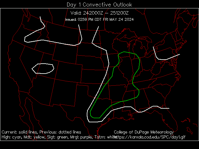
Storm Prediction Center's Slight Risk area for Thursday

We are carefully watching for the possibility of some strong to severe storms over southern Minnesota during the late afternoon and evening Thursday. Currently the Storm Prediction Center has a Slight Risk of Severe Storms over much of southern Minnesota for Thursday as a cold front and low pressure area approaches the area.

Some concerns over the formation of these storms though. It looks as though over a good portion of the Slight area, stretching down to Oklahoma, will be capped, which would limit formation of storms until the cap is broken (think of a shaken up bottle of pop. The energy can't be released until you unscrew (remove) the cap).

Also, at least up in our neck of the woods, we have a dry atmosphere, which will only help set off any storms that we do get.


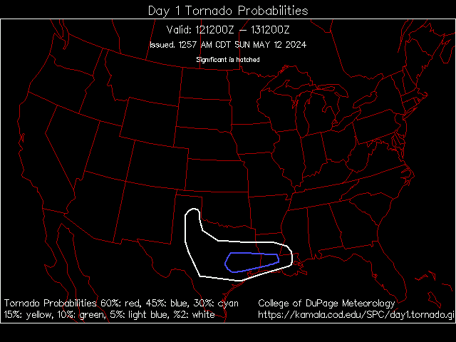
Percent probability of severe weather within 25 miles of a point -- Hatched (blue dashed area) is probability of significant severe weather within 25 miles of a point

The main threat that should occur with these storms in our area is large hail and some damaging winds. I won't rule out an isolated tornado or two, mainly in southern Minnesota (south of the cities), but the main tornado action (along with the main severe weather event) should be from Iowa down toward Kansas in the afternoon and evening.

I do not think that this will be a big outbreak in our area - more an isolated event. We could see a bigger outbreak, including tornadoes, as the system pushes eastward into Wisconsin, Iowa, Illinois, and south through Louisiana and Mississippi on Friday.

Tuesday, April 27, 2010

Nice for another day (but with a fire danger) then severe threat?

First, if you are planning on venturing out and about this evening, temps will be dropping through the 50s, eventually bottoming about around 37 for a low tonight with mainly clear skies.

We will continue to see very nice weather tomorrow, with temps higher than the 62 they were today... topping out around 66 with sunny skies. We could see some gustier winds out of the south though, to near 20 mph.

That, along with a low humidity reading, has caused the National Weather Service to put out a Fire Weather Watch for Douglas, Todd, and Morrison Counties from Noon Wednesday through 8 pm.

After tomorrow... well, it looks rainy. A chance of showers and thunderstorms is in the forecast every day and night from late Wednesday Night through the weekend (mainly showers though for the weekend, tapering off Saturday Night into Sunday).


The day that holds the most concern right now is Thursday. Right now a Slight Risk of Severe Storms is out for a sliver of the state, as you can see in the graphic, but I am cautious and would say that the southern half of the state should be on the lookout from the late afternoon through the evening. I would say the best threat would be large hail and some damaging winds. The Storm Prediction Center was not very clear AT ALL in their forecast this morning about the threat in Minnesota, but I think the main tornado threat will be more in southern Iowa through Kansas, Oklahoma and into Texas.

Highs will be around 70 Thursday, and in the lower 60s Friday through the weekend and into next week. More rain and possibly active weather as we get into the first half of next week.

Latest on The Yazoo City, MS, Tornado

Here is the latest information on the Yazoo City, MS, Tornado
Strength: EF4 with winds of 170 mph
Path Length: 149 miles
Maximum Width: 1.75 miles
Casualties: 10
What follows is the latest statement from the Jackson, MS, NWS office on the tornado.
PUBLIC INFORMATION STATEMENT
NATIONAL WEATHER SERVICE JACKSON MS
620 PM CDT MON APR 26 2010
..UPDATED INFORMATION ON LONG TRACK TORNADO PATH
NWS STORM SURVEY TEAMS FROM JACKSON AND MEMPHIS HAVE NOW
COMPLETED PRELIMINARY GROUND SURVEYS ALONG THE ENTIRE PATH
OF THE PRIMARY SUPERCELL THUNDERSTORM THAT TRACKED FROM
WEST OF TALLULAH, LOUISIANA...TO YAZOO CITY...TO NORTHEAST
OF WEST POINT...ON SATURDAY APRIL 26.
THE PRELMINARY CONCLUSION BASED ON THE GROUND SURVEYS IS
THAT A SINGLE...CONTINUOUS PATH OF TORNADIC DAMAGE WAS
PRODUCED FROM WEST OF TALLULAH TO THE EXTREME WESTERN PART
OF OKTIBBEHA COUNTY IN NORTHEAST MISSISSIPPI. THE TORNADO
APPEARED TO DISSIPATE AT THIS POINT...BUT THE STORM PRODUCED
TWO ADDITIONAL TORNADOES IN THE NWS JACKSON SERVICE AREA...
AN EF-1 IN NORTHERN OKTIBBEHA COUNTY...AND AN EF-2 IN
NORTHEAST CLAY COUNTY. INFORMATION REGARDING THESE TORNADOES
HAS BEEN PROVIDED IN EARLIER STATEMENTS.
THE MAIN LONG TRACK TORNADO WAS STRONG ALMOST FROM ITS INITIAL
STAGE OF DEVELOPMENT IN NORTHEAST LOUISIANA. EF-2 AND
EF-3 DAMAGE WAS COMMON ALL ALONG THE TORNADO'S PATH INTO
CENTRAL MISSISSIPPI...WITH TWO AREAS OF EF-4 DAMAGE IN YAZOO
AND HOLMES COUNTIES. AFTER CROSSING INTERSTATE 55...THE TORNADO
WEAKENED...WITH EF-1 AND OCCASIONAL EF-2 DAMAGE BEING COMMON
AS THE TORNADO MOVED ACROSS ATTALA COUNTY. THE TORNADO REINTENSIFIED
AS IT MOVED INTO CHOCTAW COUNTY...WITH AT LEAST HIGH END EF-3 DAMAGE
OCCURRING NORTHWEST OF THE WEIR COMMUNITY. THE TORNADO REMAINED
STRONG BEFORE RAPIDLY WEAKENING AND THEN DISSIPATING JUST AFTER
MOVING INTO OKTIBBEHA COUNTY.
HERE IS A PRELIMINARY SUMMARY OF THIS TORNADO:
BEGINNING POINT: 5 MILES W OF TALLULAH, LA 32.408N, 91.283W
AT 11:06 AM
ENDING POINT: 5.5 MILES N OF STURGIS, MS 33.430N, 89.054W
AT 1:52 PM
PATH LENGTH: 149 MILES
MAXIMUM WIDTH: 1.75 MILES
RATING: EF-4, WITH MAXIMUM WINDS OF 170 MPH
CASUALTIES: 10 TOTAL FATALITIES WITH DOZENS OF INJURIES
IT MUST BE STRESSED THAT ALL OF THIS INFORMATION IS PRELIMINARY
AND SUBJECT TO LATER ADJUSTMENT. A TORNADO OF THIS STRENGTH AND
MAGNITUDE REQUIRES A TREMENDOUS AMOUNT OF DAMAGE SURVEYS AND DATA
ANALYSIS. AN ANALYSIS OF AERIAL SURVEY INFORMATION COULD STILL
RESULT IN THE TORNADO BEING BROKEN UP INTO MORE THAN ONE PATH.
THE NWS WILL CONTINUE TO PROVIDE UPDATES AS ADDITIONAL
INFORMATION IS OBTAINED...AND IS PLANNING TO HOLD A MEDIA BRIEFING
LATER THIS WEEK TO PROVIDE A FULL ANALYSIS OF THE STORM AND THE
DAMAGE SURVEY RESULTS. ALSO...A WEBPAGE CONCERNING THIS WEATHER
EVENT...INCLUDING DAMAGE PICTURES AND MAPS...WILL BE UPDATED AT
WWW.SRH.NOAA.GOV/JAN.
THE NWS WOULD LIKE TO THANK ALL OF OUR PARTNERS IN LAW ENFORCEMENT
AND EMERGENCY MANAGEMENT FOR THEIR INVALUABLE ASSISTANCE IN
PERFORMING OUR DAMAGE SURVEYS.

Saturday, April 24, 2010

SWAW Day 5 Heat

Note: Meant to post this yesterday! Sorry!

Once again, it's Severe Weather Awareness Week here in Minnesota and Wisconsin, brought to you by the National Weather Service along with the Divisions of Homeland Security and Emergency Management. Each day a new topic of severe weather will once again be covered:

Monday: Thunderstorms, Hail, Wind and Lightning
Tuesday: Severe Weather Watches and Warnings, and How to Receive Severe Weather Information
Wednesday: Flash Floods
Thursday: Tornadoes (Including Two Tornado Drills)
Friday: Heat Waves

We will bring you this information every day from the National Weather Service, including a special post on Wednesday outlining procedures for Thursdays Tornado Drills. Today's subject is Heat Waves. We hope you find this information informative and helpful as we enter severe weather season and remember to stick with this blog for the very latest on severe weather throughout the season.

Heat wave brochure [PDF] - Courtesy of the National Weather Service - Chanhassen
Official Heat index chart [PDF] - Courtesy of the National Weather Service - Chanhassen Office
Heat Symptoms [PDF] - Courtesy of the Minnesota Department of Health
Keep Cool [PDF] - Courtesy of the Minnesota Department of Health
Hot Weather Kills [PDF] - Courtesy of the Minnesota Department of Health

More information from the National Weather Service

Minnesota's Deadliest Weather Factor Since 1990...
The second greatest number of weather fatalities in Minnesota since 1990 has been due to excessive heat. Fourteen people have died from high heat and humidity. Only flooding has killed more people in the last 18 years.

Wisconsin's Deadliest Weather Factor Since 1982...
The greatest number of weather fatalities in Wisconsin since 1982 has been due to excessive heat. 116 people have died from high heat and humidity. This total is more than tornadoes, flooding, blizzards or anything else. The 1995 summer heat waves hold the record as the number one weather-related killer in Wisconsin since it became a state in 1848. Most deaths occurred in the major urban areas in southeast Wisconsin, but there have been a number of fatalities in the rest of the state as well.
Fortunately, there were no deaths last year from excessive heat in either WIsconsin or Minnesota.
In the last 10 years, a national average of 219 people have died as a result of health problems directly related to excessive heat. Considering this death toll, the National Weather Service has stepped up its efforts to more effectively alert the general public to the hazards of heat waves.
Based on research findings, the National Weather Service devised the Heat Index (HI). It is an accurate measure of how hot it really feels when the relative humidity is added to the actual air temperature. It is important to note that since heat index values were devised for shady, light wind conditions, exposure to full sun can increase values by up to 15 degrees.
Heat disorders generally have to do with a reduction or collapse in the ability of the body to shed heat by circulatory changes and sweating. In other words, a chemical imbalance caused by too much sweating. When heat gain exceeds the level the body can remove, or when the body cannot compensate for fluids and salt lost through perspiration, the inner-core temperature of the body begins to rise and heat-related illnesses may develop. Ranging in severity, heat disorders share one common feature: the individual has over-exposed or over-excerised for his/her age and physical condition in the existing thermal environment.
Sunburn, with its ultraviolet radiation burns, can also significantly retard the ability of skin to shed excess heat.

Safety tips...
The National Weather Service will issue advisories or warnings when the heat index is expected to have a significant impact on public safety. The common guidelines for the issuance of excessive heat warnings is when the maximum daytime index is expected to reach 110 or 115, and the nighttime low temperature does not fall below 75 or 80 degrees.
Here are some tips to follow to ensure that heat-related problems do not impact you...
  • Slow down. Strenuous activities should be reduced, eliminated or rescheduled to the coolest time of the day. Individuals at risk should stay in the coolest available place, not necessarily indoors. Dress for summer. Lightweight, light-colored clothing reflects heat and sunlight and helps your body maintain normal temperatures.
  • Put less fuel on your inner fires. Foods such as proteins that increase metabolic heat production also increase water loss.
  • Drink plenty of water or other non-alcoholic fluids. Your body needs water to keep cool. Drink plenty of fluids, even if you don't feel thirsty. However, those who suffer from epilepsy, heart, kidney or liver disease, are on fluid restrictive diets, or have a problem with fluid retention should consult a physician before increasing their consumption of fluids.
  • Do not drink alcoholic beverages.
  • Spend more time in air-conditioned places. Air conditioning in homes and other buildings markedly reduces danger from the heat. If you cannot afford an air conditioner, spending time each day in an air-conditioned environment during hot weather affords some protection.
  • Be careful not to get too much sun. Sunburn makes the job of heat dissipation that much more difficult.

Thursday, April 22, 2010

SWAW Day 4 Tornado Safety

Once again, it's Severe Weather Awareness Week here in Minnesota and Wisconsin, brought to you by the National Weather Service along with the Divisions of Homeland Security and Emergency Management. Each day a new topic of severe weather will once again be covered:

Monday: Thunderstorms, Hail, Wind and Lightning
Tuesday: Severe Weather Watches and Warnings, and How to Receive Severe Weather Information
Wednesday: Flash Floods
Thursday: Tornadoes (Including Two Tornado Drills)
Friday: Heat Waves

We will bring you this information every day from the National Weather Service. Today's subject is Tornadoes. To go along with today's information, the National Weather Service will run two tornado drills in the area: one at 1:45 and the other at 6:55. It is asked that you at least figure out during these times what you would do in the event of an actual tornado warning. For more information on today's timeline of events, check out yesterday's post.

We hope you find this information informative and helpful as we enter severe weather season and remember to stick with this blog for the very latest on severe weather throughout the season.

From Stearns County "According to National Weather Service data, tornadoes have occurred in every Minnesota county at some time during the past 60 years. Stearns County has experienced 40 tornadoes since 1950." Click here for more from Stearns County Emergency Services

More tornado information from the NWS

Before the Tornado...
Tornado watches highlight the area where tornadoes are most likely to develop. Continue with your normal activites, but keep informed of the latest weather information and be ready to get to shelter in case tornadoes develop quickly.

In the Home...
Go to the basement if possible. Get under a table, work bench, or some other sturdy furniture to avoid falling debris. A stairwell is also a good place to hide during a tornado.

If You Cannot Get to a Basement...
Go to a small interior room on the lowest floor. Closets, bathrooms, and interior halls afford the best protection in most cases, or try to hide under a bed. Get under something sturdy or cover yourself with blankets. Stay away from windows.

In an Apartment, School or Office Building...
Move to the inner-most room on the lowest level or to a pre-designated shelter area. Stay away from windows. If in a hallway, crouch down and protect your head from flying debris. Avoid areas with glass and large roof expansions.

In a Mobile Home, Car, Truck or Other Vehicle...
Abandon these as quickly as possible. Seek a sturdy shelter or permanent structure. Remember that many deaths occur when people try to drive away in a vehicle, but get caught in the deadly winds. Avoid bridges since they act as wind tunnels.
Last year, Minnesota saw 24 tornadoes, fewer than the average since the early 90s. The strongest were two tornadoes rated EF-2, one that hit Austin on June 17, and another that hit Swift Falls on July 14. There were no deaths or injuries across the state.
Wisconsin had 16 tornadoes last year, and all were weak. Only five reached the EF-1 category, and the others were all EF-0. There were no deaths or injuries in Wisconsin last year due to tornadoes. St. Croix County had the most tornadoes in the state in 2009, with five.

SWAW Side Note: Siren Activation and Thursday's Tornado Drills

Once again, it's Severe Weather Awareness Week here in Minnesota and Wisconsin, brought to you by the National Weather Service along with the Divisions of Homeland Security and Emergency Management. Each day a new topic of severe weather is covered, but we thought that we would bring you additional information on siren activation and tomorrow's tornado drills. We hope you find this information informative and helpful as we enter severe weather season and remember to stick with this blog for the very latest on severe weather throughout the season.


Siren Activation Information


Counties and cities own the sirens, and therefore decide how and when to activate them. The National Weather Service does not sound them.
There are many different policies regarding siren activation that are used by the various cities and counties. Some will activate sirens across the entire county for tornado warnings only.  Others will activate sirens countywide for tornado warnings and all severe thunderstorm warnings. Some will activate sirens across the entire county for tornado warnings and severe thunderstorms that have winds of at least 70 or 75 mph. Others will activate sirens only for portions of counties.  Local officials may also sound the sirens anytime they believe severe weather is a threat, even if there is no warning from the National Weather Service.
Sirens normally sound for about three minutes, and then go silent.  It is very rare to keep the sirens sounding for the entire warning, since that would cause the backup battery to run out, which would be critical in the event that power goes out.  Furthermore, the siren motor will fail much more quickly if the siren sounds continuously.  Some jurisdictions may repeat siren activation every few minutes.
There is no such thing as an "all-clear" for storms.
Please check with your local public safety officials for details on when warning sirens are sounded in your community.


Tornado Watch/Warning Drills
 

The National Weather Service, Wisconsin Emergency Management, the Minnesota Division of Homeland Security and Emergency Management, and other state, county and local agencies have come together to host Severe Weather Awareness Week activities. On Thursday, April 22nd, simulated tornado watches and warnings will be issued to test the statewide warning and communications systems. The schedule for April 22nd is as follows (all times CDT):

1:00 PM:  The National Weather Service will issue a simulated tornado watch for Minnesota and Wisconsin.

1:40 PM:  The National Weather Service will issue a simulated tornado warning for 9 counties of western Wisconsin (Barron, Chippewa, Dunn, Eau Claire, Pepin, Pierce, Polk, Rusk and St Croix). Note that most cities and counties will activate outdoor warning siren systems.

1:45 PM:  The National Weather Service will issue a simulated tornado warning for Minnesota counties (except those in the northwestern part of the state). Note that most cities and counties will activate outdoor warning siren systems.

2:00 PM: The National Weather Service will issue an "End of Test" message using the Severe Weather Statement product. It should be stated that outdoor warning sirens will not be sounded again for this all clear, nor will there be any warning tone on NOAA Weather Radio.

6:55 PM:  Another simulated tornado warning will be issued for 73 participating counties in Minnesota. Those counties not participating are: Aitkin, Carlton, Hubbard, Itasca, Kanabec, Kittson, Lincoln, Otter Tail, Pennington, Pipestone, Sibley, St. Louis, Watonwan and Wilkin. A graphic of the counties participating in the evening drill is available at http://www.severeweather.state.mn.us/Documents/Participating_Counties_Drill_Map_2010.pdf
The 6:55 PM warning will be issued by the six National Weather Service offices that serve Minnesota. It will be issued as a test of family preparedness in the home and for second shift workers.

Wednesday, April 21, 2010

SWAW Day 3 Flash Floods

Once again, it's Severe Weather Awareness Week here in Minnesota and Wisconsin, brought to you by the National Weather Service along with the Divisions of Homeland Security and Emergency Management. Each day a new topic of severe weather will once again be covered:

Monday: Thunderstorms, Hail, Wind and Lightning
Tuesday: Severe Weather Watches and Warnings, and How to Receive Severe Weather Information
Wednesday: Flash Floods
Thursday: Tornadoes (Including Two Tornado Drills)
Friday: Heat Waves

We will bring you this information every day from the National Weather Service, including a special post later today outlining procedures for Thursdays Tornado Drills. Today's subject is Flash Floods. We hope you find this information informative and helpful as we enter severe weather season and remember to stick with this blog for the very latest on severe weather throughout the season.

More on Flood Safety from the NWS

On a National Level...
Floods claim nearly 200 lives annually, force 300,000 persons from their homes, and result in property damage in excess of 2 billion dollars. Characteristically, 75 percent of flash flood deaths occur at night with half of the victims dying in their automobiles or other vehicles. It may be difficult to believe, but many deaths occur when persons knowingly drive around road barricades indicating the road is washed out ahead.
There were no flood-related fatalities or injuries in Minnesota or Wisconsin in 2009.

In 2008...
Wisconsin had one flood-related fatality in 2008, late on June 12th near Wales, when a man drove into a flooded area. Minnesota also had one flood-related fatality in 2008.  This occurred on June 12th near Oakland when a man drove into a flooded area

In 2007...
Disastrous flooding struck southeast Minnesota and southwest Wisconsin on August 18th and 19th. Eight people died that weekeend...  7 in Minnesota and 1 in Wisconsin. Most deaths occurred in vehicles. A statewide record for 24-hour rainfall was set in Minnesota when 15.1 inches fell 1 mile south of Hokah.

Are You Prepared?
Assume a thunderstorm produces 6 inches of rain in less than 6 hours time near your community. Storms of this magnitude or greater occur several times each year in the U.S.  Would you know what action to take to protect yourself and the people who depend on you for safety? After a major flood event, one of the most common quotes from the survivors of the flood is the expression they did not believe it could happen to them or in their community.

Before the Flooding...
There is nothing anyone can do to prevent the occurrence of flash flood producing rainfall. However, by striving for sound flood plain zoning, developing an emergency action plan in advance of the disaster, purchasing flood insurance at least 30 days before the flooding, and being aware of the dangers associated with extremely heavy rainfall and flooding, there is a chance of decreasing the death toll and property damage that results from flash flooding.

Tuesday, April 20, 2010

SWAW Day 2 Severe Weather Watches and Warnings and How to Receive Severe Weather Information

Once again, it's Severe Weather Awareness Week here in Minnesota and Wisconsin, brought to you by the National Weather Service along with the Divisions of Homeland Security and Emergency Management. Each day a new topic of severe weather will once again be covered:

Monday: Thunderstorms, Hail, Wind and Lightning
Tuesday: Severe Weather Watches and Warnings, and How to Receive Severe Weather Information
Wednesday: Flash Floods
Thursday: Tornadoes (Including Two Tornado Drills)
Friday: Heat Waves

We will bring you this information every day from the National Weather Service, including a special post on Wednesday outlining procedures for Thursdays Tornado Drills. Today's subject is Severe Weather Watches and Warnings, and How to Receive Severe Weather Information. We hope you find this information informative and helpful as we enter severe weather season and remember to stick with this blog for the very latest on severe weather throughout the season.

More information on dissemination services from the NWS

Watches...
Are issued when conditions are favorable for tornadoes, severe thunderstorms or flash floods. If you are in a watch area, continue with normal activities but also make plans to seek shelter if necessary.

Warnings...
Are issued when severe weather has been reported or is imminent. Seek shelter immediately if you are in or near the path of the storm. Warnings are issued by county and city names. Make sure you know the name of the county in which you live and the cities that surround you.

Advance Information...
The forecast and warning process begins one or more days ahead of time, when the threat area is determined. Hazardous weather outlooks are issued early every morning, and updated as conditions warrant.

If a Watch is Issued...
Local weather offices are staffed with extra personnel. State officials are notified and they pass the information to the county and local level. Counties and cities activate their spotter groups as the threat increases. TV and radio stations pass the word to the public.

If a Warning is Issued...
Warnings are disseminated swiftly in a multitude of ways, including TV, radio, and over the internet. Advances in technology have allowed people to receive warnings via cell phone, pager, and numerous other methods. Spotters provide important reports on the storm, and emergency officials carry out the plans that the emergency managers have developed. Updates are issued frequently until the immediate threat has ended.

Sirens...
Counties and cities own the sirens and therefore decide how and when to activate them.  The National Weather Service does not sound them. There are many different policies by counties and cities. Some will activate them across the entire county for a tornado warning only. Others will activate sirens countywide for tornado warnings and all severe thunderstorm warnings. Some will activate sirens across the entire county for tornado warnings and severe thunderstorms that have winds of at least 70 or 75 mph.  Others will activate sirens only for portions of counties. Also, local officials may sound the sirens anytime they believe severe weather is a threat, even if there is no warning from the National Weather Service.
Sirens normally sound about 3 minutes and then go silent. It is very rare to keep the sirens sounding for the entire warning, since that will cause the backup battery to run out, which would be critical in the event power goes out. Furthermore, the siren motor will fail much more quickly if the siren sounds continuously. Some jurisdictions may repeat siren activation every few minutes.  There is no such thing as an "All Clear" for storms.

Media...
Media outlets receive the warning information and disseminate it to you, often by interrupting programming. Many television stations use a crawl and other visual means.

NOAA Weather Radio...
The tone alert feature of NOAA Weather Radio will activate specially built receivers, sounding an alarm to alert you to the danger.  It sounds its alert anytime the National Weather Service issues a warning, even in the middle of the night. Make sure you have a NOAA Weather Radio, as you can not always depend on sirens, phone calls or seeing the warnings on television.

Monday, April 19, 2010

SWAW Day 1 Thunderstorms, Hail, Wind and Lightning

Once again, it's Severe Weather Awareness Week here in Minnesota and Wisconsin, brought to you by the National Weather Service along with the Divisions of Homeland Security and Emergency Management. Each day a new topic of severe weather will once again be covered:

Monday: Thunderstorms, Hail, Wind and Lightning
Tuesday: Severe Weather Watches and Warnings, and How to Receive Severe Weather Information
Wednesday: Flash Floods
Thursday: Tornadoes (Including Two Tornado Drills)
Friday: Heat Waves

We will bring you this information every day from the National Weather Service, including a special post on Wednesday outlining procedures for Thursdays Tornado Drills. Today's subject is Thunderstorms, Hail, Wind and Lightning. We hope you find this information informative and helpful as we enter severe weather season and remember to stick with this blog for the very latest on severe weather throughout the season.

Brochure from NWS with additional information

Thunderstorms...
Affect relatively small areas when compared with most other storms. The typical thunderstorm is 15 miles in diameter and lasts for 30 minutes. Despite this size, all thunderstorms are dangerous. Severe thunderstorms produce large hail or winds of at least 58 mph. Some wind gusts can exceed 100 mph and produce tornado-like damage. Many communities will sound their outdoor sirens for very damaging straight-line winds. When a severe thunderstorm threatens, stay inside a strong structure. Mobile home occupants should go to a more permanent structure.

Hail...
Is another product of thunderstorms that annually causes nearly one billion dollars in damage throughout the United States. Many of the losses are incurred by farmers. The most common diameter is pea size, but hail can be as large as golf balls and baseballs. In extreme cases, hail can reach grapefruit size. Large hail stones fall at speeds faster than 100 mph and have been known to kill people.
The largest hail stone in Minnesota last year was 3.25 inches on June 17 near Blooming Prairie.
Wisconsin's largest hailstone in 2010 was baseball size (2.75 inches), falling on June 18 across Dane County, and on July 24 in Lafayette County.

Thunderstorm Winds...
Thunderstorms can produce strong wind gusts. These straight-line winds have been known to exceed 100 mph. For this reason, you should treat severe thunderstorms just as you would tornadoes. Move to an appropriate shelter if you're in the path of the storm.
The strong outrush of wind from a thunderstorm is often called a downburst. One of the primary causes is rain-cooled air, which accelerates rapidly downward, producing a potentially damaging gust of wind.
Strong downbursts are often mistaken for tornadoes. They can produce extensive damage and are often accompanied by a roaring sound similar to that of a tornado. Downbursts can easily overturn mobile homes, tear roofs off of houses, and topple trees. People who are camping are especially vulnerable, due to trees toppling on their camp sites.
The highest thunderstorm wind gust last year in Wisconsin was 95 mph, near Garfield on August 28.
The highest thunderstorm wind gust in Minnesota last year was 100 mph, occurring on July 14th near Spicer.

Lightning...
Every thunderstorm produces lightning, which on a national basis kills more people than tornadoes in a given year.
Lightning kills around 100 Americans annually, with about 300 injuries. In Wisconsin and Minnesota, there have been many deaths and injuries over the years, most in areas such as camp grounds, although people have been injured indoors when talking on the phone.
The following are some lightning safety tips...
  1. All thunderstorms produce lightning. It is surprising that so many people are not aware of this.
  2. Get inside a building or enclosed vehicle. Many fatalities occur when the warning signs are ignored.
  3. If caught in an open area with lightning all around, crouch down immediately! Put your hands on your knees but do not lie down on the ground.
  4. Do not use a telephone or electrical appliance. A nearby lightning strike can travel through the phone or power lines right into the home.
  5. Avoid seeking shelter beneath lone trees.
Myths and facts about lightning...
Myth: If it's not raining, there is no danger from lightning.
Fact: Lightning often strikes away from heavy rainfall, and may occur as far as 10 miles away from any rainfall.

Myth: Rubber soles of shoes or rubber tires on a car will protect you from being injured by lightning.
Fact: Rubber provides no protection from lightning. However, the steel frame of a hard-topped vehicle provides increased protection from lightning (if you are not touching metal in the car).

Myth: People struck by lightning carry an electrical charge and should not be touched.
Fact: Lightning-strike victims carry no electrical charge and should be attended to immediately.

Myth: Heat lightning occurs after very hot summer days and poses no threat.
Fact: What is referred to as "heat lightning" is actually lightning from a thunderstorm too far away for thunder to be heard. However, the storm may be moving in your direction.

Monday, April 5, 2010

Tornado Potential Over Southern Iowa, Northern Missouri

We are watching a potentially dangerous situation for later today over southern Iowa and northern Missouri later today. The Stprm Prediction Center has that area in a 10% hatched tornado threat, meaning that storms later today have the potential of producing strong, large tornadoes along with very large hail and damaging winds, and with the latest update had seriously considered upgrading the area to a Moderate Risk of severe storms. It looks like it would be a perfect day for VORTEX 2 if they were already going for the year.

Follow me on Twitter @weathrlver