 Ha, who could have saw this one coming? The severe threat for today has moved south and east of the Twin Cities, so I don't expect much severe weather to occur at all in Minnesota later today according to the current maps, and there isn't a chance for severe weather the rest of the weekend. We will still see scattered showers and storms today around the area (temps around 60, but falling), that will become more numerous overnight. Showers continue into the morning Saturday, but will taper off and the afternoon, while it will be cooler (around 50), at least won't be rainy. More rain and thunderstorms will move back into the picture Saturday Night and last into Sunday, but will be even cooler (around 45). Get yourselves ready for a wet weekend!
Friday, April 24, 2009
Severe Weather Threat Diminishes and Your Weekend Forecast
Ha, who could have saw this one coming? The severe threat for today has moved south and east of the Twin Cities, so I don't expect much severe weather to occur at all in Minnesota later today according to the current maps, and there isn't a chance for severe weather the rest of the weekend. We will still see scattered showers and storms today around the area (temps around 60, but falling), that will become more numerous overnight. Showers continue into the morning Saturday, but will taper off and the afternoon, while it will be cooler (around 50), at least won't be rainy. More rain and thunderstorms will move back into the picture Saturday Night and last into Sunday, but will be even cooler (around 45). Get yourselves ready for a wet weekend!
SWAW, Day 5: Heat Waves
It's Severe Weather Awareness Week in MN and WI, which means its time to start going over what everything is again and what precautions to take when severe weather strikes. While no major heat is in the forecast, some severe weather might be, so now is as good as time as any to relearn what we do in summertime, like how we have to relearn the winter warnings (and how to drive) in the winter. Remember, throughout the summer we'll cover it the best we can on Facebook, Twitter, and now Blogger. Today's topic, brought to you by the National Weather Service, is Heat Waves -- I've also included what watches, warnings, and advisories there are for heat.
Heat Waves (can also find more from this NWS Publication on Heat Waves)
Watches...
Excessive Heat Watch: In Hennepin and Ramsey counties: Maximum heat index at Minneapolis/St. Paul International Airport is expected to reach 105 or greater for 1 day, or the maximum heat index is expected to reach 100 or greater and an overnight low temperature no cooler than 75 for 2 days in a row. In addition, the Heat Watch/Warning System must recommend a watch.
Excessive Heat Watch: Outside Hennepin and Ramsey counties: Maximum heat index reaches 105 or greater and a minimum heat index of 75 or greater for at least 48 hours.
Warnings...
Excessive Heat Warning: In Hennepin and Ramsey counties: Maximum heat index at Minneapolis/St. Paul International Airport reaches 105 or greater for 1 day, or the maximum heat index reaches 100 or greater and the overnight low temperature is no cooler than 75 for 2 days in a row. In addition, the Heat Watch/Warning System must recommend a warning. A warning may also be issued if advisory criteria are expected for 4 days in a row.
Excessive Heat Warning: Outside Hennepin and Ramsey counties: Maximum heat index reaches 105 or greater and a minimum heat index of 75 or greater for at least 48 hours. A warning may also be issued if advisory criteria are expected for 4 days in a row.
Advisories...
Heat Advisory: In Hennepin and Ramsey counties: Maximum heat index at Minneapolis/St. Paul International Airport is expected to reach 105 or greater for 1 day, or the maximum heat index is expected to reach 100 or greater and an overnight low temperature no cooler than 75 for 2 days in a row.
Heat Advisory: Outside Hennepin and Ramsey counties: Maximum heat index reaches 100 and/or the maximum temperature reaches 95 or higher.
Minnesota's Deadliest Weather Factor Since 1990...
The second greatest number of weather fatalities in Minnesota since 1990 has been due to excessive heat. Fourteen people have died from high heat and humidity. Only flooding has killed more people in the last 18 years.
Wisconsin's Deadliest Weather Factor Since 1982...
The greatest number of weather fatalities in Wisconsin since 1982 has been due to excessive heat. 116 people have died from high heat and humidity. This total is more than tornadoes, flooding, blizzards or anything else. The 1995 summer heat waves hold the record as the number one weather-related killer in Wisconsin since it became a state in 1848. Most deaths occurred in the major urban areas in southeast Wisconsin, but there have been a number of fatalities in the rest of the state as well.
Fortunately, there were no deaths last year from excessive heat in either WIsconsin or Minnesota.
In the last 10 years, a national average of 219 people have died as a result of health problems directly related to excessive heat. Considering this death toll, the National Weather Service has stepped up its efforts to more effectively alert the general public to the hazards of heat waves.
Based on research findings, the National Weather Service devised the Heat Index (HI). It is an accurate measure of how hot it really feels when the relative humidity is added to the actual air temperature. It is important to note that since heat index values were devised for shady, light wind conditions, exposure to full sun can increase values by up to 15 degrees.
Heat disorders generally have to do with a reduction or collapse in the ability of the body to shed heat by circulatory changes and sweating. In other words, a chemical imbalance caused by too much sweating. When heat gain exceeds the level the body can remove, or when the body cannot compensate for fluids and salt lost through perspiration, the inner-core temperature of the body begins to rise and heat-related illnesses may develop. Ranging in severity, heat disorders share one common feature: the individual has over-exposed or over-excerised for his/her age and physical condition in the existing thermal environment.
Sunburn, with its ultraviolet radiation burns, can also significantly retard the ability of skin to shed excess heat.
Safety tips...
The National Weather Service will issue advisories or warnings when the heat index is expected to have a significant impact on public safety. The common guidelines for the issuance of excessive heat warnings is when the maximum daytime index is expected to reach 110 or 115, and the nighttime low temperature does not fall below 75 or 80 degrees.
Here are some tips to follow to ensure that heat-related problems do not impact you...
- Slow down. Strenuous activities should be reduced, eliminated or rescheduled to the coolest time of the day. Individuals at risk should stay in the coolest available place, not necessarily indoors. Dress for summer. Lightweight, light-colored clothing reflects heat and sunlight and helps your body maintain normal temperatures.
- Put less fuel on your inner fires. Foods such as proteins that increase metabolic heat production also increase water loss.
- Drink plenty of water or other non-alcoholic fluids. Your body needs water to keep cool. Drink plenty of fluids, even if you don't feel thirsty. However, those who suffer from epilepsy, heart, kidney or liver disease, are on fluid restrictive diets, or have a problem with fluid retention should consult a physician before increasing their consumption of fluids.
- Do not drink alcoholic beverages.
- Spend more time in air-conditioned places. Air conditioning in homes and other buildings markedly reduces danger from the heat. If you cannot afford an air conditioner, spending time each day in an air-conditioned environment during hot weather affords some protection.
- Be careful not to get too much sun. Sunburn makes the job of heat dissipation that much more difficult.
Thursday, April 23, 2009
A Look at the Severe Chance Friday
 This is the latest outlook for Friday from the Storm Prediction Center, and its a probabilistic outlook, showing where the higher chances of severe storms are. As a quick overview for those of you who don't know what everything means on this map, the numbers represent the probability of severe weather within 20 miles of any given location. Within the blue slanted "hatched area" there is at least a 10% risk of "significant severe weather" within 25 miles of any point. Typically in these blue marked territories we look for the worse weather of the day, whether it be large hail, damaging winds, or tornadoes. From looking at everything, I agree with this "hatched area". The greatest risk of severe weather will be in the Iowa and Nebraska areas, and might contain very large hail, damaging winds, and a few tornadoes. Cities in this area would include Sioux Falls and Sioux City. Parts of Wisconsin also have a higher chance of severe weather, but that will mainly be in the large hail and damaging wind categories. So according to the graphics I have looked at, the greatest threat of severe weather will be definitely south and east of the STC area. The closer you get to Iowa or Wisconsin tomorrow, though, the more the odds go up of seeing severe storms. Cities such as Fairmont, Mankato, Worthington, and Albert Lea, and even the Twin Cites will need to be on the lookout tomorrow. As you can see, this area is also really close to the STC area. More than likely the cold front will have pushed southward enough to keep us out of the severe area, but even so people in the STC area should keep a look out for the possibility of severe weather since the boundaries are still so close to the area. Watches and warnings are likely tomorrow, especially in NE/IA/WI... I'll be updating if any of these decides to strike close to home. Also, expect an update by 2 PM tomorrow on the latest on the severe weather threat for the area.
SWAW, Day 4: Tornado Safety Information
It's Severe Weather Awareness Week in MN and WI, which means its time to start going over what everything is again and what precautions to take when severe weather strikes. The Storm Prediction Center has a Slight Risk of Severe Storms Friday just south and east of the STC area, so now is as good as time as any to relearn what we do in summertime, like how we have to relearn the winter warnings (and how to drive) in the winter. Remember, throughout the summer we'll cover it the best we can on Facebook, Twitter, and now Blogger. Today's topic, brought to you by the National Weather Service, is Tornado Safety -- I've also included what a watch and warning is, along with the procedure for today's drills, siren information, and a few other local facts thanks to Paul Douglas.
Tornado Safety Information

Atmospheric conditions are favorable for the development of severe thunderstorms capable of producing tornadoes.

A severe thunderstorm has developed and has either produced a tornado or radar has indicated intense low level rotation in the presence of atmospheric conditions conducive to tornado development.
Tornado Watch/Warning Drills
Tornado Safety Information
Atmospheric conditions are favorable for the development of severe thunderstorms capable of producing tornadoes.
A severe thunderstorm has developed and has either produced a tornado or radar has indicated intense low level rotation in the presence of atmospheric conditions conducive to tornado development.
Before the Tornado... Tornado watches highlight the area where tornadoes are most likely to develop. Continue with your normal activities, but keep informed of the latest weather information and be ready to get to shelter in case tornadoes develop quickly.
In the Home... Go to the basement if possible. Get under a table, work bench, or some other sturdy furniture to avoid falling debris. A stairwell is also a good place to hide during a tornado.
If You Cannot Get to a Basement... Go to a small interior room on the lowest floor. Closets, bathrooms, and interior halls afford the best protection in most cases, or try to hide under a bed. Get under something sturdy or cover yourself with blankets. Stay away from windows.
In an Apartment, School or Office Building... Move to the inner-most room on the lowest level or to a pre-designated shelter area. Stay away from windows. If in a hallway, crouch down and protect your head from flying debris. Avoid areas with glass and large roof expansions.
In a Mobile Home, Car, Truck or Other Vehicle... Abandon these as quickly as possible. Seek a sturdy shelter or permanent structure. Remember that many deaths occur when people try to drive away in a vehicle, but get caught in the deadly winds. Avoid bridges since they act as wind tunnels.
Last year, Minnesota saw 43 tornadoes, a typical number since the early 90s. The strongest were three tornadoes rated EF-3, one in Hugo on May 25, another near Park Rapids on June 6, and one near Willmar on July 11. There was one fatality, as a 2 year old boy was killed in Hugo on May 25. There were also 24 injuries across the state. The closest tornado to the St. Cloud area was in Sherburne County.
The earliest verified tornado in Minnesota occurred on March 18, 1968, north of Truman, and the latest in any year on November 16, 1931, east of Maple Plain.
Historically and statistically, June is the month of greatest frequency with July not far behind. May has the third greatest frequency, followed closely by August. Nearly 3/4 of all tornadoes in Minnesota have occurred during the three months of May (16%), June (34%), and July (26%)
Wisconsin had 38 tornadoes last year, but only one reached the category of EF-3, and that was a bizarre tornado on January 7 near Powers Lake. There was one other tornado on January 7 near Kenosha. These were only the 2nd and 3rd tornadoes ever to strike Wisconsin in January. There were no tornado-related deaths in Wisconsin last year, but 21 people were injured.
Tornado Watch/Warning Drills
The National Weather Service, Wisconsin Emergency Management, the Minnesota Division of Homeland Security and Emergency Management, and other state, county and local agencies have come together to host Severe Weather Awareness Week activities. On Thursday, April 23rd, simulated tornado watches and warnings will be issued to test the statewide warning and communications systems. The schedule for April 23rd is as follows:
(all times CDT)
9:00 AM: The National Weather Service will issue a simulated tornado watch for Minnesota (except the northwest portion of the state).
1:00 PM: The National Weather Service will issue a simulated tornado watch for Wisconsin.
1:40 PM: The National Weather Service will issue a simulated tornado warning for 9 counties of western Wisconsin (Barron, Chippewa, Dunn, Eau Claire, Pepin, Pierce, Polk, Rusk and St Croix). Note that most cities and counties will activate outdoor warning siren systems.
1:45 PM: The National Weather Service will issue a simulated tornado warning for Minnesota counties (except those in the northwestern part of the state). Note that most cities and counties will activate outdoor warning siren systems.
2:00 PM: The National Weather Service will issue an "End of Test" message using the Severe Weather Statement product. It should be stated that outdoor warning sirens will not be sounded again for this all clear, nor will there be any warning tone on NOAA Weather Radio.
6:55 PM: Another simulated tornado warning will be issued for participating counties in Minnesota. Those counties are: Anoka, Benton, Big Stone, Brown, Carver, Cass, Chippewa, Chisago, Cottonwood, Crow Wing, Dakota, Douglas, Freeborn, Goodhue, Hennepin, Isanti, Jackson, Kandiyohi, Lac Qui Parle, Lake, Le Sueur, Lyon, Martin, McLeod, Meeker, Mille Lacs, Morrison, Mower, Murray, Nicollet, Nobles, Olmsted, Pine, Pipestone, Pope, Ramsey, Redwood, Renville, Rice, Rock, Scott, Sherburne, Stearns, Steele, Stevens, Swift, Todd, Traverse, Wabasha, Waseca, Washington, Watonwan, Winona and Wright.
A graphic of the counties participating in the evening drill is available at http://www.severeweather.state.mn.us/Documents/Participating_Counties_Drill_Map_2009.pdf
The 6:55 PM warning will be issued by five of the National Weather Service offices that serve Minnesota. It will be issued as a test of family preparedness in the home and for second shift workers.
Siren Activation Information
Counties and cities own the sirens, and therefore decide how and when to activate them. The National Weather Service does not sound them.
There are many different policies regarding siren activation that are used by the various cities and counties. Some will activate sirens across the entire county for tornado warnings only. Others will activate sirens countywide for tornado warnings and all severe thunderstorm warnings. Some will activate sirens across the entire county for tornado warnings and severe thunderstorms that have winds of at least 70 or 75 mph. Others will activate sirens only for portions of counties. Local officials may also sound the sirens anytime they believe severe weather is a threat, even if there is no warning from the National Weather Service.
Sirens normally sound for about three minutes, and then go silent. It is very rare to keep the sirens sounding for the entire warning, since that would cause the backup battery to run out, which would be critical in the event that power goes out. Furthermore, the siren motor will fail much more quickly if the siren sounds continuously. Some jurisdictions may repeat siren activation every few minutes.
There is no such thing as an "all-clear" for storms.
Please check with your local public safety officials for details on when warning sirens are sounded in your community.
Wednesday, April 22, 2009
The Possible Severe Threats: Thursday, Friday, and Sunday
Severe weather during Severe Weather Awareness Week... its a possibility this year! We have 3 chances of severe weather in the area through the end of the weekend, and its time to break them down for you so you know the current thinking and threats. Maps brought to you from the Storm Prediction Center.
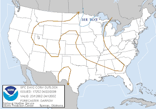 The Friday Outlook as of 12:30 PM this afternoon is to the left. There is thinking that the storms that'll form late day and overnight in the region along a cold front moving through will cause the possibility of mainly large hail. It is unclear though how much moisture will actually reach these areas tomorrow to help fuel the storm growth and any hail growth. The greatest risk of any severe weather is in that blue "SEE TEXT" area that I drew in for your viewing pleasure. This is not going to be a big severe threat, it will likely be just scattered storms. I doubt this will be raised to a Slight Risk tomorrow, and I doubt any watches will have to be issued for the area. It's just something to look out for late late tomorrow and into the overnight.
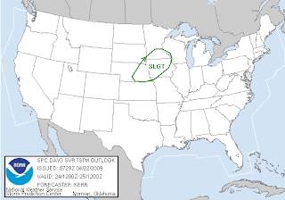 This is the severe weather threat for your Saturday as of early this morning, and they have issued a Slight Risk of Severe Storms from about the Twin Cities southward, through Iowa and into Nebraska. It is thought there will be enough energy to break the cap on the atmosphere in the afternoon in eastern Nebraska and western Iowa, allowing for the formation of individual storms. While the primary threats will be very large hail and damaging winds in these areas, wind profiles hint that there may be a possibility of a few tornadoes. The storms will then form into a line towards the evening time frame, and damaging winds will become the main threat along with large hail as the system looks to push north and east.
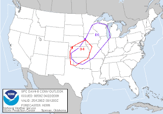 This is the Days 4-8 outlook issued early this morning, and as you can see there will be another severe weather threat on Day 5 (Sunday) from the Twin Cities south and eastward. As this threat is days out, its not as easy to say what type of severe weather could be possible, but right now we could see individual cells form to the south, possibly leaving the chance open for tornadoes down south along with damaging winds and large hail, but then form into one or more lines, creating the biggest threat for damaging winds and large hail at that time.
While I am talking about the possibility of these severe threats, there is nothing that says these chances won't happen and fizzle out, especially the Thursday chance. It's good to stay informed though! Thursday is also Tornado Day in Minnesota, we'll have more on that tomorrow.
DJ
SWAW, Day 3: Floods and Flash Floods
It's Severe Weather Awareness Week in MN and WI, which means its time to start going over what everything is again and what precautions to take when severe weather strikes. The Storm Prediction Center is now charting out a possibility of strong to severe storms on Thursday for the Arrowhead of MN stretching down to the STC area, with the main threats being damaging winds and hail, and a Slight Risk of Severe Storms Friday and Sunday around the area (we'll have more on the threat later today), so now is as good as time as any to relearn what we do in summertime, like how we have to relearn the winter warnings (and how to drive) in the winter. Remember, throughout the summer we'll cover it the best we can on Facebook and Twitter. Today's topic, brought to you by the National Weather Service, is Floods and Flash Floods -- I have included the watch, warning, and advisory criteria at the beginning, followed by the information that the NWS issued for today's topic.
Floods and Flash Floods
Floods and Flash Floods
Watches...
Flood Watch... Atmospheric and hydrologic conditions are favorable for long duration areal or river flooding.
Flash Flood Watch... Atmospheric and hydrologic conditions are favorable for short duration flash flooding and/or a dam break is possible.
Warnings...
Flood Warning... Long duration areal or river flooding is occurring or is imminent, which may result from excessive rainfall, rapid snow melt, ice jams on rivers, or other similar causes.
Flash Flood Warning... Excessive rainfall producing thunderstorms have developed, leading to short duration flash flooding. A warning may also be issued if a dam break has occurred.
Advisories...
Urban and Small Stream Advisory... Thunderstorms have produced heavy rainfall that may result in ponding of water on roadways and in low-lying areas, as well as rises in small stream levels, none of which pose an immediate threat to life and property.
On a National Level... Floods claim nearly 200 lives annually, force 300,000 persons from their homes, and result in property damage in excess of 2 billion dollars. Characteristically, 75 percent of flash flood deaths occur at night with half of the victims dying in their automobiles or other vehicles. It may be difficult to believe, but many deaths occur when persons knowingly drive around road barricades indicating the road is washed out ahead.
Last Year in Minnesota and Wisconsin... Wisconsin had one flood-related fatality last year, late on June 12th near Wales, when a man drove into a flooded area. Minnesota also had one flood-related fatality in 2008. This occurred on June 12th near Oakland when a man drove into a flooded area
In 2007... Disastrous flooding struck southeast Minnesota and southwest Wisconsin on August 18th and 19th. Eight people died that weekend... 7 in Minnesota and 1 in Wisconsin. Most deaths occurred in vehicles. A statewide record for 24-hour rainfall was set in Minnesota when 15.1 inches fell 1 mile south of Hokah.
Are You Prepared? Assume a thunderstorm produces 6 inches of rain in less than 6 hours time near your community. Storms of this magnitude or greater occur several times each year in the U.S. Would you know what action to take to protect yourself and the people who depend on you for safety? After a major flood event, one of the most common quotes from the survivors of the flood is the expression they did not believe it could happen to them or in their community.
Before the Flooding... There is nothing anyone can do to prevent the occurrence of flash flood producing rainfall. However, by striving for sound flood plain zoning, developing an emergency action plan in advance of the disaster, purchasing flood insurance at least 30 days before the flooding, and being aware of the dangers associated with extremely heavy rainfall and flooding, there is a chance of decreasing the death toll and property damage that results from flash flooding.
Tuesday, April 21, 2009
SWAW, Day 2 Part 2: Description of Summer Watches and Warnings
It's Severe Weather Awareness Week in MN and WI, which means its time to start going over what everything is again and what precautions to take when severe weather strikes. The Storm Prediction Center is now charting out a possibility of strong to severe storms on Thursday, with the main threats being damaging winds and hail (for more on those severe weather events, check out yesterdays topic), so now is as good as time as any to relearn what we do in summertime, like how we have to relearn the winter warnings (and how to drive) in the winter. Remember, throughout the summer we'll cover it the best we can on Facebook and Twitter. Today's topic, brought to you by the National Weather Service, is Severe Weather Watches and Warnings, and I wasn't satisfied on what the NWS put together for today. This information also comes from the NWS, but it describes WHAT each watch and warning means -- We'll talk both tornado and severe thunderstorm today, floods on Wednesday (topic of Flash Floods), tornado again Thursday (Tornado day), and heat on Friday (to go along with topic of Heat Waves).
Watches... (Conditions are favorable or expected but not occurring or imminent.)

Atmospheric conditions are favorable for the development of severe thunderstorms (i.e. – producing hail at least 1.00 inches in diameter and/or 50 knot [58 mph] or greater wind speeds).
Atmospheric conditions are favorable for the development of severe thunderstorms capable of producing tornadoes.
Warnings... (Conditions are occurring or imminent.)

A severe thunderstorm has developed, capable of producing hail greater than 1.00 inches in diameter and/or 50 knot (58 mph) wind speeds.
A severe thunderstorm has developed and has either produced a tornado or radar has indicated intense low level rotation in the presence of atmospheric conditions conducive to tornado development.
Advisories...
Significant Weather Alert... A thunderstorm has developed and is capable of producing hail and gusty winds that approach but do not reach those contained in a severe thunderstorm, such as pea sized hail and 40 to 50 mph winds.
Watches... (Conditions are favorable or expected but not occurring or imminent.)
Atmospheric conditions are favorable for the development of severe thunderstorms (i.e. – producing hail at least 1.00 inches in diameter and/or 50 knot [58 mph] or greater wind speeds).
Atmospheric conditions are favorable for the development of severe thunderstorms capable of producing tornadoes.
Warnings... (Conditions are occurring or imminent.)
A severe thunderstorm has developed, capable of producing hail greater than 1.00 inches in diameter and/or 50 knot (58 mph) wind speeds.
A severe thunderstorm has developed and has either produced a tornado or radar has indicated intense low level rotation in the presence of atmospheric conditions conducive to tornado development.
Advisories...
Significant Weather Alert... A thunderstorm has developed and is capable of producing hail and gusty winds that approach but do not reach those contained in a severe thunderstorm, such as pea sized hail and 40 to 50 mph winds.
SWAW, Day 2: Watches, Warnings, and How To Receive Them
It's Severe Weather Awareness Week in MN and WI, which means its time to start going over what everything is again and what precautions to take when severe weather strikes. The Storm Prediction Center is now charting out a possibility of strong to severe storms on Thursday, with the main threats being damaging winds and hail (for more on those severe weather events, check out yesterdays topic), so now is as good as time as any to relearn what we do in summertime, like how we have to relearn the winter warnings (and how to drive) in the winter. Remember, throughout the summer we'll cover it the best we can on Facebook and Twitter. Today's topic, brought to you by the National Weather Service, is Severe Weather Watches and Warnings, and How to Receive Severe Weather Information.
Severe Weather Watches and Warnings, and How to Receive Severe Weather Information
Watches... Are issued when conditions are favorable for tornadoes, severe thunderstorms or flash floods. If you are in a watch area, continue with normal activities but also make plans to seek shelter if necessary.
Warnings... Are issued when severe weather has been reported or is imminent. Seek shelter immediately if you are in or near the path of the storm. Warnings are issued by county and city names. Make sure you know the name of the county in which you live and the cities that surround you.
Advance Information... The forecast and warning process begins one or more days ahead of time, when the threat area is determined. Hazardous weather outlooks are issued early every morning, and updated as conditions warrant.
If a Watch is Issued... Local weather offices are staffed with extra personnel. State officials are notified and they pass the information to the county and local level. Counties and cities activate their spotter groups as the threat increases. TV and radio stations pass the word to the public.
If a Warning is Issued... Warnings are disseminated swiftly in a multitude of ways, including TV, radio, and over the internet. Advances in technology have allowed people to receive warnings via cell phone, pager, and numerous other methods. Spotters provide important reports on the storm, and emergency officials carry out the plans that the emergency managers have developed. Updates are issued frequently until the immediate threat has ended.
Sirens... Counties and cities own the sirens and therefore decide how and when to activate them. The National Weather Service does not sound them. There are many different policies by counties and cities. Some will activate them across the entire county for a tornado warning only. Others will activate sirens countywide for tornado warnings and all severe thunderstorm warnings. Some will activate sirens across the entire county for tornado warnings and severe thunderstorms that have winds of at least 70 or 75 mph. Others will activate sirens only for portions of counties. Also, local officials may sound the sirens anytime they believe severe weather is a threat, even if there is no warning from the National Weather Service.
Sirens normally sound about 3 minutes and then go silent. It is very rare to keep the sirens sounding for the entire warning, since that will cause the backup battery to run out, which would be critical in the event power goes out. Furthermore, the siren motor will fail much more quickly if the siren sounds continuously. Some jurisdictions may repeat siren activation every few minutes. There is no such thing as an "All Clear" for storms.
Media... Media outlets receive the warning information and disseminate it to you, often by interrupting programming. Many television stations use a crawl and other visual means.
NOAA Weather Radio... The tone alert feature of NOAA Weather Radio will activate specially built receivers, sounding an alarm to alert you to the danger. It sounds its alert anytime the National Weather Service issues a warning, even in the middle of the night. Make sure you have a NOAA Weather Radio, as you can not always depend on sirens, phone calls or seeing the warnings on television.
Monday, April 20, 2009
SWAW, Day 1: T-Storms, Hail, Wind, and Lightning
It's Severe Weather Awareness Week in MN and WI, which means its time to start going over what everything is again and what precautions to take when severe weather strikes. Some models are charting out a possibility of severe weather here as soon as this weekend (no word though from the Storm Prediction Center yet), so now is as good as time as any to relearn what we do in summertime, like how we have to relearn the winter warnings (and how to drive) in the winter. Remember, throughout the summer we'll cover it the best we can on Facebook and Twitter. Today's topic, brought to you by the National Weather Service, is Thunderstorms, Hail, Wind, and Lightning.Thunderstorms, Hail, Wind and Lightning
Thunderstorms... Affect relatively small areas when compared with most other storms. The typical thunderstorm is 15 miles in diameter and lasts for 30 minutes. Despite this size, all thunderstorms are dangerous. Severe thunderstorms produce large hail or winds of at least 58 mph. Some wind gusts can exceed 100 mph and produce tornado-like damage. Many communities will sound their outdoor sirens for very damaging straight-line winds. When a severe thunderstorm threatens, stay inside a strong structure. Mobile home occupants should go to a more permanent structure.
Hail... Is another product of thunderstorms that annually causes nearly one billion dollars in damage throughout the United States. Many of the losses are incurred by farmers. The most common diameter is pea size, but hail can be as large as golf balls and baseballs. In extreme cases, hail can reach grapefruit size. Large hail stones fall at speeds faster than 100 mph and have been known to kill people.
The largest hail stone in Minnesota last year was 3.5 inches on three separate occasions: May 25 near Maple Lake, May 25 near Monticello, and August 13 near Edgerton. Wisconsin's largest hailstone in 2008 was 4.0 inches in diameter, falling on April 25 near Tomahawk in Lincoln County.
Thunderstorm Winds... Thunderstorms can produce strong wind gusts. These straight-line winds have been known to exceed 100 mph. For this reason, you should treat severe thunderstorms just as you would tornadoes. Move to an appropriate shelter if you're in the path of the storm.
The strong outrush of wind from a thunderstorm is often called a downburst. One of the primary causes is rain-cooled air, which accelerates rapidly downward, producing a potentially damaging gust of wind.
Strong downbursts are often mistaken for tornadoes. They can produce extensive damage and are often accompanied by a roaring sound similar to that of a tornado. Downbursts can easily overturn mobile homes, tear roofs off of houses, and topple trees. People who are camping are especially vulnerable, due to trees toppling on their camp site.
The highest thunderstorm wind gust last year in Wisconsin was 90 mph, near East Troy on June 12 and on July 10 near McFarland. The highest thunderstorm wind gust in Minnesota last year was 86 mph, occurring on July 31st at Madison.
Lightning... Every thunderstorm produces lightning, which on a national basis kills more people than tornadoes in a given year.
Lightning kills around 100 Americans annually, with about 300 injuries. In Wisconsin and Minnesota, there have been many deaths and injuries over the years, most in areas such as camp grounds, although people have been injured indoors when talking on the phone.
The following are some lightning safety tips...
1. All thunderstorms produce lightning. It is surprising that so many people are not aware of this.
2. Get inside a building or enclosed vehicle. Many fatalities occur when the warning signs are ignored.
3. If caught in an open area with lightning all around, crouch down immediately! Put your hands on your knees but do not lie down on the ground.
4. Do not use a telephone or electrical appliance. A nearby lightning strike can travel through the phone or power lines right into the home.
5. Avoid seeking shelter beneath lone trees.
Myths and facts about lightning...
Myth: If it's not raining, there is no danger from lightning.
Fact: Lightning often strikes away from heavy rainfall, and may occur as far as 10 miles away from any rainfall.
Myth: Rubber soles of shoes or rubber tires on a car will protect you from being injured by lightning.
Fact: Rubber provides no protection from lightning. However, the steel frame of a hard-topped vehicle provides increased protection from lightning (if you are not touching metal in the car).
Myth: People struck by lightning carry an electrical charge and should not be touched.
Fact: Lightning-strike victims carry no electrical charge and should be attended to immediately.
Myth: Heat lightning occurs after very hot summer days and poses no threat.
Fact: What is referred to as "heat lightning" is actually lightning from a thunderstorm too far away for thunder to be heard. However, the storm may be moving in your direction.
Subscribe to:
Posts (Atom)

.JPG)