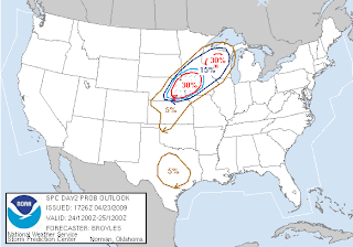
 This is the latest outlook for Friday from the Storm Prediction Center, and its a probabilistic outlook, showing where the higher chances of severe storms are. As a quick overview for those of you who don't know what everything means on this map, the numbers represent the probability of severe weather within 20 miles of any given location. Within the blue slanted "hatched area" there is at least a 10% risk of "significant severe weather" within 25 miles of any point. Typically in these blue marked territories we look for the worse weather of the day, whether it be large hail, damaging winds, or tornadoes. From looking at everything, I agree with this "hatched area". The greatest risk of severe weather will be in the Iowa and Nebraska areas, and might contain very large hail, damaging winds, and a few tornadoes. Cities in this area would include Sioux Falls and Sioux City. Parts of Wisconsin also have a higher chance of severe weather, but that will mainly be in the large hail and damaging wind categories. So according to the graphics I have looked at, the greatest threat of severe weather will be definitely south and east of the STC area. The closer you get to Iowa or Wisconsin tomorrow, though, the more the odds go up of seeing severe storms. Cities such as Fairmont, Mankato, Worthington, and Albert Lea, and even the Twin Cites will need to be on the lookout tomorrow. As you can see, this area is also really close to the STC area. More than likely the cold front will have pushed southward enough to keep us out of the severe area, but even so people in the STC area should keep a look out for the possibility of severe weather since the boundaries are still so close to the area. Watches and warnings are likely tomorrow, especially in NE/IA/WI... I'll be updating if any of these decides to strike close to home. Also, expect an update by 2 PM tomorrow on the latest on the severe weather threat for the area.
Thursday, April 23, 2009
A Look at the Severe Chance Friday
 This is the latest outlook for Friday from the Storm Prediction Center, and its a probabilistic outlook, showing where the higher chances of severe storms are. As a quick overview for those of you who don't know what everything means on this map, the numbers represent the probability of severe weather within 20 miles of any given location. Within the blue slanted "hatched area" there is at least a 10% risk of "significant severe weather" within 25 miles of any point. Typically in these blue marked territories we look for the worse weather of the day, whether it be large hail, damaging winds, or tornadoes. From looking at everything, I agree with this "hatched area". The greatest risk of severe weather will be in the Iowa and Nebraska areas, and might contain very large hail, damaging winds, and a few tornadoes. Cities in this area would include Sioux Falls and Sioux City. Parts of Wisconsin also have a higher chance of severe weather, but that will mainly be in the large hail and damaging wind categories. So according to the graphics I have looked at, the greatest threat of severe weather will be definitely south and east of the STC area. The closer you get to Iowa or Wisconsin tomorrow, though, the more the odds go up of seeing severe storms. Cities such as Fairmont, Mankato, Worthington, and Albert Lea, and even the Twin Cites will need to be on the lookout tomorrow. As you can see, this area is also really close to the STC area. More than likely the cold front will have pushed southward enough to keep us out of the severe area, but even so people in the STC area should keep a look out for the possibility of severe weather since the boundaries are still so close to the area. Watches and warnings are likely tomorrow, especially in NE/IA/WI... I'll be updating if any of these decides to strike close to home. Also, expect an update by 2 PM tomorrow on the latest on the severe weather threat for the area.
Subscribe to:
Post Comments (Atom)

No comments:
Post a Comment