Hi! |
Wednesday, February 29, 2012
no more strict deadlines
Tuesday, July 27, 2010
NOTICE: Blog has relocated
Please note that this blog has relocated to http://weathrlver.wordpress.com -- More weather information there!
Sunday, May 23, 2010
Severe Thunderstorm Watch until 10 PM includes Stearns, Benton and Sherburne

A Severe Thunderstorm Watch has just been issued for the St. Cloud area, including Stearns, Benton and Sherburne Counties. The watch goes until 10 PM, and also includes parts of the northern Twin Cities and the Duluth area. Storms are starting to initiate within the watch area, and could go severe shortly. Large hail up to 1.5 inches in diameter and damaging winds up to 70 MPH appear to be the main threats along with typical cloud-to-ground lightning associated with thunderstorms. I'm not too sure on the threat for the St. Cloud area (front might already be too close), but it does increase as you head east of the area.
What follows below is the watch area image and the statement from the Storm Prediction Center. We will have updated watch areas, warnings and statements as they are issued, mainly ones which impact the STC area.

URGENT - IMMEDIATE BROADCAST REQUESTED
SEVERE THUNDERSTORM WATCH NUMBER 206
NWS STORM PREDICTION CENTER NORMAN OK
305 PM CDT SUN MAY 23 2010
THE NWS STORM PREDICTION CENTER HAS ISSUED A
SEVERE THUNDERSTORM WATCH FOR PORTIONS OF
NORTHEAST AND PARTS OF EAST-CENTRAL MINNESOTA
NORTHWEST WISCONSIN
LAKE SUPERIOR
EFFECTIVE THIS SUNDAY AFTERNOON AND EVENING FROM 305 PM UNTIL
1000 PM CDT.
HAIL TO 1.5 INCHES IN DIAMETER...THUNDERSTORM WIND GUSTS TO 70
MPH...AND DANGEROUS LIGHTNING ARE POSSIBLE IN THESE AREAS.
THE SEVERE THUNDERSTORM WATCH AREA IS APPROXIMATELY ALONG AND 60
STATUTE MILES EAST AND WEST OF A LINE FROM 30 MILES EAST
NORTHEAST OF ELY MINNESOTA TO 20 MILES EAST SOUTHEAST OF SAINT
CLOUD MINNESOTA. FOR A COMPLETE DEPICTION OF THE WATCH SEE THE
ASSOCIATED WATCH OUTLINE UPDATE (WOUS64 KWNS WOU6).
REMEMBER...A SEVERE THUNDERSTORM WATCH MEANS CONDITIONS ARE
FAVORABLE FOR SEVERE THUNDERSTORMS IN AND CLOSE TO THE WATCH
AREA. PERSONS IN THESE AREAS SHOULD BE ON THE LOOKOUT FOR
THREATENING WEATHER CONDITIONS AND LISTEN FOR LATER STATEMENTS
AND POSSIBLE WARNINGS. SEVERE THUNDERSTORMS CAN AND OCCASIONALLY
DO PRODUCE TORNADOES.
DISCUSSION...TSTMS ARE EXPECTED TO GRADUALLY INTENSIFY THIS
AFTERNOON ALONG STALLING SURFACE FRONT WHERE INFLOW AIR MASS HAS
BECOME MODERATELY TO STRONGLY UNSTABLE WITH MLCAPE OF 1500-3000
J/KG. REGION WILL REMAIN ALONG THE ERN FRINGE OF STRONGER MID AND
HIGH-LEVEL WIND FIELD WITH 30-40 KT OF DEEP-LAYER SHEAR RESIDING
ALONG FRONTAL ZONE. AS SUCH...AMBIENT ENVIRONMENT WILL BE
SUPPORTIVE OF ORGANIZED STORMS...INCLUDING SUPERCELLS WITH THE
PRIMARY HAZARDS BEING DAMAGING WIND GUSTS AND LARGE HAIL.
AVIATION...A FEW SEVERE THUNDERSTORMS WITH HAIL SURFACE AND ALOFT
TO 1.5 INCHES. EXTREME TURBULENCE AND SURFACE WIND GUSTS TO 60
KNOTS. A FEW CUMULONIMBI WITH MAXIMUM TOPS TO 500. MEAN STORM
MOTION VECTOR 25030.
...MEAD
Saturday, May 22, 2010
Severe T-Storm Watch LIKELY North of STC Shortly
UPDATE: Watch was issued around 9 PM, includes areas north and west of Alexandria.
Saturday, May 8, 2010
Snow in May? You betcha!
Ah, Spring in Minnesota. Sure, we've been spoiled so far, especially with a snowless March and April. But snow all the way into May is not as rare as you may think it is.
Overall, the St. Cloud area averages 0.1" of snow during the month of May historically. Here are some other snow facts:
Otherwise, mainly cloudy Saturday with a high around 50, and a mix of clouds and sun Sunday with a high in the middle 50s. Looking into next week: It will stay "coolish" with highs mainly around 60 (except Tuesday with a high in the lower 50s) and a chance of showers Monday into Tuesday, and again late in the week.
Now, embrace the snow. Don't go running away from it. It won't last long. And it is not out of the norm.
Overall, the St. Cloud area averages 0.1" of snow during the month of May historically. Here are some other snow facts:
- The biggest May snow? 3.2 inches on May 19, 1971 -- also the date of the latest inch of snow during the month of May in St. Cloud.
- The latest measurable snowfall? May 23, 1925. BUT snowflakes have been seen up to May 27.
- St. Cloud's last measurable snowfall in May? 0.1 inch on May 1, 2005. If we get a measurable snowfall tonight, it will be the first since then
Otherwise, mainly cloudy Saturday with a high around 50, and a mix of clouds and sun Sunday with a high in the middle 50s. Looking into next week: It will stay "coolish" with highs mainly around 60 (except Tuesday with a high in the lower 50s) and a chance of showers Monday into Tuesday, and again late in the week.
Now, embrace the snow. Don't go running away from it. It won't last long. And it is not out of the norm.
Tuesday, May 4, 2010
Weather Watch Likely Soon For Eastern MN
A severe weather watch is likely soon over portions of MN, WI, and IA, including the Twin Cities and Rochester areas. Storms are likely to develop soon, and will at least approach severe limits. The main threats appear to be large hail and damaging winds, though an isolated tornado or two cannot be ruled out, mainly over western WI. Here is the following Mesoscale Discussion from the Storm Prediction Center -- We will follow up with any watches that are issued for the area.

MESOSCALE DISCUSSION 0479
NWS STORM PREDICTION CENTER NORMAN OK
0249 PM CDT TUE MAY 04 2010
AREAS AFFECTED...SERN MN/NRN IA/WRN WI
CONCERNING...SEVERE POTENTIAL...WATCH POSSIBLE
VALID 041949Z - 042045Z
SEVERE POTENTIAL CONTINUES TO INCREASE ACROSS THE DISCUSSION
AREA...WITH WW POSSIBLE IN THE NEXT HOUR OR SO.
STRONG HEATING CONTINUES ACROSS IA/SERN MN AND INTO WRN WI
ATTM...WITH VISIBLE IMAGERY REVEALING A GENERALLY CLEAR SKY E OF
DEVELOPING LINE OF CU FROM SERN MN WSWWD ACROSS N CENTRAL AND WRN IA
INTO ERN NEB. OBJECTIVE ANALYSES REVEAL A WEAKENING CAP ALONG THE
CU FIELD -- COINCIDENT WITH THE SURFACE COLD FRONT...BUT
DESTABILIZATION REMAINS SLOW/WEAK DUE TO ONLY MODEST BOUNDARY-LAYER
MOISTURE.
CONTINUED HEATING/DESTABILIZATION THIS AFTERNOON WILL ALLOW ONGOING
CONVECTIVE DEVELOPMENT TO DEEPEN/INCREASE...EVENTUALLY RESULTING IN
THUNDERSTORM INITIATION ALONG THE FRONT. WHILE HINDERED SOMEWHAT IN
INTENSITY BY THE THERMODYNAMIC LIMITATIONS...FAVORABLE SHEAR SHOULD
AT LEAST SOMEWHAT OFFSET THIS...POSSIBLY ALLOWING SCATTERED STORMS
TO INTENSIFY TO SEVERE LEVELS. WHILE A LOW-END TORNADO POTENTIAL IS
APPARENT -- MAINLY OVER A SMALL PORTION OF WRN WI NEAR THE WARM
FRONT...MAIN SEVERE THREATS WOULD REMAIN LOCALLY-DAMAGING WINDS AND
HAIL.
Wednesday, April 28, 2010
Slight Risk of Severe Storms Thursday

Storm Prediction Center's Slight Risk area for Thursday
We are carefully watching for the possibility of some strong to severe storms over southern Minnesota during the late afternoon and evening Thursday. Currently the Storm Prediction Center has a Slight Risk of Severe Storms over much of southern Minnesota for Thursday as a cold front and low pressure area approaches the area.
Some concerns over the formation of these storms though. It looks as though over a good portion of the Slight area, stretching down to Oklahoma, will be capped, which would limit formation of storms until the cap is broken (think of a shaken up bottle of pop. The energy can't be released until you unscrew (remove) the cap).
Also, at least up in our neck of the woods, we have a dry atmosphere, which will only help set off any storms that we do get.
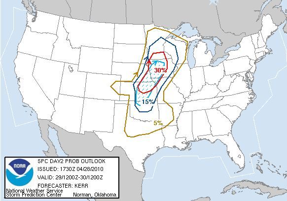
Percent probability of severe weather within 25 miles of a point -- Hatched (blue dashed area) is probability of significant severe weather within 25 miles of a point
The main threat that should occur with these storms in our area is large hail and some damaging winds. I won't rule out an isolated tornado or two, mainly in southern Minnesota (south of the cities), but the main tornado action (along with the main severe weather event) should be from Iowa down toward Kansas in the afternoon and evening.
I do not think that this will be a big outbreak in our area - more an isolated event. We could see a bigger outbreak, including tornadoes, as the system pushes eastward into Wisconsin, Iowa, Illinois, and south through Louisiana and Mississippi on Friday.
Subscribe to:
Comments (Atom)

.JPG)